

Rampur, Himachal Pradesh
Encyclopedia
Rampur Bushahr is a city and a municipal council
in Shimla district
in the India
n state
of Himachal Pradesh
. It is 130 km from Shimla well connected with National Highway which passes through Narkanda (attitude 2708m).
 The principality of Bashahr
(also known as Bashahar, Bushahar, Bushahr) was once among the largest of the twenty-eight Shimla Hill States under the administration of the British Raj
keen to invest on regional and transcontinental trade and exploit Himalayan resources. It bordered on the north with Spiti, on the east with Tibet, on the south with Garhwal
, and on the west with Jubbal, Kotkhai, Kumharsain, Kotgarh, and Kulu. Caught in the machinations of the British imperial enterprise, it was subjected to political-cum-economic vicissitudes, acceding to the Indian Union in 1947. On the 8th March 1948, along with twenty other princely hill States of Punjab and Shimla, Bashahr signed an agreement which resulted in its inclusion in the Indian State of Himachal Pradesh.
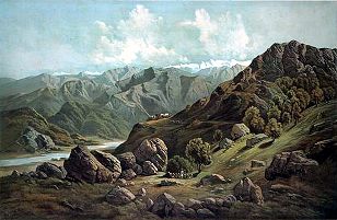
Rampur, a small township situated at 1,005 meters on the left bank of the Sutlej, served as Bashahr’s winter capital. Being well connected with major trading routes that joined Indian markets with Central Asia and Tibet, it buzzed with mercantile activity, especially in November during the Lavi fair, the largest trading event in the north Himalayas attracting traders from Kashmir, Ladakh, Yarkand, and the Indian mainland. Concerning the origins of the Rampuri fair, the Census of India (1961) reports:
"About three hundred years ago during the regime of Raja Kehar Singh of Bushahr, a trade treaty was signed between the Bushahr State and Tibet…Horses from Tibet and swords from Bushahr were exchanged in token of this friendship. It was written in the treaty that their friendly relations would continue till this time…Since then, it is presumed that trade relations increased and eventually [the] Lavi fair was held.”
Rampur was also located along pilgrimage routes to sacred sites in western Tibet shared by Hindus, Bön and Buddhists alike, i.e., Mount Kailash
and Lake Mansarovar. Missionary and pilgrimage activities, intensified by trading possibilities, created the conditions for Tibetan Buddhism to take a firm stronghold in these borderland regions. Twenty-two kilometres from the village of Namgya in upper Kinnaur, laid the Shipki pass which linked caravan routes to and from western Tibet
. This treacherous transcontinental passage must have been in use from ancient times, for among the ruined castles reported by Francke at Shipki village, there were no living memories of the origins of mKar gog, the oldest of them built above the village in cyclopean style.Rampur also have Hydo electric projects like NJPC and Rmpur Project bye SJVNL A second castle, known as Seng ge mkhar, is said to have received its crooked ground plan “through a race round its base executed in opposite directions by a poisonous snake and a scorpion,” and was built, in all probability, during the Ladakhi occupation of mNga’ ris by orders of King Seng ge rnam rgyal (1570–1642) and called after him.It is 30 km from SAINJ.
s (4429 feet). It is at the bank of river Sutlej.Rampur is very beautiful place situated at the bank of the river satluj. The city has very popular places like Jhakri,Sarhan and Green valley Gaura,shrai koti like some beautiful places. The city also have Asia's Largest Hydro Project Nathpa Jhakri Power Corp. at Jhakri and Also have world's deepest Surge shaft at shah 22 K.M. away from Rampur.
Municipal council
A municipal council is the local government of a municipality. Specifically the term can refer to the institutions of various countries that can be translated by this term...
in Shimla district
Shimla district
Shimla district of Himachal Pradesh, lies between the longitude 77.00" and 78.19" east and latitude 30.45" and 31.44" north, has its headquarters at Shimla city. It is surrounded by Mandi and Kullu in the north, Kinnaur in the east, Uttarakhand in the south, Sirmaur in the west...
in the India
India
India , officially the Republic of India , is a country in South Asia. It is the seventh-largest country by geographical area, the second-most populous country with over 1.2 billion people, and the most populous democracy in the world...
n state
States and territories of India
India is a federal union of states comprising twenty-eight states and seven union territories. The states and territories are further subdivided into districts and so on.-List of states and territories:...
of Himachal Pradesh
Himachal Pradesh
Himachal Pradesh is a state in Northern India. It is spread over , and is bordered by the Indian states of Jammu and Kashmir on the north, Punjab on the west and south-west, Haryana and Uttar Pradesh on the south, Uttarakhand on the south-east and by the Tibet Autonomous Region on the east...
. It is 130 km from Shimla well connected with National Highway which passes through Narkanda (attitude 2708m).
History
Bashahr
Bashahr was a princely state in pre-independence India, located in the hilly western Himalaya promontory in the northern part of colonial Punjab that is now the Indian republic's state of Himachal Pradesh and traversed by the Sutlej river...
(also known as Bashahar, Bushahar, Bushahr) was once among the largest of the twenty-eight Shimla Hill States under the administration of the British Raj
British Raj
British Raj was the British rule in the Indian subcontinent between 1858 and 1947; The term can also refer to the period of dominion...
keen to invest on regional and transcontinental trade and exploit Himalayan resources. It bordered on the north with Spiti, on the east with Tibet, on the south with Garhwal
Garhwal Division
Garhwal is the north-western region and administrative division of the northern Indian state of Uttarakhand which is home to the Garhwali people. Lying in the Himalayas, It is bounded on the north by Tibet, on the east by Kumaon region, on the south by Uttar Pradesh state, and on the north-west by...
, and on the west with Jubbal, Kotkhai, Kumharsain, Kotgarh, and Kulu. Caught in the machinations of the British imperial enterprise, it was subjected to political-cum-economic vicissitudes, acceding to the Indian Union in 1947. On the 8th March 1948, along with twenty other princely hill States of Punjab and Shimla, Bashahr signed an agreement which resulted in its inclusion in the Indian State of Himachal Pradesh.
Rampur, a small township situated at 1,005 meters on the left bank of the Sutlej, served as Bashahr’s winter capital. Being well connected with major trading routes that joined Indian markets with Central Asia and Tibet, it buzzed with mercantile activity, especially in November during the Lavi fair, the largest trading event in the north Himalayas attracting traders from Kashmir, Ladakh, Yarkand, and the Indian mainland. Concerning the origins of the Rampuri fair, the Census of India (1961) reports:
"About three hundred years ago during the regime of Raja Kehar Singh of Bushahr, a trade treaty was signed between the Bushahr State and Tibet…Horses from Tibet and swords from Bushahr were exchanged in token of this friendship. It was written in the treaty that their friendly relations would continue till this time…Since then, it is presumed that trade relations increased and eventually [the] Lavi fair was held.”
Rampur was also located along pilgrimage routes to sacred sites in western Tibet shared by Hindus, Bön and Buddhists alike, i.e., Mount Kailash
Mount Kailash
Mount Kailash is a peak in the Gangdisê Mountains, which are part of the Himalayas in Tibet...
and Lake Mansarovar. Missionary and pilgrimage activities, intensified by trading possibilities, created the conditions for Tibetan Buddhism to take a firm stronghold in these borderland regions. Twenty-two kilometres from the village of Namgya in upper Kinnaur, laid the Shipki pass which linked caravan routes to and from western Tibet
Tibet
Tibet is a plateau region in Asia, north-east of the Himalayas. It is the traditional homeland of the Tibetan people as well as some other ethnic groups such as Monpas, Qiang, and Lhobas, and is now also inhabited by considerable numbers of Han and Hui people...
. This treacherous transcontinental passage must have been in use from ancient times, for among the ruined castles reported by Francke at Shipki village, there were no living memories of the origins of mKar gog, the oldest of them built above the village in cyclopean style.Rampur also have Hydo electric projects like NJPC and Rmpur Project bye SJVNL A second castle, known as Seng ge mkhar, is said to have received its crooked ground plan “through a race round its base executed in opposite directions by a poisonous snake and a scorpion,” and was built, in all probability, during the Ladakhi occupation of mNga’ ris by orders of King Seng ge rnam rgyal (1570–1642) and called after him.It is 30 km from SAINJ.
Geography
Rampur is located at 31.45°N 77.63°E. It has an average elevation of 1350 metreMetre
The metre , symbol m, is the base unit of length in the International System of Units . Originally intended to be one ten-millionth of the distance from the Earth's equator to the North Pole , its definition has been periodically refined to reflect growing knowledge of metrology...
s (4429 feet). It is at the bank of river Sutlej.Rampur is very beautiful place situated at the bank of the river satluj. The city has very popular places like Jhakri,Sarhan and Green valley Gaura,shrai koti like some beautiful places. The city also have Asia's Largest Hydro Project Nathpa Jhakri Power Corp. at Jhakri and Also have world's deepest Surge shaft at shah 22 K.M. away from Rampur.
External links
- Photographs of Rampur-Bashahr http://sas-space.sas.ac.uk/cgi/search/advanced?screen=Public%3A%3AEPrintSearch&_action_search=Search&_fulltext__merge=ALL&_fulltext_=&title_merge=ALL&title=rampur&creators_name_merge=ALL&creators_name=&date=&keywords_merge=ALL&keywords=&subjects_merge=ALL&divisions=war&divisions_merge=ALL&collections_merge=ALL&satisfyall=ALL&order=-date%2Fcreators_name%2Ftitle in SAS-Space