
Radford, Coventry
Encyclopedia
Radford is a suburb and electoral ward of Coventry
, located approximately 2 miles north of Coventry city centre. It is covered by the Coventry North West
constituency.
, Foleshill
, St Michael's, Sherbourne, and Bablake wards. It is covered by the North East Neighbourhood Management area. It covers an area of 303.9 hectare
s.
Radford consists of four neighbourhoods; Radford Diamond, East Radford, West Radford, and Canal Basin. Radford Diamond is located approximately one mile to the northwest of Coventry city centre and is bounded by Barkers Butts Lane, Lawrence Saunders Road and the Radford Road with the Coventry-Nuneaton railway forming the southern boundary. East Radford is a small neighbourhood consisting of six streets of densely populated housing: Newfield Road, Dorset Road, Somerset Road, Widdrington Road, Kingfield Road and Aldbourne Road. The Coventry-Nuneaton railway bounds the area on one side whilst the Coventry Canal
bounds the other. West Radford is a large neighbourhood with a population of approximately 3,800, located approximately two miles north of the city centre. The Jubilee Crescent area, the area around St. Augustine's School and the Beake Avenue/Radford Road area are the three distinct parts to the neighbourhood. The Canal Basin neighbourhood comprises Leicester Row, St Nicholas Street, St Columbas' Close and the Drapers Field development.
and also the railway, and was served by Radford railway station, located on Sandy Lane. This was also the site of the Sandy Lane power station, which has now been turned into a mixed use residential and business development - Electric Wharf.
Possibly Radford's greatest historical claim to fame comes from its centrality in the birth of the British motor car industry. The Great Horseless Carriage Company was established in 1896 in converted cotton mill works, and renamed Motor Mills, between St. Nicholas Street, Sandy Lane, and the Coventry Canal. It included a red-brick office block with stone banding on Sandy Lane built 1907-8, and an electricity power house which was added in 1907. Soon after, the company changed its name to Daimler
and shortly before World War I
, they moved to a new factory at the Lydgate Road/Sandy Lane Junction. The factory was greatly extended during and after World War I to incorporate entrances on both Sandy Lane and Middlemarch Road. After a merger in 1960, the factory also became home to Jaguar
, who remained there till production ceased in the mid-1990s.
Between the world wars, and for a short time only, Radford was home to an aerodrome situated close to the Daimler factory, the site of which is now taken by Joseph Cash Primary School and The Coventrians RFC.
During the "Coventry Blitz
" in World War II
, Radford became a major target for the Luftwaffe
due to the presence of the Daimler and the nearby Alvis
factories, who were both producing, munitions and essential vehicles for the British war effort. With the exception of the office block on Sandy Lane and the electricity power house, Motor Mills was destroyed in the blitz. On November 19, 1940, a landmine suspended by parachute was dropped by the Luftwaffe and exploded above ground, destroying St Nicholas Church, leaving only one course of stones standing. Some of the people seeking shelter in the church crypt were killed or injured.
, Radford ward had a population of 16,901, with a population density
of 55.6 persons per hectare. Of the 16,901 people living in Radford, 1,373 were students and 5,308 owned a car. 11,960 people were of a working age whilst 565 people were unemployed. In 2005, the average household income in Radford was £25,015. In 2004, the average house price was £
101,583.94.
and the village of Fillongley
. Radford Road is home to several small shops, and a bingo hall. Radford's other main shopping area is Jubilee Crescent in the northern part of Radford, which also hosts a library, community centre and doctors' surgery as well as many local businesses and branches of national retail chains. Jubilee Crescent was named to commemorate the then forthcoming silver jubilee
of King George V
in 1935.
Most of the northern area of Radford is residential, following development during the 20th century. Properties range from blocks of flats to semi-detached and terraced housing, and includes both privately owner-occupied properties and council housing. The Right to buy scheme
decreased the prevalence of local authority housing in the area from the 1980s onwards, and remaining properties were transferred (along with the rest of Coventry City Council's housing stock) to Whitefriars Housing Group
in 2000.
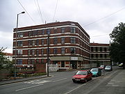
Although Radford has endured the closure of many of its key employers in recent years, regeneration efforts are easily visible. The site of Radford Rail Station has been developed into an apartment complex; Sandy Lane Power Station, which became offices for the East Midlands Electricity Board
, has been redeveloped into Electric Wharf, a mixed-use site incorporating residential buildings and public art; and the former Daimler works are now a residential area known as Daimler Green
.
is the coeducational comprehensive secondary school in the area. It was an all girls grammar school until the 1970s (approx date).
who went on to be European champion in the eighties and a regular fixture on ITV Fight Night.
Another former resident was Phillip Larkin, widely regarded as one of the greatest English poets of the latter half of the twentieth century.
Coventry
Coventry is a city and metropolitan borough in the county of West Midlands in England. Coventry is the 9th largest city in England and the 11th largest in the United Kingdom. It is also the second largest city in the English Midlands, after Birmingham, with a population of 300,848, although...
, located approximately 2 miles north of Coventry city centre. It is covered by the Coventry North West
Coventry North West (UK Parliament constituency)
Coventry North West is a borough constituency in the city of Coventry which is represented in the House of Commons of the Parliament of the United Kingdom...
constituency.
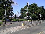
Geography
Radford ward is bounded by HolbrooksHolbrooks
Holbrooks, also written Holbrook's, is a residential area of Coventry, West Midlands, England.Most of the length of the four brooks which pass through the area are covered or culverted, one culvert is adjacent to the recently built housing on Watery Lane. Another brook passes through and under the...
, Foleshill
Foleshill
Foleshill is a suburb in the north of Coventry in the West Midlands of England.Longford. Courthouse Green and Rowley Green are to its north and Keresley is to its west.- History :...
, St Michael's, Sherbourne, and Bablake wards. It is covered by the North East Neighbourhood Management area. It covers an area of 303.9 hectare
Hectare
The hectare is a metric unit of area defined as 10,000 square metres , and primarily used in the measurement of land. In 1795, when the metric system was introduced, the are was defined as being 100 square metres and the hectare was thus 100 ares or 1/100 km2...
s.
Radford consists of four neighbourhoods; Radford Diamond, East Radford, West Radford, and Canal Basin. Radford Diamond is located approximately one mile to the northwest of Coventry city centre and is bounded by Barkers Butts Lane, Lawrence Saunders Road and the Radford Road with the Coventry-Nuneaton railway forming the southern boundary. East Radford is a small neighbourhood consisting of six streets of densely populated housing: Newfield Road, Dorset Road, Somerset Road, Widdrington Road, Kingfield Road and Aldbourne Road. The Coventry-Nuneaton railway bounds the area on one side whilst the Coventry Canal
Coventry Canal
The Coventry Canal is a navigable narrow canal in the Midlands of England.It starts in Coventry and ends 38 miles north at Fradley Junction, just north of Lichfield, where it joins the Trent and Mersey Canal...
bounds the other. West Radford is a large neighbourhood with a population of approximately 3,800, located approximately two miles north of the city centre. The Jubilee Crescent area, the area around St. Augustine's School and the Beake Avenue/Radford Road area are the three distinct parts to the neighbourhood. The Canal Basin neighbourhood comprises Leicester Row, St Nicholas Street, St Columbas' Close and the Drapers Field development.
History
Originally Radford was a Roman settlement and this is borne out by some of the local street names inc' Villa road and of course its name Radford an abbreviation for roman ford (low river crossing) the ford originates from a natural spring from the rear of the now Gala bingo building and is adjacent to Poole road this can be found on old maps of the area when that land once belonging to the estate where the old Radford public house stood - there are still public rights of access if you wish to locate it exactly, interestingly the water now passes all the way into the City centre and provides Nauls mill park and pool with it water and then feeds into Swanswell park and pool. At the end of the 19th century, Radford was turning from a largely undeveloped rural area into one of Coventry's major manufacturing areas. The southern area of Radford benefited from the presence of the Coventry CanalCoventry Canal
The Coventry Canal is a navigable narrow canal in the Midlands of England.It starts in Coventry and ends 38 miles north at Fradley Junction, just north of Lichfield, where it joins the Trent and Mersey Canal...
and also the railway, and was served by Radford railway station, located on Sandy Lane. This was also the site of the Sandy Lane power station, which has now been turned into a mixed use residential and business development - Electric Wharf.
Possibly Radford's greatest historical claim to fame comes from its centrality in the birth of the British motor car industry. The Great Horseless Carriage Company was established in 1896 in converted cotton mill works, and renamed Motor Mills, between St. Nicholas Street, Sandy Lane, and the Coventry Canal. It included a red-brick office block with stone banding on Sandy Lane built 1907-8, and an electricity power house which was added in 1907. Soon after, the company changed its name to Daimler
Daimler Motor Company
The Daimler Motor Company Limited was an independent British motor vehicle manufacturer founded in London by H J Lawson in 1896, which set up its manufacturing base in Coventry. The right to the use of the name Daimler had been purchased simultaneously from Gottlieb Daimler and Daimler Motoren...
and shortly before World War I
World War I
World War I , which was predominantly called the World War or the Great War from its occurrence until 1939, and the First World War or World War I thereafter, was a major war centred in Europe that began on 28 July 1914 and lasted until 11 November 1918...
, they moved to a new factory at the Lydgate Road/Sandy Lane Junction. The factory was greatly extended during and after World War I to incorporate entrances on both Sandy Lane and Middlemarch Road. After a merger in 1960, the factory also became home to Jaguar
Jaguar (car)
Jaguar Cars Ltd, known simply as Jaguar , is a British luxury car manufacturer, headquartered in Whitley, Coventry, England. It is part of the Jaguar Land Rover business, a subsidiary of the Indian company Tata Motors....
, who remained there till production ceased in the mid-1990s.
Between the world wars, and for a short time only, Radford was home to an aerodrome situated close to the Daimler factory, the site of which is now taken by Joseph Cash Primary School and The Coventrians RFC.
During the "Coventry Blitz
Coventry Blitz
The Coventry blitz was a series of bombing raids that took place in the English city of Coventry. The city was bombed many times during the Second World War by the German Air Force...
" in World War II
World War II
World War II, or the Second World War , was a global conflict lasting from 1939 to 1945, involving most of the world's nations—including all of the great powers—eventually forming two opposing military alliances: the Allies and the Axis...
, Radford became a major target for the Luftwaffe
Luftwaffe
Luftwaffe is a generic German term for an air force. It is also the official name for two of the four historic German air forces, the Wehrmacht air arm founded in 1935 and disbanded in 1946; and the current Bundeswehr air arm founded in 1956....
due to the presence of the Daimler and the nearby Alvis
Alvis Cars
Alvis Car and Engineering Company Ltd was a British manufacturing company that existed in Coventry, England from 19191967. In addition to automobiles designed for the civilian market, the company also produced racing cars, aircraft engines, armoured cars and other armoured fighting vehicles, the...
factories, who were both producing, munitions and essential vehicles for the British war effort. With the exception of the office block on Sandy Lane and the electricity power house, Motor Mills was destroyed in the blitz. On November 19, 1940, a landmine suspended by parachute was dropped by the Luftwaffe and exploded above ground, destroying St Nicholas Church, leaving only one course of stones standing. Some of the people seeking shelter in the church crypt were killed or injured.
Demographics
At the time of the 2001 UK CensusUnited Kingdom Census 2001
A nationwide census, known as Census 2001, was conducted in the United Kingdom on Sunday, 29 April 2001. This was the 20th UK Census and recorded a resident population of 58,789,194....
, Radford ward had a population of 16,901, with a population density
Population density
Population density is a measurement of population per unit area or unit volume. It is frequently applied to living organisms, and particularly to humans...
of 55.6 persons per hectare. Of the 16,901 people living in Radford, 1,373 were students and 5,308 owned a car. 11,960 people were of a working age whilst 565 people were unemployed. In 2005, the average household income in Radford was £25,015. In 2004, the average house price was £
Pound sterling
The pound sterling , commonly called the pound, is the official currency of the United Kingdom, its Crown Dependencies and the British Overseas Territories of South Georgia and the South Sandwich Islands, British Antarctic Territory and Tristan da Cunha. It is subdivided into 100 pence...
101,583.94.
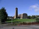
Places of interest
Radford is bordered on its western side by Radford Road, a main thoroughfare into Coventry city centre which extends out of Coventry to the areas of KeresleyKeresley
Keresley is a village and civil parish in the City of Coventry, West Midlands, England, about north of Coventry city centre. According to the 2001 census, the parish had a population of 791...
and the village of Fillongley
Fillongley
Fillongley is a village in the North Warwickshire district of the county of Warwickshire in England.The village is centred around the crossroads of the B4102 and the B4098 and Tamworth....
. Radford Road is home to several small shops, and a bingo hall. Radford's other main shopping area is Jubilee Crescent in the northern part of Radford, which also hosts a library, community centre and doctors' surgery as well as many local businesses and branches of national retail chains. Jubilee Crescent was named to commemorate the then forthcoming silver jubilee
Silver Jubilee
A Silver Jubilee is a celebration held to mark a 25th anniversary. The anniversary celebrations can be of a wedding anniversary, ruling anniversary or anything that has completed a 25 year mark...
of King George V
George V of the United Kingdom
George V was King of the United Kingdom and the British Dominions, and Emperor of India, from 6 May 1910 through the First World War until his death in 1936....
in 1935.
Most of the northern area of Radford is residential, following development during the 20th century. Properties range from blocks of flats to semi-detached and terraced housing, and includes both privately owner-occupied properties and council housing. The Right to buy scheme
Right to buy scheme
The Right to buy scheme is a policy in the United Kingdom which gives tenants of council housing the right to buy the home they are living in. Currently, there is also a right to acquire for the tenants of housing associations...
decreased the prevalence of local authority housing in the area from the 1980s onwards, and remaining properties were transferred (along with the rest of Coventry City Council's housing stock) to Whitefriars Housing Group
Whitefriars Housing Group
Whitefriars Housing Group Ltd is a housing association managing about 18,000 homes in Coventry, England. Constituted as a charitable industrial and provident society, it is Coventry's largest social landlord....
in 2000.
Although Radford has endured the closure of many of its key employers in recent years, regeneration efforts are easily visible. The site of Radford Rail Station has been developed into an apartment complex; Sandy Lane Power Station, which became offices for the East Midlands Electricity Board
East Midlands Electricity
The East Midlands Electricity Board was formed in 1947, one of the 12 area electricity boards specified under the Electricity Act 1947.-Supply area:...
, has been redeveloped into Electric Wharf, a mixed-use site incorporating residential buildings and public art; and the former Daimler works are now a residential area known as Daimler Green
Daimler Green
Daimler Green is an urban village approximately two miles north of Coventry city centre, in the West Midlands, England.It was built on the site of the Daimler factory in Radford. The railway provided a railway station for the car factory workers, Daimler Halt station was closed in 1965. The factory...
.
Education
Barr's Hill SchoolBarr's Hill School
Barr's Hill School and Community College is a comprehensive secondary school in Radford, Coventry, England.-Admissions:Barr's Hill is situated on a spacious green field site just north of Coventry city centre on the B4098 , south of the Coventry-Nuneaton Line. The site of the former Jaguar factory...
is the coeducational comprehensive secondary school in the area. It was an all girls grammar school until the 1970s (approx date).
Famous residents
A former resident of Radford was England boxing captain Errol ChristieErrol Christie
Errol Christie is a former professional British boxer and currently a boxing trainer. He was the captain of the English boxing team from 1980 to 1983 and European champion in 1983....
who went on to be European champion in the eighties and a regular fixture on ITV Fight Night.
Another former resident was Phillip Larkin, widely regarded as one of the greatest English poets of the latter half of the twentieth century.