
Radcliffe Line
Encyclopedia
The Radcliffe Line was announced on 17 August 1947 as a boundary demarcation line
between India
and Pakistan
upon the Partition of India
. The Radcliffe Line was named after its architect, Sir Cyril Radcliffe
, who as chair of the Border Commissions was tasked with equitably dividing 175000 square miles (453,247.9 km²) of territory with 88 million people.
of the Parliament of the United Kingdom
stipulated that British rule
in India would come to an end just one month later, on August 15, 1947. The Act also stipulated the partition of the Provinces of British India into two new sovereign dominion
s: the Union of India and the Dominion of Pakistan
.
Before partition, some 40% of the area of India was covered by princely state
s. These states were in subsidiary alliance
s with the British, who were responsible for their external affairs, but they were not British possessions and did not form part of British India. Thus, the British could not grant them independence, nor partition them. The Indian Independence Act abandoned the suzerainty
of the British Crown over the princely states and dissolved the Indian Empire, so that the rulers of the states found themselves fully independent and were free to decide for themselves whether to accede
to one of the new dominions or to remain independent. In the event, almost all decided quickly to join India or Pakistan. A small number did not.
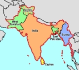
Pakistan was intended as a Muslim homeland, while the new India was secular with a Hindu
majority. Muslim-majority British provinces in the north were to become the foundation of Pakistan. The provinces of Baluchistan
(91.8% Muslim before partition) and Sindh (72.7%) were granted entirely to Pakistan. However, two provinces did not have an overwhelming majority -- Bengal
in the north-east (54.4% Muslim) and the Punjab
in the north-west (55.7% Muslim). The western part of the Punjab
became part of West Pakistan
and the eastern part became the Indian state of East Punjab, which was later divided between a smaller Punjab State
and two other states. Bengal was also partitioned, into East Bengal
(in Pakistan) and West Bengal
(in India). Following independence, the North-West Frontier Province
(whose borders with Afghanistan
had earlier been demarcated by the Durand Line
) voted in a referendum
to join Pakistan.
The Punjab's population distribution was such that there was no line that could neatly divide Hindus, Muslims, and Sikhs. Likewise, no line could appease the Muslim League, headed by Jinnah, and the Indian National Congress led by Nehru and Patel
, as well as the British. Moreover, any division based on religious communities was sure to entail "cutting through road and rail communications, irrigation schemes, electric power systems and even individual landholdings." However, a well-drawn line could minimize the separation of farmers from their fields, and also minimize the numbers of people who might feel forced to relocate.
As it turned out, on "the sub-continent as a whole, some 14 million people left their homes and set out by every means possible -- by air, train, and road, in cars and lorries, in buses and bullock carts, but most of all on foot -- to seek refuge with their own kind." Many of them were slaughtered by an opposing side, some starved or died of exhaustion, while others were afflicted with "cholera
, dysentery
, and all those other diseases that afflict undernourished refugees everywhere". Estimates of the number of people who died range between 200,000 (official British estimate at the time) and two million, with the consensus being around one million dead.
, the Viceroy of India prior to his replacement as Viceroy, in February 1947, by Lord Louis Mountbatten.
In order to determine exactly which territories to assign to each country, in June 1947, Britain appointed Sir Cyril Radcliffe to chair two Boundary Commissions—one for Bengal and one for Punjab.
The Commission was instructed to "demarcate the boundaries of the two parts of the Punjab on the basis of ascertaining the contiguous majority areas of Muslims and non-Muslims. In doing so, it will also take into account other factors." Other factors were undefined, giving Radcliffe leeway, but included decisions regarding "natural boundaries, communications, watercourses and irrigation systems", as well as socio-political consideration. Each commission also had 4 representatives—2 from the Indian National Congress
and 2 from the Muslim League. Given the deadlock between the interests of the two sides and their rancorous relationship, the final decision was essentially Radcliffe's.
After arriving in India on 8 July, Radcliffe was given just 5 weeks to decide on a border. He soon met with his college alumnus Mountbatten and travelled to Lahore
and Calcutta to meet with commission members, chiefly Nehru from the Congress and Jinnah, president of the Muslim League. He objected to the short time frame, but all parties were insistent that the line be finished by the 15 August British withdrawal from India. Mountbatten had accepted the post as Viceroy on the condition of an early deadline. The decision was completed just a couple of days before the withdrawal, but due to political manoeuvring, not published until 17 August, two days after the grant of independence to India and Pakistan.
In fact, minimizing the numbers of Hindus and Muslims on the wrong side of the line was not the only concern to balance. The Punjab Border Commission was to draw a border through the middle of an area home to the Sikh community. Lord Islay was rueful for the British not to give more consideration to the community who, in his words, had "provided many thousands of splendid recruits for the Indian Army" in its service for the crown in WWI. However, the Sikhs were militant in their opposition to any solution which would put their community in a Muslim ruled state. Moreover, many insisted on their own sovereign state, something no-one else would agree to.
Last of all, were the communities without any representation. The Bengal Border Commission representatives were chiefly concerned with the question of who would get Calcutta. The Buddhist tribes in the Chittigong Hill Tracts in Bengal had no official representation and were left totally without information to prepare for their situation until two days after the partition.
Perceiving the situation as intractable and urgent, Radcliffe went on to make all the difficult decisions himself. This was impossible from inception, but Radcliffe seems to have had no doubt in himself and raised no official complaint or proposal to change the circumstances.
No amount of knowledge could produce a line that would completely avoid conflict; already, "sectarian riots in Punjab and Bengal dimmed hopes for a quick and dignified British withdrawal". "Many of the seeds of postcolonial disorder in South Asia were sown much earlier, in two centuries of direct and indirect British rule, but, as book after book has demonstrated, nothing in the complex tragedy of partition was inevitable."
Radcliffe justified such casual division with the truism
that no matter what he did, people would suffer. The thinking behind this justification may never be known since Radcliffe "destroyed all his papers before he left India". He departed on Independence Day itself, before even the boundary awards were distributed. By his own admission, Radcliffe was heavily influenced by his lack of fitness for the Indian climate and his eagerness to depart India.
The implementation was no less hasty than the process of drawing the border. On 16 August 1947 at 5:00pm, the Indian and Pakistani representatives were given two hours to study copies, before the Radcliffe award was published on the 17th.
According to Read, there is some circumstantial evidence that Nehru and Patel were secretly informed of the Punjab Award's contents on August 9 or 10, either through Mountbatten or Radcliffe's Indian assistant secretary. Regardless of how it transpired, the award was changed to put a salient east of the Sutlej canal within India's domain instead of Pakistan's. This area consisted of two Muslim-majority tehsils with a combined population of over half a million. There were two apparent reasons for the switch: (1) the area housed an army arms depot and (2) contained the headwaters of a canal which irrigated the princely state
of Bikaner, which would accede to India.
Likewise, it is not known how Radcliffe was persuaded to award the Chittagong Hill Tracts
to Pakistan. This came as a shock to Patel and Nehru who had assumed the areas would be awarded to India since they were 98% non-Muslim. Similarly, the decision to award India the Muslim-majority districts of Murshidabad
and Malda in Bengal was kept so secret that the inhabitants hoisted the Pakistani flag there till the award was made public on 17 August 1947.
The truth of how these decisions were made may never be known, since Radcliffe destroyed all of his records and Mountbatten expressly denied any special-knowledge or favouritism.
to keep the peace around Lahore, but 50,000 men was not enough to prevent thousands of killings, 77% of which were in the rural areas. Given the size of the territory, the force amounted to less than 1 soldier per square mile. This was not enough to protect the cities much less the caravans of the hundreds of thousands of refugees who were fleeing their homes in what would become Pakistan.
Both India and Pakistan were loath to violate the agreement by supporting the rebellions of villages drawn on the wrong side of the border, as this could prompt a loss of face on the international stage and require the British or the UN to intervene. (This did not prevent them from getting into immediate conflict over the former princely state
of Kashmir
, as this territory was not a part of the Radcliffe agreement.) Ultimately, border conflicts led to three wars, in 1947
, 1965
, and 1971
, as well as the May 1998 dual tests of nuclear weapons and the Kargil conflict of 1999
.
and the Gurdaspur
District. Minor disputes evolved around the districts of Malda, Khulna
, and Murshidabad
of Bengal and the sub-division of Karimganj
of Assam.
On 15 August 1947, many of the tribes did not know to which side of the border they belonged. On 17 August, the publication of the Radcliffe Award put the CHTs in Pakistan. The rationale of giving the Chittagong Hill Tracts to Pakistan was that they were inaccessible to India and to provide some buffer area to Chittagong
(now in Bangladesh
), a major city and port; it was also argued that its only approach was through Chittagong.
"Two days later, the CHTPA resolved not to abide by the award and hoisted the Indian flag. The Pakistani army dealt with the protest but the problem has not yet been solved."
, the Gurdaspur district
was the northernmost district of the Punjab Province of British India. The district itself was administratively subdivided into four tehsils: Shakargarh, Gurdaspur, Batala, and Pathankot. Of the four, only Shakargarh Tehsil, which was separated from the rest of the district by the Ravi river
, was awarded to Pakistan and became part of Sialkot District within the West Punjab
province of Pakistan. The rest of the district, retaining the name Gurdaspur, became part of India's East Punjab state. The division of the district was followed by a population transfer between the two nations, with Muslims leaving for Pakistan and Hindus and Sikhs leaving for India.
The entire district of Gurdaspur had a plurality of Muslims, which was a majority
when counting the Ahmadiyya
community as Muslim. Ahmadiyya were counted as Muslim even though they had been declared non-Muslim by Muslim clergy. The district was home to a large concentration of Ahmadiyyas, their cultural centres, and their spiritual centre Qadian
. In the 1901 census, the population of Gurdaspur district was 49% Muslim, 40% Hindu, and 10% Sikh. At the time of partition, the census showed the following distribution of Muslims and non-Muslims:
It has been speculated that the following arguments were made before the boundary commission by Lord Mountbatten and others in favour of awarding much of Gurdaspur to India:
and Zira tehsils in Firozpur district
to Pakistan. This was opposed by the Maharaja of Bikaner because Harike headworks on the confluence of the Satluj and Beas
rivers, from where a canal originated, the only source of water for his desert state was in Ferozepore. It was only after he threatened Mountbatten, that he would accede his state to Pakistan if Firozpur was awarded to West Punjab, that the award was changed at the last minute and all of Firozpur district was awarded to India.
. The district overall had a slight Muslim majority, but was divided and most of it, including Malda town, went to India. The district remained under East Pakistan administration for 3–4 days after 15 August 1947. It was only when the award was made public that the Pakistani flag was replaced by the Indian flag in Malda.
with a slight Hindu majority of 52% was also given to East Pakistan in lieu of the much smaller Murshidabad district
with a 70% Muslim majority, which went to India.
district of Assam
joined Pakistan in accordance with a plebiscite. However, the Karimganj
sub-division with a Muslim majority was severed from Sylhet and given to India. As of the 2001 Indian Census, Karimganj has a Muslim majority of 52.3%.
Demarcation line
A demarcation line means simply a boundary around a specific area, but is commonly used to denote a temporary geopolitical border, often agreed upon as part of an armistice or ceasefire.See the following examples:...
between India
India
India , officially the Republic of India , is a country in South Asia. It is the seventh-largest country by geographical area, the second-most populous country with over 1.2 billion people, and the most populous democracy in the world...
and Pakistan
Pakistan
Pakistan , officially the Islamic Republic of Pakistan is a sovereign state in South Asia. It has a coastline along the Arabian Sea and the Gulf of Oman in the south and is bordered by Afghanistan and Iran in the west, India in the east and China in the far northeast. In the north, Tajikistan...
upon the Partition of India
Partition of India
The Partition of India was the partition of British India on the basis of religious demographics that led to the creation of the sovereign states of the Dominion of Pakistan and the Union of India on 14 and 15...
. The Radcliffe Line was named after its architect, Sir Cyril Radcliffe
Cyril Radcliffe, 1st Viscount Radcliffe
Cyril John Radcliffe, 1st Viscount Radcliffe GBE, PC, QC was a British lawyer and Law Lord most famous for his partitioning of the British Imperial territory of India.-Background, education and early career:...
, who as chair of the Border Commissions was tasked with equitably dividing 175000 square miles (453,247.9 km²) of territory with 88 million people.
Background
On July 15, 1947, the Indian Independence Act 1947Indian Independence Act 1947
The Indian Independence Act 1947 was as an Act of the Parliament of the United Kingdom that partitioned British India into the two new independent dominions of India and Pakistan...
of the Parliament of the United Kingdom
Parliament of the United Kingdom
The Parliament of the United Kingdom of Great Britain and Northern Ireland is the supreme legislative body in the United Kingdom, British Crown dependencies and British overseas territories, located in London...
stipulated that British rule
British Raj
British Raj was the British rule in the Indian subcontinent between 1858 and 1947; The term can also refer to the period of dominion...
in India would come to an end just one month later, on August 15, 1947. The Act also stipulated the partition of the Provinces of British India into two new sovereign dominion
Dominion
A dominion, often Dominion, refers to one of a group of autonomous polities that were nominally under British sovereignty, constituting the British Empire and British Commonwealth, beginning in the latter part of the 19th century. They have included Canada, Australia, New Zealand, Newfoundland,...
s: the Union of India and the Dominion of Pakistan
Dominion of Pakistan
The Dominion of Pakistan was an independent federal Commonwealth realm in South Asia that was established in 1947 on the partition of British India into two sovereign dominions . The Dominion of Pakistan, which included modern-day Pakistan and Bangladesh, was intended to be a homeland for the...
.
Before partition, some 40% of the area of India was covered by princely state
Princely state
A Princely State was a nominally sovereign entitity of British rule in India that was not directly governed by the British, but rather by an Indian ruler under a form of indirect rule such as suzerainty or paramountcy.-British relationship with the Princely States:India under the British Raj ...
s. These states were in subsidiary alliance
Subsidiary alliance
A subsidiary alliance is an alliance between a dominant nation and a nation that it dominates.-British policy in India:The doctrine of subsidiary alliance was introduced by Marquess Wellesley, British Governor-General of India from 1798 to 1805...
s with the British, who were responsible for their external affairs, but they were not British possessions and did not form part of British India. Thus, the British could not grant them independence, nor partition them. The Indian Independence Act abandoned the suzerainty
Suzerainty
Suzerainty occurs where a region or people is a tributary to a more powerful entity which controls its foreign affairs while allowing the tributary vassal state some limited domestic autonomy. The dominant entity in the suzerainty relationship, or the more powerful entity itself, is called a...
of the British Crown over the princely states and dissolved the Indian Empire, so that the rulers of the states found themselves fully independent and were free to decide for themselves whether to accede
Instrument of Accession
The Instrument of Accession was a legal document created in 1947 to enable each of the rulers of the princely states under British suzerainty to join one of the new dominions of India or Pakistan created by the Partition of British India.-Background:...
to one of the new dominions or to remain independent. In the event, almost all decided quickly to join India or Pakistan. A small number did not.
Pakistan was intended as a Muslim homeland, while the new India was secular with a Hindu
Hindu
Hindu refers to an identity associated with the philosophical, religious and cultural systems that are indigenous to the Indian subcontinent. As used in the Constitution of India, the word "Hindu" is also attributed to all persons professing any Indian religion...
majority. Muslim-majority British provinces in the north were to become the foundation of Pakistan. The provinces of Baluchistan
Balochistan (Pakistan)
Balochistan is one of the four provinces or federating units of Pakistan. With an area of 134,051 mi2 or , it is the largest province of Pakistan, constituting approximately 44% of the total land mass of Pakistan. According to the 1998 population census, Balochistan had a population of...
(91.8% Muslim before partition) and Sindh (72.7%) were granted entirely to Pakistan. However, two provinces did not have an overwhelming majority -- Bengal
Bengal
Bengal is a historical and geographical region in the northeast region of the Indian Subcontinent at the apex of the Bay of Bengal. Today, it is mainly divided between the sovereign land of People's Republic of Bangladesh and the Indian state of West Bengal, although some regions of the previous...
in the north-east (54.4% Muslim) and the Punjab
Punjab region
The Punjab , also spelled Panjab |water]]s"), is a geographical region straddling the border between Pakistan and India which includes Punjab province in Pakistan and the states of the Punjab, Haryana, Himachal Pradesh, Chandigarh and some northern parts of the National Capital Territory of Delhi...
in the north-west (55.7% Muslim). The western part of the Punjab
Punjab (British India)
Punjab was a province of British India, it was one of the last areas of the Indian subcontinent to fall under British rule. With the end of British rule in 1947 the province was split between West Punjab, which went to Pakistan, and East Punjab, which went to India...
became part of West Pakistan
West Pakistan
West Pakistan , common name West-Pakistan , in the period between its establishment on 22 November 1955 to disintegration on December 16, 1971. This period, during which, Pakistan was divided, ended when East-Pakistan was disintegrated and succeeded to become which is now what is known as Bangladesh...
and the eastern part became the Indian state of East Punjab, which was later divided between a smaller Punjab State
Punjab (India)
Punjab ) is a state in the northwest of the Republic of India, forming part of the larger Punjab region. The state is bordered by the Indian states of Himachal Pradesh to the east, Haryana to the south and southeast and Rajasthan to the southwest as well as the Pakistani province of Punjab to the...
and two other states. Bengal was also partitioned, into East Bengal
East Bengal
East Bengal was the name used during two periods in the 20th century for a territory that roughly corresponded to the modern state of Bangladesh. Both instances involved a violent partition of Bengal....
(in Pakistan) and West Bengal
West Bengal
West Bengal is a state in the eastern region of India and is the nation's fourth-most populous. It is also the seventh-most populous sub-national entity in the world, with over 91 million inhabitants. A major agricultural producer, West Bengal is the sixth-largest contributor to India's GDP...
(in India). Following independence, the North-West Frontier Province
North-West Frontier Province
Khyber Pakhtunkhwa , formerly known as the North-West Frontier Province and various other names, is one of the four provinces of Pakistan, located in the north-west of the country...
(whose borders with Afghanistan
Afghanistan
Afghanistan , officially the Islamic Republic of Afghanistan, is a landlocked country located in the centre of Asia, forming South Asia, Central Asia and the Middle East. With a population of about 29 million, it has an area of , making it the 42nd most populous and 41st largest nation in the world...
had earlier been demarcated by the Durand Line
Durand Line
The Durand Line refers to the porous international border between Pakistan and Afghanistan, which has divided the ethnic Pashtuns . This poorly marked line is approximately long...
) voted in a referendum
Referendum
A referendum is a direct vote in which an entire electorate is asked to either accept or reject a particular proposal. This may result in the adoption of a new constitution, a constitutional amendment, a law, the recall of an elected official or simply a specific government policy. It is a form of...
to join Pakistan.
The Punjab's population distribution was such that there was no line that could neatly divide Hindus, Muslims, and Sikhs. Likewise, no line could appease the Muslim League, headed by Jinnah, and the Indian National Congress led by Nehru and Patel
Patel
Patel is a surname of Indian origin, originally meaning "headman" or"village chief". Patels are socially, economically and politically the most dominant caste in Gujarat Patels are basically Kurmis or Kunbis and are found in various geographical locations. The Kunbi are an Indian subcaste...
, as well as the British. Moreover, any division based on religious communities was sure to entail "cutting through road and rail communications, irrigation schemes, electric power systems and even individual landholdings." However, a well-drawn line could minimize the separation of farmers from their fields, and also minimize the numbers of people who might feel forced to relocate.
As it turned out, on "the sub-continent as a whole, some 14 million people left their homes and set out by every means possible -- by air, train, and road, in cars and lorries, in buses and bullock carts, but most of all on foot -- to seek refuge with their own kind." Many of them were slaughtered by an opposing side, some starved or died of exhaustion, while others were afflicted with "cholera
Cholera
Cholera is an infection of the small intestine that is caused by the bacterium Vibrio cholerae. The main symptoms are profuse watery diarrhea and vomiting. Transmission occurs primarily by drinking or eating water or food that has been contaminated by the diarrhea of an infected person or the feces...
, dysentery
Dysentery
Dysentery is an inflammatory disorder of the intestine, especially of the colon, that results in severe diarrhea containing mucus and/or blood in the faeces with fever and abdominal pain. If left untreated, dysentery can be fatal.There are differences between dysentery and normal bloody diarrhoea...
, and all those other diseases that afflict undernourished refugees everywhere". Estimates of the number of people who died range between 200,000 (official British estimate at the time) and two million, with the consensus being around one million dead.
Process and key people
A crude border had already been drawn up by Lord WavellArchibald Wavell, 1st Earl Wavell
Field Marshal Archibald Percival Wavell, 1st Earl Wavell GCB, GCSI, GCIE, CMG, MC, PC was a British field marshal and the commander of British Army forces in the Middle East during the Second World War. He led British forces to victory over the Italians, only to be defeated by the German army...
, the Viceroy of India prior to his replacement as Viceroy, in February 1947, by Lord Louis Mountbatten.
Louis Mountbatten, 1st Earl Mountbatten of Burma
Admiral of the Fleet Louis Francis Albert Victor Nicholas George Mountbatten, 1st Earl Mountbatten of Burma, KG, GCB, OM, GCSI, GCIE, GCVO, DSO, PC, FRS , was a British statesman and naval officer, and an uncle of Prince Philip, Duke of Edinburgh...
In order to determine exactly which territories to assign to each country, in June 1947, Britain appointed Sir Cyril Radcliffe to chair two Boundary Commissions—one for Bengal and one for Punjab.
The Commission was instructed to "demarcate the boundaries of the two parts of the Punjab on the basis of ascertaining the contiguous majority areas of Muslims and non-Muslims. In doing so, it will also take into account other factors." Other factors were undefined, giving Radcliffe leeway, but included decisions regarding "natural boundaries, communications, watercourses and irrigation systems", as well as socio-political consideration. Each commission also had 4 representatives—2 from the Indian National Congress
Indian National Congress
The Indian National Congress is one of the two major political parties in India, the other being the Bharatiya Janata Party. It is the largest and one of the oldest democratic political parties in the world. The party's modern liberal platform is largely considered center-left in the Indian...
and 2 from the Muslim League. Given the deadlock between the interests of the two sides and their rancorous relationship, the final decision was essentially Radcliffe's.
After arriving in India on 8 July, Radcliffe was given just 5 weeks to decide on a border. He soon met with his college alumnus Mountbatten and travelled to Lahore
Lahore
Lahore is the capital of the Pakistani province of Punjab and the second largest city in the country. With a rich and fabulous history dating back to over a thousand years ago, Lahore is no doubt Pakistan's cultural capital. One of the most densely populated cities in the world, Lahore remains a...
and Calcutta to meet with commission members, chiefly Nehru from the Congress and Jinnah, president of the Muslim League. He objected to the short time frame, but all parties were insistent that the line be finished by the 15 August British withdrawal from India. Mountbatten had accepted the post as Viceroy on the condition of an early deadline. The decision was completed just a couple of days before the withdrawal, but due to political manoeuvring, not published until 17 August, two days after the grant of independence to India and Pakistan.
Boundary-making procedures
All lawyers by trade, Radcliffe and the other commissioners had all of the polish and none of the specialized knowledge needed for the task. They had no advisers to inform them of the well-established procedures and information needed to draw a boundary. Nor was there time to gather the survey and regional information. The absence of some experts and advisers, such as the United Nations, was deliberate, to avoid delay. Britain's new Labour government "deep in wartime debt, simply couldn’t afford to hold on to its increasingly unstable empire." "The absence of outside participants—for example, from the United Nations—also satisfied the British Government's urgent desire to save face by avoiding the appearance that it required outside help to govern—or stop governing—its own empire."Political representation
The equal representation given to politicians from Indian National Congress and the Muslim League appeared to provide balance, but instead created deadlock. The relationships were so tendentious that the judges "could hardly bear to speak to each other", and the agendas so at odds that there seemed to be little point anyway. Even worse, "the wife and two children of the Sikh judge in Lahore had been murdered by Muslims in Rawalpindi a few weeks earlier."In fact, minimizing the numbers of Hindus and Muslims on the wrong side of the line was not the only concern to balance. The Punjab Border Commission was to draw a border through the middle of an area home to the Sikh community. Lord Islay was rueful for the British not to give more consideration to the community who, in his words, had "provided many thousands of splendid recruits for the Indian Army" in its service for the crown in WWI. However, the Sikhs were militant in their opposition to any solution which would put their community in a Muslim ruled state. Moreover, many insisted on their own sovereign state, something no-one else would agree to.
Last of all, were the communities without any representation. The Bengal Border Commission representatives were chiefly concerned with the question of who would get Calcutta. The Buddhist tribes in the Chittigong Hill Tracts in Bengal had no official representation and were left totally without information to prepare for their situation until two days after the partition.
Perceiving the situation as intractable and urgent, Radcliffe went on to make all the difficult decisions himself. This was impossible from inception, but Radcliffe seems to have had no doubt in himself and raised no official complaint or proposal to change the circumstances.
Local knowledge
Before his appointment, Radcliffe had never visited India and knew no one there. To the British and the feuding politicians alike, this liability was looked upon as an asset; he was considered to be unbiased toward any of the parties, except of course Britain. Only his private secretary, Christopher Beaumont, was familiar with the administration and life in the Punjab. Wanting to preserve the appearance of impartiality, Radcliffe also kept his distance from Viceroy Mountbatten.No amount of knowledge could produce a line that would completely avoid conflict; already, "sectarian riots in Punjab and Bengal dimmed hopes for a quick and dignified British withdrawal". "Many of the seeds of postcolonial disorder in South Asia were sown much earlier, in two centuries of direct and indirect British rule, but, as book after book has demonstrated, nothing in the complex tragedy of partition was inevitable."
Haste and indifference
Had the Commission been more careful, gaffes in the division could have been avoided. For example, there were instances where the border was drawn leaving some parts of a village in India and some in Pakistan. Since he had just a month, Radcliffe saw little point in being careful to skirt villages. His border was drawn right through thickly populated areas instead of between them. There were even instances where the dividing line passed through a single house with some rooms in one country and others in the other.Radcliffe justified such casual division with the truism
Truism
A truism is a claim that is so obvious or self-evident as to be hardly worth mentioning, except as a reminder or as a rhetorical or literary device and is the opposite of falsism....
that no matter what he did, people would suffer. The thinking behind this justification may never be known since Radcliffe "destroyed all his papers before he left India". He departed on Independence Day itself, before even the boundary awards were distributed. By his own admission, Radcliffe was heavily influenced by his lack of fitness for the Indian climate and his eagerness to depart India.
The implementation was no less hasty than the process of drawing the border. On 16 August 1947 at 5:00pm, the Indian and Pakistani representatives were given two hours to study copies, before the Radcliffe award was published on the 17th.
Secrecy
To avoid disputes and delays, the division was done in secret. The final Awards were ready on 9 August and the 12 August, but not published until two days after the partition.According to Read, there is some circumstantial evidence that Nehru and Patel were secretly informed of the Punjab Award's contents on August 9 or 10, either through Mountbatten or Radcliffe's Indian assistant secretary. Regardless of how it transpired, the award was changed to put a salient east of the Sutlej canal within India's domain instead of Pakistan's. This area consisted of two Muslim-majority tehsils with a combined population of over half a million. There were two apparent reasons for the switch: (1) the area housed an army arms depot and (2) contained the headwaters of a canal which irrigated the princely state
Princely state
A Princely State was a nominally sovereign entitity of British rule in India that was not directly governed by the British, but rather by an Indian ruler under a form of indirect rule such as suzerainty or paramountcy.-British relationship with the Princely States:India under the British Raj ...
of Bikaner, which would accede to India.
Likewise, it is not known how Radcliffe was persuaded to award the Chittagong Hill Tracts
Chittagong Hill Tracts
The Chittagong Hill Tracts comprise an area of 13,295 km2 in south-eastern Bangladesh, and borders India and Myanmar . It was a single district of Bangladesh until 1984. In that year it was divided into three separate districts: Khagrachari, Rangamati and Bandarban. Topographically, this is the...
to Pakistan. This came as a shock to Patel and Nehru who had assumed the areas would be awarded to India since they were 98% non-Muslim. Similarly, the decision to award India the Muslim-majority districts of Murshidabad
Murshidabad
Murshidabad is a city in Murshidabad district of West Bengal state in India. The city of Murshidabad is located on the southern bank of the Bhagirathi, a distributary of the Ganges River. It was the capital of undivided Bengal during the Mughal rule. Nawabs of Bengal used to rule Bengal from this...
and Malda in Bengal was kept so secret that the inhabitants hoisted the Pakistani flag there till the award was made public on 17 August 1947.
The truth of how these decisions were made may never be known, since Radcliffe destroyed all of his records and Mountbatten expressly denied any special-knowledge or favouritism.
Implementation
After the partition, the fledgling governments of India and Pakistan were left with all responsibility to implement the border. After visiting Lahore in August, Viceroy Mountbatten hastily arranged a Punjab Boundary ForcePunjab Boundary Force
The Punjab Boundary Force was an ad hoc military force to restore law and order during the communal carnages of the partition of India in the Punjab. The force was based on the 4th Indian Division and commanded by Maj Gen T.W. Rees...
to keep the peace around Lahore, but 50,000 men was not enough to prevent thousands of killings, 77% of which were in the rural areas. Given the size of the territory, the force amounted to less than 1 soldier per square mile. This was not enough to protect the cities much less the caravans of the hundreds of thousands of refugees who were fleeing their homes in what would become Pakistan.
Both India and Pakistan were loath to violate the agreement by supporting the rebellions of villages drawn on the wrong side of the border, as this could prompt a loss of face on the international stage and require the British or the UN to intervene. (This did not prevent them from getting into immediate conflict over the former princely state
Princely state
A Princely State was a nominally sovereign entitity of British rule in India that was not directly governed by the British, but rather by an Indian ruler under a form of indirect rule such as suzerainty or paramountcy.-British relationship with the Princely States:India under the British Raj ...
of Kashmir
Kashmir
Kashmir is the northwestern region of the Indian subcontinent. Until the mid-19th century, the term Kashmir geographically denoted only the valley between the Great Himalayas and the Pir Panjal mountain range...
, as this territory was not a part of the Radcliffe agreement.) Ultimately, border conflicts led to three wars, in 1947
Indo-Pakistani War of 1947
The India-Pakistan War of 1947-48, sometimes known as the First Kashmir War, was fought between India and Pakistan over the princely state of Kashmir and Jammu from 1947 to 1948. It was the first of four wars fought between the two newly independent nations...
, 1965
Indo-Pakistani War of 1965
The Indo-Pakistani War of 1965 was a culmination of skirmishes that took place between April 1965 and September 1965 between Pakistan and India. This conflict became known as the Second Kashmir War fought by India and Pakistan over the disputed region of Kashmir, the first having been fought in 1947...
, and 1971
Indo-Pakistani War of 1971
The Indo-Pakistani War of 1971 was a military conflict between India and Pakistan. Indian, Bangladeshi and international sources consider the beginning of the war to be Operation Chengiz Khan, Pakistan's December 3, 1971 pre-emptive strike on 11 Indian airbases...
, as well as the May 1998 dual tests of nuclear weapons and the Kargil conflict of 1999
Kargil War
The Kargil War ,, also known as the Kargil conflict, was an armed conflict between India and Pakistan that took place between May and July 1999 in the Kargil district of Kashmir and elsewhere along the Line of Control...
.
Disputes along the Radcliffe Line
There were two major disputes regarding the Radcliffe Line, the Chittagong Hill TractsChittagong Hill Tracts
The Chittagong Hill Tracts comprise an area of 13,295 km2 in south-eastern Bangladesh, and borders India and Myanmar . It was a single district of Bangladesh until 1984. In that year it was divided into three separate districts: Khagrachari, Rangamati and Bandarban. Topographically, this is the...
and the Gurdaspur
Gurdaspur
Gurdaspur is a city in the state of Punjab, situated in the northwest part of the Republic of India. It is located in the center of and is the administrative head of Gurdaspur District. It was the location of a fort which was famous for the siege it sustained in 1712 from the Mughals...
District. Minor disputes evolved around the districts of Malda, Khulna
Khulna
Khulna is the third largest city in Bangladesh. It is located on the banks of the Rupsha and Bhairab rivers in Khulna District. It is the divisional headquarters of Khulna Division and a major industrial and commercial center. It has a seaport named Mongla on its outskirts, 38 km from Khulna...
, and Murshidabad
Murshidabad
Murshidabad is a city in Murshidabad district of West Bengal state in India. The city of Murshidabad is located on the southern bank of the Bhagirathi, a distributary of the Ganges River. It was the capital of undivided Bengal during the Mughal rule. Nawabs of Bengal used to rule Bengal from this...
of Bengal and the sub-division of Karimganj
Karimganj
Karimganj Town is a town in the Karimganj District of the Indian state of Assam. It is the administrative headquarter and main town of the district.-Geography:...
of Assam.
Chittagong Hill Tracts
Chittagong Hill Tracts had a majority non-Muslim population of 97% (most of them Buddhists), but was given to Pakistan. The Chittagong Hill Tracts People's Association (CHTPA) petitioned the Bengal Boundary Commission that, since the CHTs were inhabited largely by non-Muslims, they should remain within India. Since they had no official representation, there was no official discussion on the matter, and many on the Indian side assumed the CHT would be awarded to India.On 15 August 1947, many of the tribes did not know to which side of the border they belonged. On 17 August, the publication of the Radcliffe Award put the CHTs in Pakistan. The rationale of giving the Chittagong Hill Tracts to Pakistan was that they were inaccessible to India and to provide some buffer area to Chittagong
Chittagong
Chittagong ) is a city in southeastern Bangladesh and the capital of an eponymous district and division. Built on the banks of the Karnaphuli River, the city is home to Bangladesh's busiest seaport and has a population of over 4.5 million, making it the second largest city in the country.A trading...
(now in Bangladesh
Bangladesh
Bangladesh , officially the People's Republic of Bangladesh is a sovereign state located in South Asia. It is bordered by India on all sides except for a small border with Burma to the far southeast and by the Bay of Bengal to the south...
), a major city and port; it was also argued that its only approach was through Chittagong.
"Two days later, the CHTPA resolved not to abide by the award and hoisted the Indian flag. The Pakistani army dealt with the protest but the problem has not yet been solved."
Gurdaspur District
Under British ruleBritish Raj
British Raj was the British rule in the Indian subcontinent between 1858 and 1947; The term can also refer to the period of dominion...
, the Gurdaspur district
Gurdaspur District
Gurdaspur district is a district in the state of Punjab, situated in the northwest part of the Republic of India. Gurdaspur is the district headquarters. It internationally borders Narowal District of the Pakistani Punjab, Kathua District of Jammu and Kashmir, the Punjab districts of Amritsar and...
was the northernmost district of the Punjab Province of British India. The district itself was administratively subdivided into four tehsils: Shakargarh, Gurdaspur, Batala, and Pathankot. Of the four, only Shakargarh Tehsil, which was separated from the rest of the district by the Ravi river
Ravi River
The Ravi is a trans-boundary river flowing through Northwestern India and eastern Pakistan. It is one of the six rivers of the Indus System in Punjab region ....
, was awarded to Pakistan and became part of Sialkot District within the West Punjab
West Punjab
West Punjab was a province of Pakistan from 1947 to 1955. The province covered an area of 160,622 km², including much of the current Punjab province and the Islamabad Capital Territory, but excluding the former princely state of Bahawalpur. The capital was the city of Lahore and the province...
province of Pakistan. The rest of the district, retaining the name Gurdaspur, became part of India's East Punjab state. The division of the district was followed by a population transfer between the two nations, with Muslims leaving for Pakistan and Hindus and Sikhs leaving for India.
The entire district of Gurdaspur had a plurality of Muslims, which was a majority
Majority
A majority is a subset of a group consisting of more than half of its members. This can be compared to a plurality, which is a subset larger than any other subset; i.e. a plurality is not necessarily a majority as the largest subset may consist of less than half the group's population...
when counting the Ahmadiyya
Ahmadiyya
Ahmadiyya is an Islamic religious revivalist movement founded in India near the end of the 19th century, originating with the life and teachings of Mirza Ghulam Ahmad , who claimed to have fulfilled the prophecies about the world reformer of the end times, who was to herald the Eschaton as...
community as Muslim. Ahmadiyya were counted as Muslim even though they had been declared non-Muslim by Muslim clergy. The district was home to a large concentration of Ahmadiyyas, their cultural centres, and their spiritual centre Qadian
Qadian
Qadian is a small town and a municipal council in Gurdaspur District, north-east of Amritsar, situated north-east of Batala city in the state of Punjab, India....
. In the 1901 census, the population of Gurdaspur district was 49% Muslim, 40% Hindu, and 10% Sikh. At the time of partition, the census showed the following distribution of Muslims and non-Muslims:
| Part of district | Majority | |
|---|---|---|
| Shakargarh Shakargarh Shakargarh , the headquarters of Shakargarh Tehsil, is a city in the north-east of Narowal District, Punjab, Pakistan. It borders Jammu to the North and Sialkot to the west The city is located at 32°16'0N 75°10'0E and is situated at the west bank of the Ravi River.-Demographics:The total area of... tehsil |
Muslim | 51% |
| Gurdaspur Gurdaspur Gurdaspur is a city in the state of Punjab, situated in the northwest part of the Republic of India. It is located in the center of and is the administrative head of Gurdaspur District. It was the location of a fort which was famous for the siege it sustained in 1712 from the Mughals... tehsil |
Muslim | 51% |
| Batala Batala Batala is a municipal council in Gurdaspur district in the state of Punjab, India. It is located about 30 km from Gurdaspur, the headquarters of the district.... tehsil |
Muslim | 53% |
| Pathankot Pathankot Pathankot became 22nd district on 28th July 2011 and a municipal corporation in the Indian state of Punjab. It was a part of the Nurpur princely state ruled by the Rajputs prior to 1849 AD. It is a meeting point of the three northern states of Punjab, Himachal Pradesh and Jammu and Kashmir... tehsil |
non-Muslim | 33% |
| Entire District (all four tehsils) | Muslim | 50.6% |
| Area awarded to India | non-Muslim | less than 50% |
It has been speculated that the following arguments were made before the boundary commission by Lord Mountbatten and others in favour of awarding much of Gurdaspur to India:
- The territory would allow the kingdom of KashmirKashmirKashmir is the northwestern region of the Indian subcontinent. Until the mid-19th century, the term Kashmir geographically denoted only the valley between the Great Himalayas and the Pir Panjal mountain range...
to be contiguously accessible to India, so that its ruler could opt to integrate with the Indian Union. - Pathankot tehsil contained a direct railway link with the adjoining HoshiarpurHoshiarpur DistrictHoshiarpur District , is a district of Punjab state in northern India.In 2011, Hoshiarpur had population of 1,582,793 of which male and female were 806,921 and 775,872 respectively. There was change of 6.85 percent in the population compared to population as per 2001...
and KangraKangra districtKangra is the most populous district of the state of Himachal Pradesh, India. Dharamsala is the administrative headquarters of the district.-Geography:Kangra district of Himachal Pradesh is situated in Western Himalayas between 31°2 to...
districts of East PunjabEast PunjabEast Punjab was the part of the Punjab region that went to India following the Partition of the Punjab Province of British India between India and Pakistan in 1947...
. - Batala and Gurdaspur tehsils would provide a buffer to the Sikh holy city of AmritsarAmritsarAmritsar is a city in the northern part of India and is the administrative headquarters of Amritsar district in the state of Punjab, India. The 2001 Indian census reported the population of the city to be over 1,500,000, with that of the entire district numbering 3,695,077...
, whose district would otherwise be surrounded by Pakistani territories on three of its four sides. - If the area east of the Ravi river was considered as one block, it would have a slight non-Muslim majority. This block would consist of Amritsar and most of Gurdaspur district (excluding Shakargarh).
- Also, by doing this, the majority of the Sikh population (58%) would fall into East Punjab; by doing the opposite, a slight majority would be left in Pakistan and this would increase the number of Sikh refugees.
- This could help pacify the Sikh population who lost major tracts of lands in West PunjabWest PunjabWest Punjab was a province of Pakistan from 1947 to 1955. The province covered an area of 160,622 km², including much of the current Punjab province and the Islamabad Capital Territory, but excluding the former princely state of Bahawalpur. The capital was the city of Lahore and the province...
.
Firozpur District
To counter-balance the relatively small share of Gurdaspur district awarded to Pakistan, Radcliffe attempted to instead transfer FirozpurFirozpur
Firozpur is a city on the banks of the Sutlej River in Firozpur District, Punjab, India, founded by Sultan Firoz Shah Tughlaq , a Muslim ruler of the Tughlaq Dynasty who reigned over the Sultanate of Delhi from 1351 to 1388.The Manj Rajputs say the town was named after their chief, a Rajput of...
and Zira tehsils in Firozpur district
Firozpur District
Ferozepur district is one of the twenty two th districts in the state of Punjab in North-West Republic of India.It comprises an area of 11,142 km². The surface is level, with the exception of a few sand-hills in the south and south-east...
to Pakistan. This was opposed by the Maharaja of Bikaner because Harike headworks on the confluence of the Satluj and Beas
Beas River
The Beas River is a river in the northern part of India. The river rises in the Himalayas in central Himachal Pradesh, India, and flows for some 470 km to the Sutlej River in the Indian state of Punjab....
rivers, from where a canal originated, the only source of water for his desert state was in Ferozepore. It was only after he threatened Mountbatten, that he would accede his state to Pakistan if Firozpur was awarded to West Punjab, that the award was changed at the last minute and all of Firozpur district was awarded to India.
Malda District
Another disputed decision made by Radcliffe was division of the Malda district of BengalBengal
Bengal is a historical and geographical region in the northeast region of the Indian Subcontinent at the apex of the Bay of Bengal. Today, it is mainly divided between the sovereign land of People's Republic of Bangladesh and the Indian state of West Bengal, although some regions of the previous...
. The district overall had a slight Muslim majority, but was divided and most of it, including Malda town, went to India. The district remained under East Pakistan administration for 3–4 days after 15 August 1947. It was only when the award was made public that the Pakistani flag was replaced by the Indian flag in Malda.
Khulna & Murshidabad Districts
The entire Khulna DistrictKhulna District
The district of Khulna consists 10859 mosques, 680 temples, 81 churches, 15 Buddhist temples and 9 tombs.-Places of interest:*The Sundarbans is the largest mangrove forest in the world. The royal Bengal tiger inhabits the area; it is said that seeing the tiger enables a person to understand what a...
with a slight Hindu majority of 52% was also given to East Pakistan in lieu of the much smaller Murshidabad district
Murshidabad district
Murshidabad district is a district of West Bengal in eastern India. Situated on the left bank of the river Ganges, the district is very fertile. Covering an area of 5,341 km² and having a population 5.863m it is a densely populated district and the ninth most populous in India...
with a 70% Muslim majority, which went to India.
Karimganj
SylhetSylhet
Sylhet , is a major city in north-eastern Bangladesh. It is the main city of Sylhet Division and Sylhet District, and was granted metropolitan city status in March 2009. Sylhet is located on the banks of the Surma Valley and is surrounded by the Jaintia, Khasi and Tripura hills...
district of Assam
Assam
Assam , also, rarely, Assam Valley and formerly the Assam Province , is a northeastern state of India and is one of the most culturally and geographically distinct regions of the country...
joined Pakistan in accordance with a plebiscite. However, the Karimganj
Karimganj
Karimganj Town is a town in the Karimganj District of the Indian state of Assam. It is the administrative headquarter and main town of the district.-Geography:...
sub-division with a Muslim majority was severed from Sylhet and given to India. As of the 2001 Indian Census, Karimganj has a Muslim majority of 52.3%.
See also
- Partition of IndiaPartition of IndiaThe Partition of India was the partition of British India on the basis of religious demographics that led to the creation of the sovereign states of the Dominion of Pakistan and the Union of India on 14 and 15...
- Durand LineDurand LineThe Durand Line refers to the porous international border between Pakistan and Afghanistan, which has divided the ethnic Pashtuns . This poorly marked line is approximately long...
- McMahon LineMcMahon LineThe McMahon Line is a line agreed to by Great Britain and Tibet as part of Simla Accord, a treaty signed in 1914. Although its legal status is disputed by China, it is the effective boundary between China and India....
- PolandPolandPoland , officially the Republic of Poland , is a country in Central Europe bordered by Germany to the west; the Czech Republic and Slovakia to the south; Ukraine, Belarus and Lithuania to the east; and the Baltic Sea and Kaliningrad Oblast, a Russian exclave, to the north...
’s Curzon lineCurzon LineThe Curzon Line was put forward by the Allied Supreme Council after World War I as a demarcation line between the Second Polish Republic and Bolshevik Russia and was supposed to serve as the basis for a future border. In the wake of World War I, which catalysed the Russian Revolution of 1917, the...
Further reading
- India: Volume XI: The Mountbatten Viceroyalty-Announcement and Reception of the 3 June Plan, 31 May-7 July 1947. Reviewed by Wood, J.R. "Dividing the Jewel: Mountbatten and the Transfer of Power to India and Pakistan". Pacific Affairs, Vol. 58, No. 4 (Winter, 1985–1986), pp. 653–662. JSTOR
- Berg, E., and van Houtum, H. Routing borders between territories, discourses, and practices (p.128).
- Chester, Lucy P. Borders and Conflict in South Asia: The Radcliffe Boundary Commission and the Partition of Punjab. Manchester UP, 2009.
- Collins, L., and Lapierre, D. (1975) Freedom at MidnightFreedom at MidnightFreedom at Midnight is a book by Larry Collins and Dominique Lapierre. It describes the events in the Indian independence movement in 1947-48, beginning with the appointment of Lord Mountbatten of Burma as the last viceroy of British India, and ending with the death and funeral of Mahatma...
. - Collins, L., and Lapierre, D. Mountbatten and the Partition of India.
- Mishra, P. "Exit Wounds". The New Yorker, August 13, 2007. Retrieved from link.
- Moon, P. The Transfer of Power, 1942-7: Constitutional Relations Between Britain and India: Volume X: The Mountbatten Viceroyalty-Formulation of a Plan, 22 March-30 May 1947. Review "Dividing the Jewel" at JSTOR
- Moon, Blake, D., and Ashton, S. The Transfer of Power, 1942-7: Constitutional Relations Between Britain and. Review "Dividing the Jewel" at JSTOR
- Tunzelmann, A. Indian Summer. Henry Holt.
- Wolpert, S. (1989). A New History of India, 3rd ed. New York: Oxford University Press.