

R774 road
Encyclopedia
Regional road
A regional road in Ireland is a class of road not forming a major route , but nevertheless forming a link in the national route network. There are over 11,600 kilometres of regional roads. Regional roads are numbered with three digit route numbers, prefixed by "R" A regional road in Ireland is a...
in County Wicklow
County Wicklow
County Wicklow is a county in Ireland. It is part of the Mid-East Region and is also located in the province of Leinster. It is named after the town of Wicklow, which derives from the Old Norse name Víkingalág or Wykynlo. Wicklow County Council is the local authority for the county...
, Ireland
Republic of Ireland
Ireland , described as the Republic of Ireland , is a sovereign state in Europe occupying approximately five-sixths of the island of the same name. Its capital is Dublin. Ireland, which had a population of 4.58 million in 2011, is a constitutional republic governed as a parliamentary democracy,...
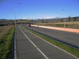
, which has been named the Farenkelly Road. It is a 4 km (2.5 mi) dual-carriageway that connects the town of Greystones
Greystones
Greystones is a coastal town and small seaside resort in County Wicklow, Ireland. It is located on Ireland’s east coast, south of Bray and south of Dublin , with a population in the region of 15,000....
with the N11 national primary road
National primary road
A national primary road is a road classification in the Republic of Ireland. National primary roads form the major routes between the major urban centres. There are over 2,700km of national primary roads. This category of road has the prefix "N" followed by one or two digits...
The road crosses the R761
R761 road
The R761 road is a regional road in County Wicklow in Ireland. From its junction with the M11 and R119 in Bray it takes a southerly route to its junction with the R750 in the village of Rathnew, on the outskirts of Wicklow, where it terminates.The road is long.En-route it passes through Bray,...
at a roundabout near Killincarrig
Killincarrig
Killincarrig is a suburban village between Greystones and Delgany in North County Wicklow. It lies at the crossroads of the R762 and the R761 roads. Like neighbouring Delgany it has been steadily built-up over the past 40 years and now forms part of the continuous urban area of Greystones....
and terminates at the R762
R762 road
The R762 road is a regional road in County Wicklow, Ireland, which connects the R761 at Greystones to the N11 national primary road.The route runs east via Rathdown Road, turns south through the town as Church Road before turning west as Mill Road...
in Charlesland, Greystones.
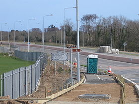
It was completed in 2004 but not connected to the N11 until June 2006, via a temporary "left-in, left-out" junction. The construction of a full grade interchange between the R774 and N11 was delayed when an illegal dump was unearthed at the original location for the junction.
Construction of the permanent fully grade-separated junction (J11 on the N11) started in October 2006 and was completed in 2008.
A distinctive feature of this road is the pink central barrier (see thumbnail); it may be the only coloured barrier in Ireland.