

R756 road
Encyclopedia
Regional road
A regional road in Ireland is a class of road not forming a major route , but nevertheless forming a link in the national route network. There are over 11,600 kilometres of regional roads. Regional roads are numbered with three digit route numbers, prefixed by "R" A regional road in Ireland is a...
in Ireland
Republic of Ireland
Ireland , described as the Republic of Ireland , is a sovereign state in Europe occupying approximately five-sixths of the island of the same name. Its capital is Dublin. Ireland, which had a population of 4.58 million in 2011, is a constitutional republic governed as a parliamentary democracy,...
running west-east from Dunlavin
Dunlavin
Dunlavin is a village in County Wicklow, Ireland, situated about thirty miles south west of Dublin. It is centred on the junction of the R412 and R756 regional roads...
to Laragh
Laragh, County Wicklow
Laragh is a small picturesque village in County Wicklow, Ireland. It lies at the junction of three roads through the Wicklow Mountains and is primarily known for its proximity to the monastic settlement of Glendalough...
. Its entire 32 km (19.9 mi) length is within County Wicklow
County Wicklow
County Wicklow is a county in Ireland. It is part of the Mid-East Region and is also located in the province of Leinster. It is named after the town of Wicklow, which derives from the Old Norse name Víkingalág or Wykynlo. Wicklow County Council is the local authority for the county...
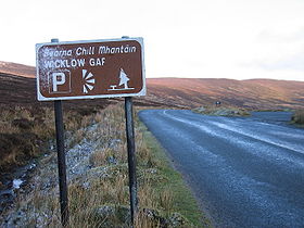
crossing east/west through the Wicklow Gap .
From Dunlavin it heads northeast, intersecting the N81
N81 road
The N81 road is a national secondary road in Ireland, connecting the gates of Trinity College, Dublin to Tullow, County Carlow, north to south. The N81 continues past Tullow for another 8 km to terminate at the village of Closh, County Carlow, where it intersects the N80. The N81 is long...
national secondary road
National secondary road
A national secondary road is a category of road in Ireland. These roads form an important part of the national route network, but are secondary to the main arterial routes which are classified as national primary roads. National secondary roads are designated with route numbers higher than those...
near the village of Hollywood
Hollywood, County Wicklow
Hollywood, historically known as Killinkeyvin , is a village in west County Wicklow, Ireland. It is situated on the Wicklow Gap road, near its junction with the N81 national secondary road...
. It then heads southeast, rising through the West Wicklow Mountains
Wicklow Mountains
The Wicklow Mountains form the largest continuous upland area in Ireland. They occupy the whole centre of County Wicklow and stretch outside its borders into Counties Carlow, Wexford and Dublin. Where the mountains extend into County Dublin, they are known locally as the Dublin Mountains...
to the Wicklow Gap, the highest point on the road at 470m, before descending through the Glandasan Valley. In this valley it passes through old mine-works to its junction with the R757 in the outskirts of Glendalough
Glendalough
Glendalough or Glendaloch is a glacial valley in County Wicklow, Ireland. It is renowned for its Early Medieval monastic settlement founded in the 6th century by St Kevin, a hermit priest, and partly destroyed in 1398 by English troops....
and continues for a further 2 km to Laragh, where it terminates at a junction with the R755
R755 road
The R755 road is a regional road in Ireland. It runs for its entire length in County Wicklow. From the village of Kilmacanogue on the N11 national primary road it goes north/south for to the town of Rathdrum.-Route:...
and the Military Road
R115 road
The R115 road is a regional road in counties Dublin and Wicklow in Ireland. It follows the Military Road for its entire length. The R115 is long; the full length of the Military Road is...
.
The 26 km (16.2 mi) section from Hollywood to Laragh is known as the Wicklow Gap Road ( and it is one of only two routes crossing the Wicklow Mountains from east to west, the other being the road through the Sally Gap
R115 road
The R115 road is a regional road in counties Dublin and Wicklow in Ireland. It follows the Military Road for its entire length. The R115 is long; the full length of the Military Road is...
in North Wicklow. The road through the Wicklow Gap is both an important regional route and a very popular tourist route as it travels through some spectacular scenery.
The Wicklow Gap, between Tonelagee Mountain
Tonelagee
Tonelagee is a mountain with a height of 817 m in County Wicklow, Republic of Ireland. It lies just north of the high point of the Wicklow Gap in the centre of the Wicklow Mountains. Tonelagee is the third highest of the Wicklow Mountains and the 33rd highest peak in Ireland...
and Camaderry Mountain
Camaderry
Camaderry is a mountain in the Wicklow Mountains, just south of the Wicklow Gap in County Wicklow, which runs over the gap between it and Tonelagee Mountain...
is where the entrance to Turlough Hill electricity 'storage' hydro-plant it situated. During periods of off-peak electricity demand, water is pumped up from Lough Nathanagan, a corrie lake at the foot of Turlough Hill to an artificial reservoir at the top; when electricity demand is high, the water falls back through turbines inside the mountain to produce hydro-electric power for the national grid.
From the summit of Wicklow Gap on a clear day, looking east, it is possible to look across the Irish Sea and see the mountains of Snowdonia in Wales.