

Queenstown, Tasmania
Encyclopedia
Queenstown is a town in the West Coast
region of the island of Tasmania
. It is located in a valley on western slopes of Mount Owen
on the West Coast Range.
It had a population of 5,119 people . At the 2006 census
, Queenstown had a population of 2,117.
industry. This mountainous area was first explored in 1862. It was long after that when alluvial gold was discovered at Mount Lyell
, prompting the formation of the Mount Lyell Gold Mining Company in 1881. In 1892, the mine began searching for copper. The final name of the Mount Lyell company was the Mount Lyell Mining and Railway Company
.
In the 1900s, Queenstown was the centre of the Mount Lyell mining district and had numerous smelting works, brick-works, and sawmills. The area at the time was finely wooded. The population in 1900 was 5051; the district, 10,451.
The town was the base of the Queenstown council up until amalgamation with other west coast councils in the 1990s. The town in its heyday had a collection of hotels, churches and schools that have all significantly reduced since the demise of the Mount Lyell company.
The town was the base of the Organisation for Tasmanian Development started in 1982.
There was a brief boom in prosperity in the 1980s, with the building of several nearby dams by the Hydro
. The Darwin and Crotty dams that comprise Lake Burbury (a popular fishing a recreation venue) were built during this period. These followed the cancellation of the Gordon-below-Franklin Dam in 1983 after strong campaigning by environmentalists in the 'No Dams' campaign.
Queenstown is now experiencing a revival, reflected in the popularity of its inaugural arts and heritage festival in 2010. The town is now home to a small but thriving arts community, and has inspired writers, painters, photographers and historians by both its unique beauty and history.
The newly restored Abt railway along with renewed mining and exploration activity in the region has also contributed to the town's rejuvenation in recent years.
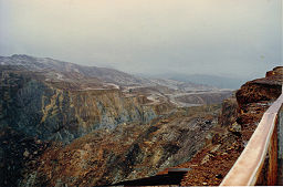 The mountains surrounding Queenstown have unusual pink and grey hues that come from the conglomerate rocks on the two most adjacent mountains - Mount Lyell and Mount Owen. The mountains surrounding Queenstown are often snowcapped through winter. Snow falls a few days out of the year.
 Owing to a combination of tree removal for use in the smelters, the smelter fumes (for about 40 years), and the heavy annual rainfall, the erosion of the shallow horizon topsoil back to the harder rock profile contributed to the stark state of the mountains for many decades.
Typical of the successions that occur in fire affected areas in Western Tasmania, the low shrubbery that has revegetated adjacent to hillside creeks is a very early stage of a long recovery for the ecology of the region.
Some concern by local residents in the 1980s, and since, that the low-level succession of plants might affect the stark 'moonscape' appearance of the southern parts of Mount Lyell, and northern Mount Owen. Although there are still large areas incapable of sustaining regrowth due to the acute slopes and lack of soil formation, the rate of vegetation recovery will render the mythologies arising from the appearance as only partial truths in time.
The Queen River
was for most of the history of the Mount Lyell company the recipient of mining effluent and the Queenstown sewage - which then continued into the King River and consequently the Macquarie Harbour
.
The Mount Lyell Remediation and Research and Demonstration Program
scheme has since removed the direct flowing mining waste and local waste from the rivers.
 Today, the town and district attracts significant numbers of tourists
, on either organised tours or the hire car 'circuit' around Tasmania. Some features continue to fascinate tourists, either the mountains, the slag heap or the gravel football ground. There are significant opportunities to catch glimpses of the town's past at the local museum, and simply by driving up Orr Street, the old main street now with closed pubs and the dominant Post Office tower.
The mining operation at the original Mount Lyell mine continues, with Copper Mines of Tasmania operating between 1995 and 1999 independently, after which it became part of an Indian company group - and its concentrates are shipped to India for processing.
Exploration continues within the West Coast region for further economic mineral deposits, and due to the complexity of the geology, there is always the possibility that new mines will open: the Henty Gold Mine
is a good example as it commenced operation in the 1990s.
Queenstown is the terminus of the West Coast Wilderness Railway
, which travels southwards alongside the Queen River
, and then along the northern slopes of the King River to the port of Strahan
in Macquarie Harbour
.
(Pictured Centre : Queenstown Oval
with a gravel surface constructed in 1880)
West Coast, Tasmania
The West Coast of Tasmania is the part of the state that is strongly associated with wilderness, mining and tourism, rough country and isolation...
region of the island of Tasmania
Tasmania
Tasmania is an Australian island and state. It is south of the continent, separated by Bass Strait. The state includes the island of Tasmania—the 26th largest island in the world—and the surrounding islands. The state has a population of 507,626 , of whom almost half reside in the greater Hobart...
. It is located in a valley on western slopes of Mount Owen
Mount Owen (Tasmania)
Mount Owen is the mountain directly east of the town of Queenstown in Tasmania, Australia.Like most of the mountains in the West Coast Range - it was named by Charles Gould after Richard Owen as the taller mountains were named after opponents or critics of Charles Darwin, the smaller after his...
on the West Coast Range.
It had a population of 5,119 people . At the 2006 census
Census in Australia
The Australian census is administered once every five years by the Australian Bureau of Statistics. The most recent census was conducted on 9 August 2011; the next will be conducted in 2016. Prior to the introduction of regular censuses in 1961, they had also been run in 1901, 1911, 1921, 1933,...
, Queenstown had a population of 2,117.
History
Queenstown's history has long been tied to the miningMining
Mining is the extraction of valuable minerals or other geological materials from the earth, from an ore body, vein or seam. The term also includes the removal of soil. Materials recovered by mining include base metals, precious metals, iron, uranium, coal, diamonds, limestone, oil shale, rock...
industry. This mountainous area was first explored in 1862. It was long after that when alluvial gold was discovered at Mount Lyell
Mount Lyell (Tasmania)
Mount Lyell is a mountain in the West Coast Range, Tasmania, named by Charles Gould in 1863 Charles Lyell was named during the nineteenth century controversy about the theory of evolution put forward by Charles Darwin, Lyell was a supporter of Darwin's....
, prompting the formation of the Mount Lyell Gold Mining Company in 1881. In 1892, the mine began searching for copper. The final name of the Mount Lyell company was the Mount Lyell Mining and Railway Company
Mount Lyell Mining and Railway Company
Mount Lyell Mining and Railway Company was a Tasmanian mining company formed on the 29 March 1893, most commonly referred to as Mount Lyell. Mount Lyell was the dominant copper mining company of the West Coast from 1893 to 1994, and was based in Queenstown, Tasmania.Following consolidation of...
.
In the 1900s, Queenstown was the centre of the Mount Lyell mining district and had numerous smelting works, brick-works, and sawmills. The area at the time was finely wooded. The population in 1900 was 5051; the district, 10,451.
The town was the base of the Queenstown council up until amalgamation with other west coast councils in the 1990s. The town in its heyday had a collection of hotels, churches and schools that have all significantly reduced since the demise of the Mount Lyell company.
The town was the base of the Organisation for Tasmanian Development started in 1982.
There was a brief boom in prosperity in the 1980s, with the building of several nearby dams by the Hydro
Hydro Tasmania
Hydro Tasmania, known for most of its history as The HEC, is the government owned enterprise which is the predominant electricity generator in the state of Tasmania, Australia...
. The Darwin and Crotty dams that comprise Lake Burbury (a popular fishing a recreation venue) were built during this period. These followed the cancellation of the Gordon-below-Franklin Dam in 1983 after strong campaigning by environmentalists in the 'No Dams' campaign.
Queenstown is now experiencing a revival, reflected in the popularity of its inaugural arts and heritage festival in 2010. The town is now home to a small but thriving arts community, and has inspired writers, painters, photographers and historians by both its unique beauty and history.
The newly restored Abt railway along with renewed mining and exploration activity in the region has also contributed to the town's rejuvenation in recent years.
Ecology
Typical of the successions that occur in fire affected areas in Western Tasmania, the low shrubbery that has revegetated adjacent to hillside creeks is a very early stage of a long recovery for the ecology of the region.
Some concern by local residents in the 1980s, and since, that the low-level succession of plants might affect the stark 'moonscape' appearance of the southern parts of Mount Lyell, and northern Mount Owen. Although there are still large areas incapable of sustaining regrowth due to the acute slopes and lack of soil formation, the rate of vegetation recovery will render the mythologies arising from the appearance as only partial truths in time.
The Queen River
Queen River
The Queen River is a river that flows through Queenstown Tasmania, to the west of the West Coast Range in particular Mount Lyell and Mount Owen....
was for most of the history of the Mount Lyell company the recipient of mining effluent and the Queenstown sewage - which then continued into the King River and consequently the Macquarie Harbour
Macquarie Harbour
Macquarie Harbour is a large, shallow, but navigable by shallow draft vessels inlet on the West Coast of Tasmania, Australia.-History:James Kelly wrote in his narrative "First Discovery of Port Davey and Macquarie Harbour" how he sailed from Hobart in a small open five-oared whaleboat to discover...
.
The Mount Lyell Remediation and Research and Demonstration Program
Mount Lyell Remediation and Research and Demonstration Program
The Mount Lyell Remediation and Research and Demonstration Program was a joint program between the Supervising Scientist Australia and the Department of Environment and Land Management, Tasmania to clean up the King River, Queen River and Macquarie Harbour following 100 years of mine waste and...
scheme has since removed the direct flowing mining waste and local waste from the rivers.
Current conditions
Tourism
Tourism is travel for recreational, leisure or business purposes. The World Tourism Organization defines tourists as people "traveling to and staying in places outside their usual environment for not more than one consecutive year for leisure, business and other purposes".Tourism has become a...
, on either organised tours or the hire car 'circuit' around Tasmania. Some features continue to fascinate tourists, either the mountains, the slag heap or the gravel football ground. There are significant opportunities to catch glimpses of the town's past at the local museum, and simply by driving up Orr Street, the old main street now with closed pubs and the dominant Post Office tower.
The mining operation at the original Mount Lyell mine continues, with Copper Mines of Tasmania operating between 1995 and 1999 independently, after which it became part of an Indian company group - and its concentrates are shipped to India for processing.
Exploration continues within the West Coast region for further economic mineral deposits, and due to the complexity of the geology, there is always the possibility that new mines will open: the Henty Gold Mine
Henty Gold Mine
The Henty Gold Mine is located at the head of the Henty River on the edge of the West Coast Range in Western Tasmania. It is approximately 30 km north of Queenstown. It is east of Zeehan and south of Tullah. It can be reached by the Hydro-built road that passes between the Henty River and...
is a good example as it commenced operation in the 1990s.
Queenstown is the terminus of the West Coast Wilderness Railway
West Coast Wilderness Railway
The West Coast Wilderness Railway, Tasmania is a reconstruction of the Mount Lyell Mining and Railway Company railway between Queenstown and Regatta Point...
, which travels southwards alongside the Queen River
Queen River
The Queen River is a river that flows through Queenstown Tasmania, to the west of the West Coast Range in particular Mount Lyell and Mount Owen....
, and then along the northern slopes of the King River to the port of Strahan
Strahan, Tasmania
-See also:* Convicts on the West Coast of Tasmania* Macquarie Harbour* Railways on the West Coast of Tasmania* West Coast Piners-Further reading:* *...
in Macquarie Harbour
Macquarie Harbour
Macquarie Harbour is a large, shallow, but navigable by shallow draft vessels inlet on the West Coast of Tasmania, Australia.-History:James Kelly wrote in his narrative "First Discovery of Port Davey and Macquarie Harbour" how he sailed from Hobart in a small open five-oared whaleboat to discover...
.
Further reading
- Davies P, Mitchell N and Barmuta L 1996 The impact of historical mining operations at Mount Lyell on the water quality and biological health of the King and Queen River catchments, western Tasmania. Mount Lyell Remediation Research and Demonstration Program. Supervising Scientist Report 118, Supervising Scientist, Canberra. ISBN 0-642-24317-4
- Gardiner, B. & L.A. In shadow of Lyell Devonport ,Tas.: B. & L.A. Gardiner, 1983. ISBN 0959242422 :
- 2003 edition - Queenstown: Municipality of Queenstown.
- 1949 edition - Hobart: Davies Brothers.
- 1924 edition - Queenstown: Mount Lyell Tourist Association.
External links
- Images of Mount Lyell smelters, from State Library of Tasmania * images collection
- http://www.heritageaustralia.com.au/search.php?state=TAS®ion=119&view=107#a - useful details of the hotels of the main street.
- http://www.parks.tas.gov.au/wha/wherein/detail.html - context of position with World Heritage Area
- http://www.queenstowntasmania.com/ Locally Produced Information web site
- http://www.abc.net.au/tv/collectors/txt/s1978058.htm - Janine Manssons ABC Collectors Review
(Pictured Centre : Queenstown Oval
Queenstown Oval, Tasmania
Queenstown Oval, built in 1880, is an infamous gravel playing surface in Queenstown located on the west coast of Tasmania. The ground has a main concrete grandstand and a total capacity of 5,000....
with a gravel surface constructed in 1880)