

Queen's Quay (Toronto)
Encyclopedia
Queen's Quay is a prominent street in the Harbourfront
neighbourhood of Toronto
, Ontario
, Canada
. The street was originally commercial in nature due to the many working piers along the waterfront. It has been extensively rebuilt in the past two decades with high-rise condominium, retail and institutional development.
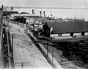
and Lake Shore Boulevard as the most southerly east-west corridor in the city when it was created on reclaimed land in the inner harbour
. Sometime after 1919 to the early 1920s the inner harbour was filled in and new slips were created.
 Queens Quay continues to go through a significant transformation. Originally, it served as an access road for the various ports and slips in the inner harbour. The street between Yonge Street
and Parliament Street was home to storage buildings devoted to trade on the Saint Lawrence Seaway
, major industries such as the Redpath Sugar Refinery and Victory Mills
, as well as small commercial enterprises. However, the mainly industrial uses along Queens Quay were slowly replaced by commercial and residential uses, mainly high-rise condominiums. Between 1975 and 1979, a cluster of large, concrete towers were erected at the foot of Bay Street, south of Queens Quay; these included the Westin Harbour Castle and Harbour Square. In 1990, the 40-storey York Quay towers were built and remain the tallest buildings on Queens Quay.. The scale and density of these and subsequent high-rise development along Queens Quay were criticized for blocking the lake and failing to provide a welcoming realm for visitors. In 1999, the Toronto Transit Commission
opened a dedicated streetcar right-of-way in the median from Bay Street
to Bathurst Street.
In 2001, the city planners set out to improve Queens Quay by reclaiming public space for pedestrians and cyclists. This resulted in the Waterfront Toronto Central Waterfront Public Realm International Design Competition, which was completed in 2006. In August 2006, the city closed the two eastbound lanes, replacing them with bike lanes and additional pedestrian space. The experiment resulted in an improved public realm and more visitors to the overall waterfront area.
In 2009, Waterfront Toronto announced its plans to turn Queens Quay into a grand lakefront boulevard by placing streetcar lanes in the centre, traffic only on the north side and a pedestrian focused space on the south side. The plan will restrict Queen’s Quay to two traffic lanes, on the north side of the streetcar tracks, similar to the design of the 2006 experiment. Additionally, the plan calls for the beautification and extension of the Harbourfront streetcar line along Queen’s Quay East between Yonge and Cherry Street. The transit right-of-way will be grass-covered.
and 510 Spadina both terminate at Union Station
and run along Queen's Quay from Bay Street, westward. At Spadina Avenue
, the 510 heads north to Spadina Station
, and the 509 continues west, bound for the Exhibition Loop
.
Plans to add a streetcar line on the eastern end on Queen's Quay are currently (as of February 2007) the subject of a class environmental assessment. Various bus routes currently serve portions of the eastern portion of Queen's Quay: the 6 Bay operates from Bay Street to Jarvis Street, the 75 Sherbourne operates from Jarvis Street to Sherbourne Street, and the 97 Yonge and 320 Yonge Blue Night
buses operate from Bay Street to Yonge Street
.
Harbourfront
Harbourfront is a neighbourhood on the northern shore of Lake Ontario within the downtown core of the city of Toronto, Canada. Part of the Toronto Waterfront, Harbourfront extends west from Yonge Street to Bathurst Street along Queen's Quay. East of Yonge to Parliament St...
neighbourhood of Toronto
Toronto
Toronto is the provincial capital of Ontario and the largest city in Canada. It is located in Southern Ontario on the northwestern shore of Lake Ontario. A relatively modern city, Toronto's history dates back to the late-18th century, when its land was first purchased by the British monarchy from...
, Ontario
Ontario
Ontario is a province of Canada, located in east-central Canada. It is Canada's most populous province and second largest in total area. It is home to the nation's most populous city, Toronto, and the nation's capital, Ottawa....
, Canada
Canada
Canada is a North American country consisting of ten provinces and three territories. Located in the northern part of the continent, it extends from the Atlantic Ocean in the east to the Pacific Ocean in the west, and northward into the Arctic Ocean...
. The street was originally commercial in nature due to the many working piers along the waterfront. It has been extensively rebuilt in the past two decades with high-rise condominium, retail and institutional development.
History
The road replaced both Front StreetFront Street (Toronto)
Front Street is an east-west road in downtown Toronto, Ontario, Canada. The street marks the rough outline of the shoreline of Lake Ontario as it existed during the original English settlement of York, then called Palace Street...
and Lake Shore Boulevard as the most southerly east-west corridor in the city when it was created on reclaimed land in the inner harbour
Toronto Harbour
Toronto Harbour or Toronto Bay is a bay on the north shore of Lake Ontario, in Toronto, Ontario, Canada. It is a natural harbour, protected from Lake Ontario waves by the Toronto Islands. It is a commercial port on the Great Lakes as well as a recreational harbour...
. Sometime after 1919 to the early 1920s the inner harbour was filled in and new slips were created.
Yonge Street
Yonge Street is a major arterial route connecting the shores of Lake Ontario in Toronto to Lake Simcoe, a gateway to the Upper Great Lakes. It was formerly listed in the Guinness Book of Records as the longest street in the world at , and the construction of Yonge Street is designated an "Event of...
and Parliament Street was home to storage buildings devoted to trade on the Saint Lawrence Seaway
Saint Lawrence Seaway
The Saint Lawrence Seaway , , is the common name for a system of locks, canals and channels that permits ocean-going vessels to travel from the Atlantic Ocean to the North American Great Lakes, as far as Lake Superior. Legally it extends from Montreal to Lake Erie, including the Welland Canal...
, major industries such as the Redpath Sugar Refinery and Victory Mills
Victory Soya Mills Silos
Victory Soya Mills Silos in the east end of Toronto's harbourfront is one of the two remaining silos from Toronto's industrial port era. They were built by E.P. Taylor Victory Mills company in 1943 to house the soy beans used by a large plant that reprocessed the soy for a variety of purposes.The...
, as well as small commercial enterprises. However, the mainly industrial uses along Queens Quay were slowly replaced by commercial and residential uses, mainly high-rise condominiums. Between 1975 and 1979, a cluster of large, concrete towers were erected at the foot of Bay Street, south of Queens Quay; these included the Westin Harbour Castle and Harbour Square. In 1990, the 40-storey York Quay towers were built and remain the tallest buildings on Queens Quay.. The scale and density of these and subsequent high-rise development along Queens Quay were criticized for blocking the lake and failing to provide a welcoming realm for visitors. In 1999, the Toronto Transit Commission
Toronto Transit Commission
-Island Ferry:The ferry service to the Toronto Islands was operated by the TTC from 1927 until 1962, when it was transferred to the Metro Parks and Culture department. Since 1998, the ferry service is run by Toronto Parks and Recreation.-Gray Coach:...
opened a dedicated streetcar right-of-way in the median from Bay Street
Bay Street
Bay Street, originally known as Bear Street, is a major thoroughfare in Downtown Toronto. It is the centre of Toronto's Financial District and is often used by metonymy to refer to Canada's financial industry since succeeding Montreal's St. James Street in that role in the 1970s...
to Bathurst Street.
In 2001, the city planners set out to improve Queens Quay by reclaiming public space for pedestrians and cyclists. This resulted in the Waterfront Toronto Central Waterfront Public Realm International Design Competition, which was completed in 2006. In August 2006, the city closed the two eastbound lanes, replacing them with bike lanes and additional pedestrian space. The experiment resulted in an improved public realm and more visitors to the overall waterfront area.
In 2009, Waterfront Toronto announced its plans to turn Queens Quay into a grand lakefront boulevard by placing streetcar lanes in the centre, traffic only on the north side and a pedestrian focused space on the south side. The plan will restrict Queen’s Quay to two traffic lanes, on the north side of the streetcar tracks, similar to the design of the 2006 experiment. Additionally, the plan calls for the beautification and extension of the Harbourfront streetcar line along Queen’s Quay East between Yonge and Cherry Street. The transit right-of-way will be grass-covered.
Transportation
Queen's Quay is served by two streetcar lines, operating on a dedicated right-of-way. The 509 Harbourfront509 Harbourfront
509 Harbourfront is a streetcar route in Toronto, Ontario, Canada, operated by the Toronto Transit Commission.-History:The Harbourfront LRT, originally designated 604 Harbourfront, began service in 1990...
and 510 Spadina both terminate at Union Station
Union Station (Toronto)
Union Station is the major inter-city rail station and a major commuter rail hub in Toronto, located on Front Street West and occupying the south side of the block bounded by Bay Street and York Street in the central business district. The station building is owned by the City of Toronto, while the...
and run along Queen's Quay from Bay Street, westward. At Spadina Avenue
Spadina Avenue
Spadina Avenue is one of the most prominent streets in Toronto, Ontario, Canada. Running through the western section of downtown, the road has a very different character in different neighbourhoods....
, the 510 heads north to Spadina Station
Spadina (TTC)
Spadina is a station on the Yonge-University-Spadina and Bloor-Danforth lines of the subway system in Toronto, Ontario, Canada. Out of all the interchange stations, this one is the least-used with approximately 47,570 people using both platforms each day...
, and the 509 continues west, bound for the Exhibition Loop
Exhibition Loop (TTC)
Exhibition Loop is the terminus for the 511 Bathurst and 509 Harbourfront streetcar routes and serves:* CNE at the Exhibition Place* Ricoh Coliseum* Exhibition GO Station* BMO Field-History:...
.
Plans to add a streetcar line on the eastern end on Queen's Quay are currently (as of February 2007) the subject of a class environmental assessment. Various bus routes currently serve portions of the eastern portion of Queen's Quay: the 6 Bay operates from Bay Street to Jarvis Street, the 75 Sherbourne operates from Jarvis Street to Sherbourne Street, and the 97 Yonge and 320 Yonge Blue Night
Blue Night Network
The Blue Night Network is the overnight public transit service operated by the Toronto Transit Commission in Toronto, Ontario, Canada. The network consists of a basic grid of 22 bus and 2 streetcar routes, distributed so that almost all of the city is within 2 km of at least one...
buses operate from Bay Street to Yonge Street
Yonge Street
Yonge Street is a major arterial route connecting the shores of Lake Ontario in Toronto to Lake Simcoe, a gateway to the Upper Great Lakes. It was formerly listed in the Guinness Book of Records as the longest street in the world at , and the construction of Yonge Street is designated an "Event of...
.
Landmarks
| Landmark | Cross street | Notes | Image |
|---|---|---|---|
| HMCS York HMCS York HMCS York is a Canadian Forces Naval Reserve Division located in Toronto, Ontario. Before the move to its current location on Lake Shore Boulevard West, it had been situated on the grounds of the Canadian National Exhibition... |
Bathurst | Canadian Forces Naval Reserve Division | |
| Tip Top Tailors Building | Bathurst | industrial building converted to condominium lofts | |
| Little Norway Park Little Norway Park Little Norway Park is a small park located in downtown Toronto, Canada at the southwest corner of Bathurst Street and Queen's Quay West.A totem pole is located near Queen's Quay West on the park property.... |
Bathurst | ||
| Canada Malting Silos Canada Malting Silos Canada Malting Silos is one of two remaining silos in Toronto's Harbourfront in Ontario, Canada. Located at the foot of Bathurst Street at Bathurst Quay , the silos were built in 1928 to store malt for the Canada Malting Company. It was an important work of industrial architecture, grain elevators... |
Bathurst | Abandoned storage silos | 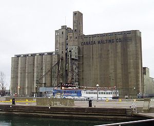 |
| Walter Carsen Centre Walter Carsen Centre Walter Carsen Centre in Toronto, Canada is a building at 470 Queen's Quay West on the Toronto water front. The lower levels house the headquarters of the National Ballet of Canada and the ballet's rehearsal space. The facility has 8,825 square metres of space, more than the Four Seasons Centre... |
Spadina | headquarters of the National Ballet of Canada | 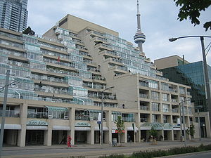 |
| Empire Sandy Empire Sandy The Empire Sandy is a tall ship providing chartered tours for the public from Toronto, Canada. She was built as a Englishman/Larch Deep Sea class tugboat for war service by the British Government in 1943... |
Spadina | 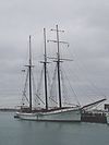 |
|
| HTO Park HTO Park HTO is an urban beach in Toronto, Canada, that opened in 2007. It west of Harbourfront Centre, on Lake Ontario.-History:The park is built on quays that was once used by ships berthing in Toronto's Inner Harbour.The park consists of two sections:... |
Spadina |  |
|
| Harbourfront Centre Harbourfront Centre Harbourfront Centre is a key cultural organization on Toronto, Ontario's waterfront, situated at 235 Queen's Quay West. Established as a crown corporation in 1972 by the federal government to create a waterfront park, it became a non-profit organization in 1991. Funding comes from corporate... |
Lower Simcoe | a cultural centre built by the federal government as part of the Harbourfront Park development | |
| Queen's Quay Terminal Queen's Quay Terminal Queen's Quay Terminal was a cold storage warehouse facility, the Toronto Terminal Warehouse, built in 1926 by Moores & Dunford and converted to a condo/mall complex in 1983... |
York | a cold storage warehouse facility turned into condos | |
| Queens Quay Station | Bay | Underground LRT station | |
| Westin Harbour Castle Hotel Westin Harbour Castle Hotel The Westin Harbour Castle Hotel is a large, modern hotel located on 1 Harbour Square, next to the waterfront of Toronto, Ontario, Canada. It is part of the Westin Hotels chain.... |
Bay |  |
|
| World Trade Centre | Yonge | 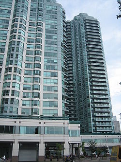 |
|
| Captain John's Harbour Boat Restaurant Captain John's Harbour Boat Restaurant Captain John's Harbour Boat Restaurant is a noted restaurant and banquet hall in Toronto, Ontario, Canada. It is located in the MS Jadran a former Adriatic passenger ship now permanently docked at Yonge Street and Queen's Quay on Toronto's waterfront... |
Yonge | Restaurant on a permanently docked boat | |
| One Yonge Street One Yonge Street One Yonge Street, built in 1970, is a 25 storey building, and is home to the Toronto Star newspaper. It is 100 metres tall, and is built in the International style. It was built as a replacement to the Old Toronto Star Building, which was located at 80 King Street West... |
Yonge | Toronto Star headquarters | 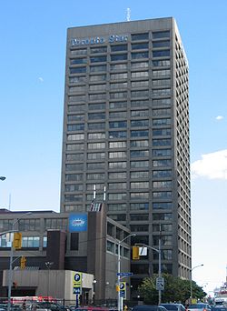 |
| Redpath Sugar Refinery | Jarvis | Last active industrial site along the quay | 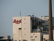 |
| The Guvernment The Guvernment The Guvernment is the name of a nightclub complex in Toronto, Ontario, Canada. Opened in 1996, it was incarnated from the former RPM nightclub, which closed its doors after several years at the same location.Saturdays The Guvernment is the name of a nightclub complex in Toronto, Ontario, Canada.... |
Jarvis | night club | 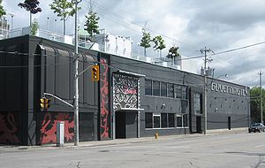 |
| Sugar Beach Sugar Beach Sugar Beach is an urban beach park in Toronto, Canada, that opened in 2010. It is located across from Redpath Sugar Refinery in Toronto's eastern East Bayfront. Like HTO Park, the beach has no direct access to the Lake Ontario and is a landlocked beach.... |
Jarvis | ||
| Corus Quay Corus Quay Corus Quay, originally named First Waterfront Place, is an 8 storey commercial office tower located on a waterfront site in Toronto, Ontario, Canada. The $160 million building is the first major development planned for the East Bayfront Precinct, and completed construction at the foot of Jarvis... |
Jarvis | Home of Corus Entertainment and first major development in the East Bayfront District | |
| Victory Soya Mills Silos Victory Soya Mills Silos Victory Soya Mills Silos in the east end of Toronto's harbourfront is one of the two remaining silos from Toronto's industrial port era. They were built by E.P. Taylor Victory Mills company in 1943 to house the soy beans used by a large plant that reprocessed the soy for a variety of purposes.The... |
Parliament | Abandoned industrial silos | 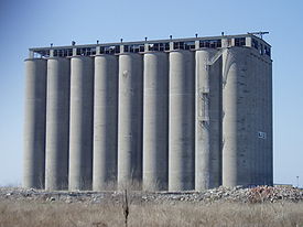 |
Quays/Slips along Queen's Quay
Listed from west to east- Bathurst Quay (Éireann Quay) - see Ireland ParkIreland ParkIreland Park is located in Toronto on the shores of Lake Ontario on Éireann Quay at the foot of Bathurst Street. Officially opened in the summer of 2007, Ireland Park commemorates the tens of thousands who fled Ireland during the Great Famine...
and Canada Malting SilosCanada Malting SilosCanada Malting Silos is one of two remaining silos in Toronto's Harbourfront in Ontario, Canada. Located at the foot of Bathurst Street at Bathurst Quay , the silos were built in 1928 to store malt for the Canada Malting Company. It was an important work of industrial architecture, grain elevators... - SpadinaSpadina AvenueSpadina Avenue is one of the most prominent streets in Toronto, Ontario, Canada. Running through the western section of downtown, the road has a very different character in different neighbourhoods....
Quay - Peter Street Slip
- Maple Leaf Quays
- Rees Street Slip
- John Street Quay
- Simcoe Street Slip
- York Quay
- York Street Slip
- Harbour Square
- Yonge StreetYonge StreetYonge Street is a major arterial route connecting the shores of Lake Ontario in Toronto to Lake Simcoe, a gateway to the Upper Great Lakes. It was formerly listed in the Guinness Book of Records as the longest street in the world at , and the construction of Yonge Street is designated an "Event of...
Slip - Pier 27
- Jarvis StreetJarvis StreetJarvis Street is a north-south thoroughfare in downtown Toronto, Ontario, Canada, passing through some of the oldest developed areas in the city. Its alignment extends from Bloor Street in the north to Queens Quay East in the south. South of Front Street, it continues as Lower Jarvis Street...
Slip - now Corus QuayCorus QuayCorus Quay, originally named First Waterfront Place, is an 8 storey commercial office tower located on a waterfront site in Toronto, Ontario, Canada. The $160 million building is the first major development planned for the East Bayfront Precinct, and completed construction at the foot of Jarvis... - Redpath Slip
- Parliament Street Slip