
Quaking Houses
Encyclopedia
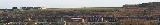
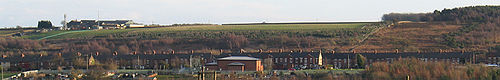
Quaking Houses is a small village near to the town of Stanley
in County Durham
, in England
. It may have been originally settled by Quakers
, but during the Industrial Revolution
it developed into a mining
village with traditional terraced houses. The Quaker origin is supported by the 1873 name for a mine with two shafts at the village called Quaker House Pit. However, an alternative origin is suggested by the following; the 1865 OS Map shows a farm called Quaking House to the north at Anfield Plain and a colliery railway line ran past this farm branching to the village mine. This colliery railway line was called the Quaking House Branch Line. An amusing colloquial name for the village was "nanny goat island" perhaps reflecting the livestock kept in the extensive allotments and grazing area around the village.
Accessible by road only from the main South Moor
Road, the village is dominated by one large road, with large strips of terraced housing on either side, both facing outwards. The large road is divided into several different street names: Third Street and Fourth Street, with Woodside Terrace and Fellside Terrace located at the west end. A large turning circle enables large vehicles, particularly buses, to change direction.
A shorter road parallel to the large road once had two streets, First Street and Second Street. The Community Hall which opened in 1997 stands where First street was once situated and Second Street still remains. The original housing stock was tied property which passed to the National Coal Board
following nationalisation of the coal
industry. The properties in Fellside and Woodside Terrace were larger than the other properties and were originally occupied by people with "middle management" occupations in the mining industry. As the coal mining industry declined these properties were progressively sold off into private ownership. In the 1960s, Quaking Houses was declared a Category D village under the County Durham development plan. Category D villages were to be left to die with the mining industry and planning consents for further development were to be refused. The Category D policy waned over time and new housing development has taken place.
At one time at the bottom of Fourth Street stood a walled reservoir and at the top of the village on the fell in the woodland was a dam, both of which had been required for the mines in the area. The William Pit, colloquially known as the Billy Pit, and which, prior to nationalisation, was owned by the South Moor and Holmside Colliery Company [SM&HCC] stood near the reservoir. SM&HCC also operated a drift mine in the Stanley Burn valley to the north of Woodside Terrace.
Quaking Houses fell, which is an outstanding example of lowland heath, sweeps down towards Fourth Steet and Fellside Terrace.
The village is often colloquially referred to as 'Quakies'. It is adjacent to the larger village of South Moor
.
Stanley, County Durham
Stanley is a former colliery town and civil parish in County Durham, England. Centred on a hilltop between Chester-le-Street and Consett, the town lies south west of Gateshead....
in County Durham
County Durham
County Durham is a ceremonial county and unitary district in north east England. The county town is Durham. The largest settlement in the ceremonial county is the town of Darlington...
, in England
England
England is a country that is part of the United Kingdom. It shares land borders with Scotland to the north and Wales to the west; the Irish Sea is to the north west, the Celtic Sea to the south west, with the North Sea to the east and the English Channel to the south separating it from continental...
. It may have been originally settled by Quakers
Religious Society of Friends
The Religious Society of Friends, or Friends Church, is a Christian movement which stresses the doctrine of the priesthood of all believers. Members are known as Friends, or popularly as Quakers. It is made of independent organisations, which have split from one another due to doctrinal differences...
, but during the Industrial Revolution
Industrial Revolution
The Industrial Revolution was a period from the 18th to the 19th century where major changes in agriculture, manufacturing, mining, transportation, and technology had a profound effect on the social, economic and cultural conditions of the times...
it developed into a mining
Mining
Mining is the extraction of valuable minerals or other geological materials from the earth, from an ore body, vein or seam. The term also includes the removal of soil. Materials recovered by mining include base metals, precious metals, iron, uranium, coal, diamonds, limestone, oil shale, rock...
village with traditional terraced houses. The Quaker origin is supported by the 1873 name for a mine with two shafts at the village called Quaker House Pit. However, an alternative origin is suggested by the following; the 1865 OS Map shows a farm called Quaking House to the north at Anfield Plain and a colliery railway line ran past this farm branching to the village mine. This colliery railway line was called the Quaking House Branch Line. An amusing colloquial name for the village was "nanny goat island" perhaps reflecting the livestock kept in the extensive allotments and grazing area around the village.
Accessible by road only from the main South Moor
South Moor
South Moor is a village in County Durham, in England. It is located to the south-west of Stanley on the northern slope of the Craghead valley. It is a well-developed village, yet still semi rural, containing a main street of around twelve shops which survive despite their proximity to the front...
Road, the village is dominated by one large road, with large strips of terraced housing on either side, both facing outwards. The large road is divided into several different street names: Third Street and Fourth Street, with Woodside Terrace and Fellside Terrace located at the west end. A large turning circle enables large vehicles, particularly buses, to change direction.
A shorter road parallel to the large road once had two streets, First Street and Second Street. The Community Hall which opened in 1997 stands where First street was once situated and Second Street still remains. The original housing stock was tied property which passed to the National Coal Board
National Coal Board
The National Coal Board was the statutory corporation created to run the nationalised coal mining industry in the United Kingdom. Set up under the Coal Industry Nationalisation Act 1946, it took over the mines on "vesting day", 1 January 1947...
following nationalisation of the coal
Coal
Coal is a combustible black or brownish-black sedimentary rock usually occurring in rock strata in layers or veins called coal beds or coal seams. The harder forms, such as anthracite coal, can be regarded as metamorphic rock because of later exposure to elevated temperature and pressure...
industry. The properties in Fellside and Woodside Terrace were larger than the other properties and were originally occupied by people with "middle management" occupations in the mining industry. As the coal mining industry declined these properties were progressively sold off into private ownership. In the 1960s, Quaking Houses was declared a Category D village under the County Durham development plan. Category D villages were to be left to die with the mining industry and planning consents for further development were to be refused. The Category D policy waned over time and new housing development has taken place.
At one time at the bottom of Fourth Street stood a walled reservoir and at the top of the village on the fell in the woodland was a dam, both of which had been required for the mines in the area. The William Pit, colloquially known as the Billy Pit, and which, prior to nationalisation, was owned by the South Moor and Holmside Colliery Company [SM&HCC] stood near the reservoir. SM&HCC also operated a drift mine in the Stanley Burn valley to the north of Woodside Terrace.
Quaking Houses fell, which is an outstanding example of lowland heath, sweeps down towards Fourth Steet and Fellside Terrace.
The village is often colloquially referred to as 'Quakies'. It is adjacent to the larger village of South Moor
South Moor
South Moor is a village in County Durham, in England. It is located to the south-west of Stanley on the northern slope of the Craghead valley. It is a well-developed village, yet still semi rural, containing a main street of around twelve shops which survive despite their proximity to the front...
.