

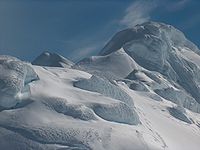
Presian Ridge
Encyclopedia
Friesland Ridge
Friesland Ridge is a ridge on Livingston Island in the South Shetlands, part of the Tangra Mountains. The summit, Mount Friesland, which rises to , is the northwesternmost of the ridge’s six main peaks...
, Tangra Mountains
Tangra Mountains
Tangra Mountains form the principal mountain range of Livingston Island in the South Shetland Islands, Antarctica...
, Livingston Island in the South Shetland Islands
South Shetland Islands
The South Shetland Islands are a group of Antarctic islands, lying about north of the Antarctic Peninsula, with a total area of . By the Antarctic Treaty of 1959, the Islands' sovereignty is neither recognized nor disputed by the signatories and they are free for use by any signatory for...
, Antarctica. Situated between the island's summit Mount Friesland
Mount Friesland
Mount Friesland is the summit of Tangra Mountains on Livingston Island, in the South Shetland Islands, Antarctica. The peak is rising to 1700 m sharp, and is heavily glaciated and crevassed. Situated 12.5 km northeast of Barnard Point, 9.7 km east-southeast of St...
(1700 m) to the west and Catalunyan Saddle
Catalunyan Saddle
Catalunyan Saddle is a saddle of 1260 m height in the Friesland Ridge of the Tangra Mountains on Livingston Island, in the South Shetland Islands. The saddle is bounded by Lyaskovets Peak to the east and by Presian Ridge to the west. The saddle was named in honour of the Catalans Francesc Sàbat...
to the east. Surmounting Wörner Gap
Wörner Gap
Wörner Gap is a flat saddle extending 3 km in the south-north direction between Friesland Ridge and Bowles Ridge in eastern Livingston Island in the South Shetland Islands, Antarctica. Its elevation decreases from 585 m in the south to 541 m in the middle, and 525 m in the north...
, Camp Academia
Camp Academia
Camp Academia is a geographical locality in eastern Livingston Island, South Shetland Islands, Antarctica, named for the Bulgarian Academy of Sciences in appreciation of Academy’s contribution to the Antarctic exploration...
locality and upper Huron Glacier
Huron Glacier
Huron Glacier is a 7.7 km long and 3.5 km wide glacial flow on Livingston Island in the South Shetland Islands, Antarctica. The glacier is bounded by Bowles Ridge to the north, Wörner Gap to the west and Tangra Mountains to the south, receiving ice influx from several tributary glaciers...
to the north, and Macy Glacier
Macy Glacier
Macy Glacier is a 6 km long and 2.3 km crescent-shaped glacier on the southern slopes of Tangra Mountains, Livingston Island in the South Shetland Islands, Antarctica...
to the south.
First ascent by the Catalans Francesc Sàbat and Jorge Enrique from Juan Carlos I Base
Juan Carlos I Base
Juan Carlos I Antarctic Base, named after the king of Spain, Juan Carlos I, is a seasonal scientific station operated by Spain, opened in January 1988...
on 30 December 1991.
The ridge is named after Khan Presian of Bulgaria
Bulgaria
Bulgaria , officially the Republic of Bulgaria , is a parliamentary democracy within a unitary constitutional republic in Southeast Europe. The country borders Romania to the north, Serbia and Macedonia to the west, Greece and Turkey to the south, as well as the Black Sea to the east...
, 836-852 AD, who brought the Bulgaria
Bulgaria
Bulgaria , officially the Republic of Bulgaria , is a parliamentary democracy within a unitary constitutional republic in Southeast Europe. The country borders Romania to the north, Serbia and Macedonia to the west, Greece and Turkey to the south, as well as the Black Sea to the east...
n lands in Macedonia
Macedonia (region)
Macedonia is a geographical and historical region of the Balkan peninsula in southeastern Europe. Its boundaries have changed considerably over time, but nowadays the region is considered to include parts of five Balkan countries: Greece, the Republic of Macedonia, Bulgaria, Albania, Serbia, as...
together with those in Thrace
Thrace
Thrace is a historical and geographic area in southeast Europe. As a geographical concept, Thrace designates a region bounded by the Balkan Mountains on the north, Rhodope Mountains and the Aegean Sea on the south, and by the Black Sea and the Sea of Marmara on the east...
, Moesia
Moesia
Moesia was an ancient region and later Roman province situated in the Balkans, along the south bank of the Danube River. It included territories of modern-day Southern Serbia , Northern Republic of Macedonia, Northern Bulgaria, Romanian Dobrudja, Southern Moldova, and Budjak .-History:In ancient...
, Panonia, Dacia
Dacia
In ancient geography, especially in Roman sources, Dacia was the land inhabited by the Dacians or Getae as they were known by the Greeks—the branch of the Thracians north of the Haemus range...
and Scythia
Scythia
In antiquity, Scythian or Scyths were terms used by the Greeks to refer to certain Iranian groups of horse-riding nomadic pastoralists who dwelt on the Pontic-Caspian steppe...
.
Location
The summit point of the ridge is located at 62°40′03.8"S 60°09′55.3"W, which is 1.11 km east of Mount Friesland, 4.14 km southeast of Pliska Peak, 3.54 km south by west of Kuzman KnollKuzman Knoll
Kuzman Knoll is a solitary ice-covered knoll rising to 620 m in eastern Livingston Island in the South Shetland Islands, Antarctica. The knoll forms a conspicuous landmark in Wörner Gap area, overlooking Huron Glacier and upper Perunika Glacier...
, 1.24 km west-southwest of Lyaskovets Peak
Lyaskovets Peak
Lyaskovets Peak is the easternmost peak of Friesland Ridge in the Tangra Mountains, eastern Livingston Island and has an elevation 1,473 m...
and 4.08 km north-northwest of Peshev Peak (Bulgarian topographic survey Tangra 2004/05
Tangra 2004/05
The Tangra 2004/05 Expedition was commissioned by the Antarctic Place-names Commission at the Ministry of Foreign Affairs of Bulgaria, managed by the Manfred Wörner Foundation, and supported by the Bulgarian Antarctic Institute, the Institute of Mathematics and Informatics at the Bulgarian Academy...
, and mapping in 2005 and 2009).
Maps
- L.L. Ivanov et al. Antarctica: Livingston Island and Greenwich Island, South Shetland Islands. Scale 1:100000 topographic map. Sofia: Antarctic Place-names Commission of Bulgaria, 2005.
- L.L. Ivanov. Antarctica: Livingston Island and Greenwich, Robert, Snow and Smith Islands. Scale 1:120000 topographic map. Troyan: Manfred Wörner Foundation, 2009. ISBN 978-954-92032-6-4