Pre-Pyrenees
Encyclopedia

Foothills
Foothills are geographically defined as gradual increases in elevation at the base of a mountain range. They are a transition zone between plains and low relief hills to the adjacent topographically high mountains.-Examples:...
of the Pyrenees
Pyrenees
The Pyrenees is a range of mountains in southwest Europe that forms a natural border between France and Spain...
.
Description
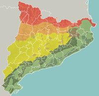
As a mountainous system the Pre-Pyrenees are part of the Pyrenees. They run parallel to the main mountain range in a west to east direction. At the eastern end lies the area known as the Sub-PyreneesSub-Pyrenees
The Sub-Pyrenees are a chain of mountains in Spain. They form a section of the southern foothills of the Pyrenees. They are located at the eastern end of the Pre-Pyrenees, west of the Catalan Transversal Range, between the lower Ripollès and an area of the high Garrotxa.The Sub-Pyrenees consist of...
.
On the French side the Pyrenees's slopes descend rather abruptly, thus on the northern side, the Pre-Pyrenees are confined to the Corbières Range
Corbières (mountains)
The Corbières is a mountain range in the Pre-Pyrenees.-Geography:The Corbières are a mountain region in the Languedoc-Roussillon in southwestern France, located in the departements of Aude and Pyrénées-Orientales....
, towards the eastern end of the mountain system. The Massif de Plantaurel further west deserves mention as well, although not as clearly a foothill.
On the Iberian side, however, the picture is very different: a large and complex system of foothill ranges stretches from Navarre
Navarre
Navarre , officially the Chartered Community of Navarre is an autonomous community in northern Spain, bordering the Basque Country, La Rioja, and Aragon in Spain and Aquitaine in France...
, across northern Aragon
Aragon
Aragon is a modern autonomous community in Spain, coextensive with the medieval Kingdom of Aragon. Located in northeastern Spain, the Aragonese autonomous community comprises three provinces : Huesca, Zaragoza, and Teruel. Its capital is Zaragoza...
, reaching the Mediterranean coast on the Catalan
Catalonia
Catalonia is an autonomous community in northeastern Spain, with the official status of a "nationality" of Spain. Catalonia comprises four provinces: Barcelona, Girona, Lleida, and Tarragona. Its capital and largest city is Barcelona. Catalonia covers an area of 32,114 km² and has an...
end of the Pyrenees.
Main ranges
Although the highest peaks in the Pre-Pyrenees are not as high as those in the PyreneesPyrenees
The Pyrenees is a range of mountains in southwest Europe that forms a natural border between France and Spain...
proper, some summits reach 2.500 m. The main ranges include:
Northern Slope:
- Corberes
- Massif de Plantaurel
Southern Slope:
- Mare de Déu del Mont
- Serra del MontsecSerra del MontsecThe Serra del Montsec is a mountain system of the Pre-Pyrenees.-Description:The Serra del Montsec consists of a series of calcareous mountain ranges. Runs from east to west, it is about 40 km long and 186.96 square kilometres in area...
- Serra del CadíSerra del CadíThe Serra del Cadí is a mountain range running north of Catalonia, Spain, part of the Pre-Pyrenees. Its highest peak is the Vulturó, with an altitude of 2,648 metres....
- Serra de Boumort
- Serra de Moixeró
- El Port del Comte
- Serra de Montgrony
- Sierra de GuaraSierra de GuaraThe Sierra de Guara is a mountain massif in the province of Huesca, the most northerly province in the autonomous community of Aragon, Spain. Its highest point is Tozal de Guara .It lies around 25km northeast of the city of Huesca itself...
- El TurbónEl TurbónEl Turbón is a mountain massif of the Pre-Pyrenees, located in the province of Huesca, the most northerly province in the autonomous community of Aragon, Spain...
- Sierra de Sis
- Sierra de Santo Domingo
- Sierra de Loarre
- Sierra de Javierre
- Sierra Caballera
- Sierra de Leire
See also
- Geology of the PyreneesGeology of the PyreneesThe Pyrenees form part of the huge alpine orogenic system. This 430 kilometre long, roughly east-west striking, intracontinental mountain chain divides France, Spain, and Andorra. It has an extended, polycyclic geological evolution dating back to the Precambrian...
- Sub-PyreneesSub-PyreneesThe Sub-Pyrenees are a chain of mountains in Spain. They form a section of the southern foothills of the Pyrenees. They are located at the eastern end of the Pre-Pyrenees, west of the Catalan Transversal Range, between the lower Ripollès and an area of the high Garrotxa.The Sub-Pyrenees consist of...
- List of mountains in Catalonia
- List of mountains in Aragon

