
Port of Gdynia
Encyclopedia
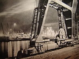
Port of Gdynia – the Polish
seaport located on the western coast of Gdańsk Bay
Baltic sea
in Gdynia
. Founded in 1926. In 2008 it was #2 in containers on the Baltic sea
.
Poland
Poland , officially the Republic of Poland , is a country in Central Europe bordered by Germany to the west; the Czech Republic and Slovakia to the south; Ukraine, Belarus and Lithuania to the east; and the Baltic Sea and Kaliningrad Oblast, a Russian exclave, to the north...
seaport located on the western coast of Gdańsk Bay
Gdansk Bay
Gdańsk Bay or the Bay of Gdańsk or Danzig Bay is a southeastern bay of the Baltic Sea. It is named after the adjacent port city of Gdańsk in Poland and is sometimes referred to as a gulf.-Geography:...
Baltic sea
Baltic Sea
The Baltic Sea is a brackish mediterranean sea located in Northern Europe, from 53°N to 66°N latitude and from 20°E to 26°E longitude. It is bounded by the Scandinavian Peninsula, the mainland of Europe, and the Danish islands. It drains into the Kattegat by way of the Øresund, the Great Belt and...
in Gdynia
Gdynia
Gdynia is a city in the Pomeranian Voivodeship of Poland and an important seaport of Gdańsk Bay on the south coast of the Baltic Sea.Located in Kashubia in Eastern Pomerania, Gdynia is part of a conurbation with the spa town of Sopot, the city of Gdańsk and suburban communities, which together...
. Founded in 1926. In 2008 it was #2 in containers on the Baltic sea
Baltic Sea
The Baltic Sea is a brackish mediterranean sea located in Northern Europe, from 53°N to 66°N latitude and from 20°E to 26°E longitude. It is bounded by the Scandinavian Peninsula, the mainland of Europe, and the Danish islands. It drains into the Kattegat by way of the Øresund, the Great Belt and...
.
Trans-shipments
- 1924 - 10,000 tons
- 1929 - 2,923,000 tons
- 1938 - 8,700,000 tons
- 2002 - 9,365,200 tons
- 2005 - 12,230,700 tons
- 2006 - 14,200,000 tons
- Containers 461 170
- Passengers 364,202
External links
- Port of Gdynia website
- AISAutomatic Identification SystemThe Automatic Identification System is an automatic tracking system used on ships and by Vessel traffic services for identifying and locating vessels by electronically exchanging data with other nearby ships and AIS Base stations...
live vessel traffic in Port of Gdynia- Google EarthGoogle EarthGoogle Earth is a virtual globe, map and geographical information program that was originally called EarthViewer 3D, and was created by Keyhole, Inc, a Central Intelligence Agency funded company acquired by Google in 2004 . It maps the Earth by the superimposition of images obtained from satellite...
plugin
- Google Earth