

Ponce Historic Zone
Encyclopedia
Ponce, Puerto Rico
Ponce is both a city and a municipality in the southern part of Puerto Rico. The city is the seat of the municipal government.The city of Ponce, the fourth most populated in Puerto Rico, and the most populated outside of the San Juan metropolitan area, is named for Juan Ponce de León y Loayza, the...
with construction that dates to the late nineteenth and early twentieth centuries. The zone was originally designated in 1962, and then it only included the center core of the city, but it has since been expanded to include a much larger area. On November 17, 2005, then-Governor of Puerto Rico, Aníbal Acevedo Vilá
Aníbal Acevedo Vilá
Aníbal Salvador Acevedo Vilá is a Puerto Rican politician and lawyer. He served as the eighth Governor of the Commonwealth of Puerto Rico, a Commonwealth of the United States, from 2005 to 2009. He is a Harvard University alumnus and a graduate of the University of Puerto Rico School of Law,...
, signed Executive Order Number 72, approving the historic Ponce center as a Historic Center of First Order. The zone goes by various names, including Ponce Tradicional (Traditional Ponce), Ponce Centro (Ponce Center), Ponce Historico (Historic Ponce), and Distrito Historico (Historic District).
Location
The zone is located in what is commonly called Ponce Pueblo ("Ponce Town") – the central downtown and oldest area of the city. While there are several roads that lead to it, the most typical point of entry is via PR-1Puerto Rico Highway 1
Puerto Rico Highway 1 connects the city of Ponce to San Juan. Leaving Ponce, the road follows somewhat parallel along the southern coast of the island and, at Salinas, it turns north to cut through the Cordillera Central in its approach to San Juan....
which, at its southern terminus, becomes Lolita Tizol street and turns into Isabel II street, leading to the heart of Ponce at the Plaza Las Delicias
Plaza Las Delicias
Plaza Las Delicias is the main plaza in the city of Ponce, Puerto Rico. The square is notable for its fountains and for the various monuments it contains. The historic Parque de Bombas and Ponce Cathedral buildings are located within Plaza Las Delicias. Plaza Las Delicias is actually composed of...
. A map of the area covered by the Ponce Historic Zone is available from the government of the municipality of Ponce.
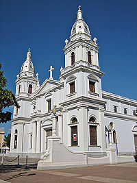
In addition to Plaza Las Delicias with its unique Parque de Bombas
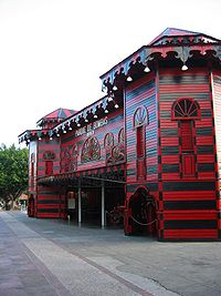
Parque de Bombas
Parque de Bombas is a historic firehouse building in Ponce, Puerto Rico. It is one of Puerto Rico's most notable buildings, with some considering it "by far the most easily recognized landmark in the Island". It is located at the Plaza Las Delicias town square, directly behind the Ponce Cathedral...
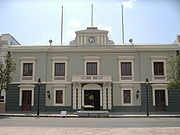
and Nuestra Señora de la Guadalupe Cathedral, the zone includes landmarks such as City Hall
Ponce City Hall
The Ponce City Hall is located on Calle Degetau, across from Plaza Las Delicias in the Ponce Historic Zone in Ponce, Puerto Rico. The building serves as the seat of the executive branch of government of the Autonomous Municipality of Ponce, including the office of the Mayor of Ponce. It is the...
, Armstrong-Poventud Residence
Armstrong-Poventud Residence
Residencia Armstrong-Poventud is a historic building located in the Ponce Historic Zone in Ponce, Puerto Rico. The construction of this home set the stage for the construction of other homes of similar architectural elements, character and opulence in turn-of-the-twentieth-century Ponce...
, Ponce High School
Ponce High School
The Ponce High School is public educational institution in Ponce, Puerto Rico, offering grades ten through twelve. The school's main building is a historic structure located on Cristina Street, in the Ponce Historic Zone. From its beginning the school has secured a unique place in Puerto Rico's...
, and Panteón Nacional Román Baldorioty de Castro
Panteón Nacional Román Baldorioty de Castro
The Panteón Nacional Román Baldorioty de Castro is a tract of land in Barrio Segundo of the city of Ponce, Puerto Rico, originally designed as the city's cemetery, but later converted into what has come to be a famous burial place. Established in 1842, it is Puerto Rico's first national pantheon...
. Numerous other attractions in this historic area are listed in the NRHP, such as Banco de Ponce
Banco de Ponce (building)
The Banco de Ponce building, a historic building in Ponce, Puerto Rico, was the first and main office of Banco de Ponce until the company merged with Banco Popular in 1990. Though its headquarters had moved to a presumptous building in Hato Rey's Milla de Oro by then, Banco de Ponce continued to...
, Casa Paoli
Casa Paoli
Casa Paoli on 2648 Mayor Street, Ponce, Puerto Rico, is nationally significant as the birthplace of Antonio Emilio Paoli y Marcano , a tenor who was the "first Puerto Rican to reach international recognition in the performing arts" and one of the most outstanding opera singers of all times...
, and Casa de la Masacre. Others, such as Teatro Fox Delicias, Teatro La Perla, Plaza del Mercado, and Paseo Atocha
Paseo Atocha
Paseo Atocha is a pedestrian mall in the Ponce Historic Zone, a historic district in Ponce, Puerto Rico. For over a century Paseo Atocha was a commercial street opened to motor vehicle traffic. The street, which is now pedestrian-only, stretches over four blocks from Isabel Street to Vives Street...
are not listed but possess significant historical value. Street corners in most of this zone have chamfer
Chamfer
A chamfer is a beveled edge connecting two surfaces. If the surfaces are at right angles, the chamfer will typically be symmetrical at 45 degrees. A fillet is the rounding off of an interior corner. A rounding of an exterior corner is called a "round" or a "radius"."Chamfer" is a term commonly...
ed corners (Spanish
Spanish language
Spanish , also known as Castilian , is a Romance language in the Ibero-Romance group that evolved from several languages and dialects in central-northern Iberia around the 9th century and gradually spread with the expansion of the Kingdom of Castile into central and southern Iberia during the...
: esquinas de chaflán), typical of Barcelona, Spain.
Ponce en Marcha
In recent years an intensive $440 million revitalization project called "Ponce en Marcha" ("Ponce on the Move") has increased the city's historic area from 260 to 1,046 buildings. The Ponce en Marcha project was conceived in 1985 by then governor Rafael Hernández ColónRafael Hernández Colón
Rafael Hernández Colón is a Puerto Rican politician who served as the fourth Governor of the Commonwealth of Puerto Rico for three non-consecutive terms, from 1973 to 1977 and from 1985 to 1993. An experienced politician, Hernández holds the record for being the youngest Governor of Puerto Rico,...
during his second term in La Fortaleza
La Fortaleza
La Fortaleza is the current official residence of the Governor of Puerto Rico. It was built between 1533 and 1540 to defend the harbor of San Juan. The structure is also known as Palacio de Santa Catalina . It is the oldest executive mansion in the New World...
. A significant number of buildings in Ponce are listed in the National Register of Historic Places
National Register of Historic Places listings in southern Puerto Rico
This is a list of properties and districts in the southern municipalities of Puerto Rico that are listed on the National Register of Historic Places. It includes places along the southern coast, and on islands, and in the peaks and on the south slope of Puerto Rico's Cordillera Central.The area...
. The nonprofit Project for Public Places listed the historic downtown Ponce city center as one of the 60 of the World's Great Places, for its "graciously preserved showcase of Caribbean culture". The Ponce en Marcha project has given even more form to the definition, establishment, and development of the Ponce Historic Zone. The plan is the result of litigation between the Government of the Autonomous Municipality of Ponce and the Government of Puerto Rico.
The Ponce en Marcha plan projects involve several departments of the Government of Puerto Rico:
- The Puerto Rico Departamento de la ViviendaPublic housing in Puerto RicoPublic housing in Puerto Rico is a subsidized system of housing units, mostly consisting of housing projects , which are provided for low-income families in Puerto Rico...
must complete the "Riberas del Bucaná III" residential project, and rehabilitate housing in the Baldorioty, La Ponderosa, and Lomas de GuaraguaoGuaraguaoGuaraguao is one of the 31 barrios in the municipality of Ponce, Puerto Rico. Along with Anón, Coto Laurel, Marueño, Quebrada Limón, Real, and San Patricio, and the coastal barrios of Canas and Capitanejo, Guaraguao is one of the municipality's nine bordering barrios. It borders the...
sectors. It must rehabilitate the homes in the Puerto Viejo sector in barrio PlayaPlaya (Ponce)La Playa de Ponce, Ponce Playa, La Playa, or simply Playa, is one of the thirty-one barrios that comprise the municipality of Ponce, Puerto Rico. Along with Bucaná, Canas, Vayas, and Capitanejo, Playa is one of the municipality's five coastal barrios...
plus 200 units of uninhabited lots citywide, restart the program "Tu Ciudad Renace", and demolish the housing project "Residencial Las Terrazas". - The Puerto Rico Autoridad de CarreterasPuerto Rico Department of Transportation and Public WorksThe Puerto Rico Department of Transportation and Public Works is a government agency of Puerto Rico regulating transportation and public works. The agency's headquarters are located in San Juan.-External links:*...
must comply with the construction of the bridge at the intersection of PR-2Puerto Rico Highway 2Puerto Rico Highway 2, the longest highway in the Commonwealth of Puerto Rico at about 156 miles long, connects San Juan to Ponce....
and Punto Oro, the two projects required to complete the Anillo de Circunvalación de Ponce, and three bridges over Avenida Maruca. - The Puerto Rico Autoridad de Edificios Públicos, must swap land belonging to the Puerto Rico Police Marine Unit in exchange for improvements to "Parque Julio González", and must complete the construction of the Ponce Headquarters of the Puerto Rico Police.
- The Puerto Rico Autoridad de Energía EléctricaPuerto Rico Electric Power AuthorityThe Puerto Rico Electric Power Authority, originally named the Puerto Rico Water Resources Authority or Autoridad de las Fuentes Fluviales was created by Law #83 of May 2, 1941 during the governorship of Rexford G. Tugwell, an FDR "brain-truster".Publicly-owned, PRWRA unified diverse regional and...
must complete Phase III of the burial of aerial cabling within the "Zona HistóricaPonce Historic ZoneThe Ponce Historic Zone is a historic district in downtown Ponce, Puerto Rico with construction that dates to the late nineteenth and early twentieth centuries. The zone was originally designated in 1962, and then it only included the center core of the city, but it has since been expanded to...
", as well as Phase VI. - The Puerto Rico Autoridad de Acueductos Alcantarillados must complete the design of the water filtration plant at barrio CerrillosCerrillos (Ponce)Cerrillos is one of the 31 barrios of the municipality of Ponce, Puerto Rico. Along with Magueyes, Tibes, Portugués, Monte Llano, Maragüez, and Machuelo Arriba, Cerrillos is one of the municipality's seven rural interior barrios.-Location:...
, the acquisition of land for its construction and its distribution network. - The Puerto Rico Autoridad de los PuertosPuerto Rico Ports AuthorityThe Puerto Rico Ports Authority is a public corporation created by the Legislative Assembly of the United States' Commonwealth of Puerto Rico to develop and operate ports and airports within the Commonwealth...
must expand the runwayRunwayAccording to ICAO a runway is a "defined rectangular area on a land aerodrome prepared for the landing and take-off of aircraft." Runways may be a man-made surface or a natural surface .- Orientation and dimensions :Runways are named by a number between 01 and 36, which is generally one tenth...
and taxiwayTaxiwayA taxiway is a path on an airport connecting runways with ramps, hangars, terminals and other facilities. They mostly have hard surface such as asphalt or concrete, although smaller airports sometimes use gravel or grass....
at Mercedita AirportMercedita AirportMercedita Airport is a commercial airport located three miles east of the central business district of Ponce, Puerto Rico. The airport covers and has one runway. Passenger movement at the airport in FY 2008 was 278,911, an astounding 1,228% increase over fiscal year 2003 and the highest of all...
and build the maintenance building. - The Puerto Rico Departamento de Recursos NaturalesPuerto Rico Department of Natural and Environmental ResourcesThe Puerto Rico Department of Natural and Environmental Resources was created by Law 23 of June 20, 1972, during the governorship of Luis A. Ferré. In 1973, as a gesture of bipartisanship, Ferré's successor, Gov. Rafael Hernández Colón appointed his predecessor's Puerto Rico Environmental Quality...
must comply with the construction of the Portugués and Bucaná rivers lineal parkParque Lineal Veredas del LabradorThe Parque Lineal Veredas del Labrador, also known as just the Parque Lineal and as Veredas del Labrador is a passive park currently under construction in Ponce, Puerto Rico.The park will link to, but it is different from, a neighboring park also currently under construction called Parque Lineal...
, as well as the canalization of the MatildeRío MatildeThe Río Matilde is a short river in the municipality of Ponce, Puerto Rico. It forms from the confluence of Rio Pastillo and Rio Canas This river is one of the 14 rivers in the municipality and, forming at an altitude of just , it is the river forming at the lowest altitute in Ponce.-Origin:At ...
, PastilloRío PastilloRío Pastillo is a river in the municipality of Ponce, Puerto Rico. It is also known as "Rio Marueño". Together with Rio Canas, Rio Pastillo forms Rio Matilde. Rio Pastillo is one of the 14 rivers in the municipality.-Origin:...
y Canas rivers and the development of the La Matilde Natural Reserve and the Caja de Muertos LightCaja de Muertos LightCaja de Muertos Light, is an 1887 lighthouse in Ponce, Puerto Rico, that is unique amongst all other lighthouses in Puerto Rico for its unusual Lorraine cross, double-arm, T-type shape structure. The historic lighthouse is located in Caja de Muertos, an uninhabited island off the coast of Ponce,...
.
Categories
- The first consists of structures "with a monumental historic value", and part of the city’s heritage.
- The second is for those structures that while lacking a monumental historic value, possess some qualities of historic, architectural, or cultural interest.
- The third category includes those structures of contextual value. These are those structures that may not intrinsically possess historic, architectural, or cultural value individually, they but do enhance the area when they are considered contextually, as part of a larger group, as part of urban characteristic, or as part of the architecture of a section of a street.
- And finally, category 4 is reserved for those structures that exist within the historic zone but whose value has not been assessed, that is, they are unclassified.
Sub-zones
- First Order Zone – This zone is limited to the area immediately surrounding Plaza Las DeliciasPlaza Las DeliciasPlaza Las Delicias is the main plaza in the city of Ponce, Puerto Rico. The square is notable for its fountains and for the various monuments it contains. The historic Parque de Bombas and Ponce Cathedral buildings are located within Plaza Las Delicias. Plaza Las Delicias is actually composed of...
. This is the original historic zone, created in 1962. - Second Order Zone – This is a zone that was added in 1989 further increasing the perimeter of the area around Plaza Las Delicias.
- Third Order Zone – This zone was added in 1992, and it covered the communities of Mariani, Belgica, and parts of Clausells, and Cantera. It was also extended, for the first time, east of Rio Portugues, to cover the community of La Alhambra.
In August, 2003, Mayor Cordero favored a measure to exclude Belgica, Claussells, and Cantera—all poor, low-income communities—from the historic zone.