
Point Reyes National Seashore
Encyclopedia
Point Reyes National Seashore is a 71028 acres (287.4 km²) park preserve located on the Point Reyes Peninsula
in Marin County, California
, USA. As a national seashore, it is maintained by the US National Park Service as a nationally important nature preserve within which existing agricultural uses are allowed to continue. Clem Miller, a US Congressman from Marin County
wrote and introduced the bill for the establishment of Point Reyes National Seashore in 1962 to protect the peninsula from residential development which was proposed at the time for the slopes above Drake's Bay. Miller's vision included the continuation of the historic ranching and oyster farming along with the preservation of the grasslands and open scenic vistas. The mix of commercial and recreational uses was the reason the area was designated a National Seashore rather than a National Park. All of the park's beaches were listed as the cleanest in the state in 2010.
Point Reyes was one of the locations where the 1980 horror film The Fog
was filmed.
of the San Andreas Fault
, about half of which is sunk below sea level and forms Tomales Bay
. The fact that the peninsula is on a different tectonic plate than the east shore of Tomales Bay produces a difference in soils and therefore to some extent a noticeable difference in vegetation.
The small town of Point Reyes Station
, although not actually located on the peninsula, nevertheless provides most services to it, though some services are also available at Inverness
on the west shore of Tomales Bay. The even smaller town of Olema, about 3 miles (4.8 km) south of Point Reyes Station, serves as the gateway to the Seashore and its visitor center, located on Bear Valley Road.
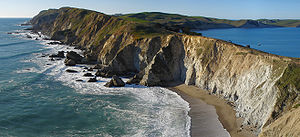
The peninsula includes wild coastal beaches and headlands, estuaries, and uplands, with a coastline that bears a striking resemblance to Cape Point
, Cape of Good Hope
, South Africa
. Although parts of the Seashore are commercially farmed, and parts are under the jurisdiction of other conservation authorities, the National Park Service provides signage and seeks to manage visitor impact on the entire peninsula and virtually all of Tomales Bay. The Seashore also administers the parts of the Golden Gate National Recreation area, such as the Olema Valley, that are adjacent to the Seashore.
The northernmost part of the peninsula is maintained as a reserve for Tule Elk
, which are readily seen there. The preserve is also very rich in raptor
s and shorebirds.
The Point Reyes Lighthouse attracts whale-watchers
looking for the Gray Whale
migrating south in mid-January and north in mid-March.
The Point Reyes Lifeboat Station
is a National Historic Landmark
. It is the last remaining example of a rail launched lifeboat station that was common on the Pacific coast.
Kule Loklo
, a recreated Coast Miwok
village, is a short walk from the visitor center.
More than 30000 acres (121.4 km²) of the Point Reyes National Seashore are designated as the Phillip Burton Wilderness
, named in honor of California Congressman Phillip Burton
, who wrote the legislation creating the Golden Gate National Recreation Area
and was instrumental in helping to pass the California Wilderness Act of 1984
.
The Point Reyes National Seashore attracts 2.5 million visitors annually. Hostelling International USA (part of Hostelling International
) maintains a 45 bed youth hostel
at the Seashore.
Across the parking lot at the Visitor's Center is the Earthquake Trail which is a 0.6 mile (0.965604 km) loop that runs directly over the San Andreas Fault, deep underground, so that it is possible to stand straddling the fault line. The trail provides descriptions of the fault and the surrounding geology, and there is a fence that was pulled 18 feet (5.5 m) apart during the 1906 San Francisco Earthquake.
At the western end of the Point Reyes Peninsula is the historic Point Reyes Lighthouse, reached by descending 308 steps. Unlike many lighthouses, that were built high so the light could be seen by ships far out to sea, the Point Reyes lighthouse was built low to get the light below the fog that is so prevalent in the area. Nearby is the short Chimney Rock hike, which is noted for its spring wildflower displays.
As befitting a national seashore, Point Reyes offers several beach walks. Limantour Spit winds up on a narrow sandy beach, from which Drakes Beach can be glimpsed across Drakes Bay
. North Beach and South Beach are often windswept and wave-pounded. Ocean vistas from higher ground can be seen from the Tomales Point Trail and, to the south, from the Palomarin trailhead at the park's southern entrance outside the town of Bolinas
.
For backpackers
, Point Reyes has four hike-in campgrounds available by reservation.
Point Reyes is a terminus of the American Discovery Trail
which is the only transcontinental trail in the United States.
ecoregion
.
In his book The Natural History of the Point Reyes Peninsula, Jules Evens identifies several plant communities. One of the most prominent is the Coastal Douglas-fir (Pseudotsuga menziesii) forest, which includes Coast live oak
, Tanoak
, and California bay and reaches across the southern half of Inverness Ridge toward Bolinas Lagoon
. Unlogged parts of this Douglas-fir forest contain trees over 300 years old and up to 6 feet (1.8 m) in diameter. But despite these large, old trees, the forest may nevertheless be a result of European settlement. The Coast Miwok
people who once lived in the area set frequent fires to clear brush and increase game animal populations, and early explorers' accounts describe the hills as bare and grassy. But as the Native American settlements were replaced by European ones from the seventeenth century onward, the forests expanded as fire frequency decreased, resulting in the forests we see today.
The Bishop pine
(Pinus muricata) forest is found on slopes in the northern half of the park. Many of these trees growing in thick swaths came from seeds released after the 1995 Mt. Vision fire.
Salt, brackish, and freshwater marshlands are found adjacent to Drakes Estero
and Abbotts Lagoon
. The other communities identified by Evens are the coastal strand, dominated by European beach grass (Ammophila arenaria
), ice plant
(Carprobrotus edulis, also called sea fig or Hottentot fig), sea rocket (Cakile maritima) and other species that thrive on the immediate coast; northern coastal prairie
, found on a narrow strip just inland from the coastal strand that includes some native grasses; coastal rangeland, the area still grazed by the cattle from the peninsula's remaining working ranches; northern coastal scrub
, dominated by coyote bush (Baccharis pilularis); and the intertidal and subtidal plant communities.
Point Reyes is home to the only known population of the endangered Sonoma spineflower, Chorizanthe valida
.
s at Point Reyes National Seashore uses Toyota RAV4
electric vehicle
s. Because these RAVs are powered by the electric solar arrays on park building
s, they provide true zero-emission, zero-carbon, zero-petroleum transportation, helping meet the Park's environmental goals.
Point Reyes
Point Reyes is a prominent cape on the Pacific coast of northern California. It is located in Marin County approximately WNW of San Francisco. The term is often applied to the Point Reyes Peninsula, the region bounded by Tomales Bay on the northeast and Bolinas Lagoon on the southeast...
in Marin County, California
Marin County, California
Marin County is a county located in the North San Francisco Bay Area of the U.S. state of California, across the Golden Gate Bridge from San Francisco. As of 2010, the population was 252,409. The county seat is San Rafael and the largest employer is the county government. Marin County is well...
, USA. As a national seashore, it is maintained by the US National Park Service as a nationally important nature preserve within which existing agricultural uses are allowed to continue. Clem Miller, a US Congressman from Marin County
Marin County, California
Marin County is a county located in the North San Francisco Bay Area of the U.S. state of California, across the Golden Gate Bridge from San Francisco. As of 2010, the population was 252,409. The county seat is San Rafael and the largest employer is the county government. Marin County is well...
wrote and introduced the bill for the establishment of Point Reyes National Seashore in 1962 to protect the peninsula from residential development which was proposed at the time for the slopes above Drake's Bay. Miller's vision included the continuation of the historic ranching and oyster farming along with the preservation of the grasslands and open scenic vistas. The mix of commercial and recreational uses was the reason the area was designated a National Seashore rather than a National Park. All of the park's beaches were listed as the cleanest in the state in 2010.
Point Reyes was one of the locations where the 1980 horror film The Fog
The Fog
The Fog is a 1980 horror film directed by John Carpenter, who also co-wrote the screenplay and composed the music for the film. It stars Adrienne Barbeau, Jamie Lee Curtis, Tom Atkins and Janet Leigh...
was filmed.
Description
The Point Reyes peninsula is a well defined area, geologically separated from the rest of Marin County and almost all of the continental United States by a rift zoneRift zone
A rift zone is a feature of some volcanoes, especially the shield volcanoes of Hawaii, in which a linear series of fissures in the volcanic edifice allows lava to be erupted from the volcano's flank instead of from its summit...
of the San Andreas Fault
San Andreas Fault
The San Andreas Fault is a continental strike-slip fault that runs a length of roughly through California in the United States. The fault's motion is right-lateral strike-slip...
, about half of which is sunk below sea level and forms Tomales Bay
Tomales Bay
Tomales Bay is a long narrow inlet of the Pacific Ocean in Marin County in northern California in the United States. It is approximately 15 miles long and averages nearly 1.0 miles wide, effectively separating the Point Reyes Peninsula from the mainland of Marin County. It is located...
. The fact that the peninsula is on a different tectonic plate than the east shore of Tomales Bay produces a difference in soils and therefore to some extent a noticeable difference in vegetation.
The small town of Point Reyes Station
Point Reyes Station, California
Point Reyes Station is small unincorporated town located in western Marin County, California. Point Reyes Station is located south-southeast of Tomales, at an elevation of . Point Reyes Station is located along State Route 1 and is a gateway to the Point Reyes National Seashore, an extremely...
, although not actually located on the peninsula, nevertheless provides most services to it, though some services are also available at Inverness
Inverness, California
Inverness is an unincorporated community and census-designated place located in western Marin County, California. Inverness is located on the southwest shore of Tomales Bay northwest of Point Reyes Station, at an elevation of 43 feet . In the 2010 census, the population was 1,304...
on the west shore of Tomales Bay. The even smaller town of Olema, about 3 miles (4.8 km) south of Point Reyes Station, serves as the gateway to the Seashore and its visitor center, located on Bear Valley Road.
The peninsula includes wild coastal beaches and headlands, estuaries, and uplands, with a coastline that bears a striking resemblance to Cape Point
Cape Point
Cape Point is a promontory at the southeast corner of the Cape Peninsula, which is a mountainous and scenic landform that runs north-south for about thirty kilometres at the extreme southwestern tip of the African continent in the Republic of South Africa. Table Mountain and the city of Cape Town...
, Cape of Good Hope
Cape of Good Hope
The Cape of Good Hope is a rocky headland on the Atlantic coast of the Cape Peninsula, South Africa.There is a misconception that the Cape of Good Hope is the southern tip of Africa, because it was once believed to be the dividing point between the Atlantic and Indian Oceans. In fact, the...
, South Africa
South Africa
The Republic of South Africa is a country in southern Africa. Located at the southern tip of Africa, it is divided into nine provinces, with of coastline on the Atlantic and Indian oceans...
. Although parts of the Seashore are commercially farmed, and parts are under the jurisdiction of other conservation authorities, the National Park Service provides signage and seeks to manage visitor impact on the entire peninsula and virtually all of Tomales Bay. The Seashore also administers the parts of the Golden Gate National Recreation area, such as the Olema Valley, that are adjacent to the Seashore.
The northernmost part of the peninsula is maintained as a reserve for Tule Elk
Tule Elk
The tule elk is a subspecies of elk found only in California, ranging from the grasslands and marshlands of the Central Valley to the grassy hills on the coast. The subspecies name derives from the tule that it feeds off of, which grows in the marshlands...
, which are readily seen there. The preserve is also very rich in raptor
Bird of prey
Birds of prey are birds that hunt for food primarily on the wing, using their keen senses, especially vision. They are defined as birds that primarily hunt vertebrates, including other birds. Their talons and beaks tend to be relatively large, powerful and adapted for tearing and/or piercing flesh....
s and shorebirds.
The Point Reyes Lighthouse attracts whale-watchers
Whale watching
Whale watching is the practice of observing whales and other cetaceans in their natural habitat. Whales are watched most commonly for recreation but the activity can also serve scientific or educational purposes. A 2009 study, prepared for IFAW, estimated that 13 million people went whale watching...
looking for the Gray Whale
Gray Whale
The gray whale, Eschrichtius robustus, is a baleen whale that migrates between feeding and breeding grounds yearly. It reaches a length of about , a weight of , and lives 50–70 years. The common name of the whale comes from the gray patches and white mottling on its dark skin. Gray whales were...
migrating south in mid-January and north in mid-March.
The Point Reyes Lifeboat Station
Point Reyes Lifeboat Station
Point Reyes Lifeboat Station, also known as Point Reyes Lifeboat Rescue Station, was built in 1927 by the United States Lifesaving Service . It used rail launched 36 foot motorized lifeboats to aid ships foundering on Point Reyes. It was a replacement to another station that was built in 1888...
is a National Historic Landmark
National Historic Landmark
A National Historic Landmark is a building, site, structure, object, or district, that is officially recognized by the United States government for its historical significance...
. It is the last remaining example of a rail launched lifeboat station that was common on the Pacific coast.
Kule Loklo
Kule Loklo
Kule Loklo is a recreated Coast Miwok Native American village located a short walk from the visitor center of the Point Reyes National Seashore, in Marin County, California...
, a recreated Coast Miwok
Coast Miwok
The Coast Miwok were the second largest group of Miwok Native American people. The Coast Miwok inhabited the general area of modern Marin County and southern Sonoma County in Northern California, from the Golden Gate north to Duncans Point and eastward to Sonoma Creek...
village, is a short walk from the visitor center.
More than 30000 acres (121.4 km²) of the Point Reyes National Seashore are designated as the Phillip Burton Wilderness
Phillip Burton Wilderness
The Phillip Burton Wilderness is part of the Point Reyes National Seashore located about northeast of San Francisco, California. Total wilderness land is 33,373 acres which includes a roadless "potential wilderness" area of over and is the only designated wilderness along the California coast...
, named in honor of California Congressman Phillip Burton
Phillip Burton
Phillip Burton was a United States Representative from California. A Democrat, he was instrumental in creating the Golden Gate National Recreation Area. Burton was one of the first members of Congress to acknowledge the need for AIDS research and introduce an AIDS bill. He was the brother of...
, who wrote the legislation creating the Golden Gate National Recreation Area
Golden Gate National Recreation Area
The Golden Gate National Recreation Area is a U.S. National Recreation Area administered by the National Park Service that surrounds the San Francisco Bay area. It is one of the most visited units of the National Park system in the United States, with over 13 million visitors a year...
and was instrumental in helping to pass the California Wilderness Act of 1984
California Wilderness Act of 1984
The California Wilderness Act of 1984 is a federal law , passed by the United States Congress on September 28, 1984, that authorized the addition of over within the state of California to the National Wilderness Preservation System....
.
The Point Reyes National Seashore attracts 2.5 million visitors annually. Hostelling International USA (part of Hostelling International
Hostelling International
Hostelling International, formerly known as International Youth Hostel Federation , is the federation of more than 90 national youth hostel associations in more than 80 countries who have over 4,500 affiliated hostels around the world....
) maintains a 45 bed youth hostel
Hostel
Hostels provide budget oriented, sociable accommodation where guests can rent a bed, usually a bunk bed, in a dormitory and share a bathroom, lounge and sometimes a kitchen. Rooms can be mixed or single-sex, although private rooms may also be available...
at the Seashore.
Hiking
Point Reyes has an excellent system of hiking trails for dayhiking and backpacking. Bear Valley Trail is the most popular hike in the park. Taking off from the visitor's center, it travels mostly streamside through a shaded, fern-laden canyon, breaking out at Divide Meadow before heading gently downward to the coast, where it emerges at the spectacular ocean view at Arch Rock. Three trails connecting from the west with the Bear Valley trail head upward toward Mt. Wittenberg, at 1407 feet (429 m), the highest point in the park.Across the parking lot at the Visitor's Center is the Earthquake Trail which is a 0.6 mile (0.965604 km) loop that runs directly over the San Andreas Fault, deep underground, so that it is possible to stand straddling the fault line. The trail provides descriptions of the fault and the surrounding geology, and there is a fence that was pulled 18 feet (5.5 m) apart during the 1906 San Francisco Earthquake.
At the western end of the Point Reyes Peninsula is the historic Point Reyes Lighthouse, reached by descending 308 steps. Unlike many lighthouses, that were built high so the light could be seen by ships far out to sea, the Point Reyes lighthouse was built low to get the light below the fog that is so prevalent in the area. Nearby is the short Chimney Rock hike, which is noted for its spring wildflower displays.
As befitting a national seashore, Point Reyes offers several beach walks. Limantour Spit winds up on a narrow sandy beach, from which Drakes Beach can be glimpsed across Drakes Bay
Drakes Bay
Drakes Bay is a small bay on the coast of northern California in the United States, approximately 30 miles northwest of San Francisco at approximately 38 degrees north latitude. The bay is approximately 8 miles wide...
. North Beach and South Beach are often windswept and wave-pounded. Ocean vistas from higher ground can be seen from the Tomales Point Trail and, to the south, from the Palomarin trailhead at the park's southern entrance outside the town of Bolinas
Bolinas, California
Bolinas formerly Juggville is a coastal unincorporated community in Marin County, California in the San Francisco Bay Area. Bolinas is located west-southwest of San Rafael, at an elevation of 36 feet...
.
For backpackers
Backpacking (wilderness)
Backpacking combines the activities of hiking and camping for an overnight stay in backcountry wilderness...
, Point Reyes has four hike-in campgrounds available by reservation.
Point Reyes is a terminus of the American Discovery Trail
American Discovery Trail
The American Discovery Trail is a coast-to-coast hiking and biking trail across the mid-tier of the United States. It starts on the Delmarva Peninsula on the Atlantic Ocean and ends on the northern California coast on the Pacific Ocean, and is signed on over of trail. This includes the doubled...
which is the only transcontinental trail in the United States.
Flora
Point Reyes lies within the California interior chaparral and woodlandsCalifornia interior chaparral and woodlands
The California interior chaparral and woodlands ecoregion covers in an elliptical ring around the California Central Valley. It occurs on hills and mountains ranging from to . It is part of the Mediterranean forests, woodlands, and scrub biome, with cool, wet winters and hot, dry summers...
ecoregion
Ecoregion
An ecoregion , sometimes called a bioregion, is an ecologically and geographically defined area that is smaller than an ecozone and larger than an ecosystem. Ecoregions cover relatively large areas of land or water, and contain characteristic, geographically distinct assemblages of natural...
.
In his book The Natural History of the Point Reyes Peninsula, Jules Evens identifies several plant communities. One of the most prominent is the Coastal Douglas-fir (Pseudotsuga menziesii) forest, which includes Coast live oak
Coast Live Oak
Quercus agrifolia, the Coast Live Oak, is an evergreen oak , native to the California Floristic Province. It grows west of the Sierra Nevada from Mendocino County, California, south to northern Baja California in Mexico. It is classified in the red oak section Quercus agrifolia, the Coast Live Oak,...
, Tanoak
Tanoak
Tanoak, formerly known taxonomically as Lithocarpus densiflorus, was recently moved into a new genus, Notholithocarpus, based on multiple lines of evidence....
, and California bay and reaches across the southern half of Inverness Ridge toward Bolinas Lagoon
Bolinas Lagoon
Bolinas Lagoon is a tidal estuary, approximately in area, located at in the West Marin region of Marin County, California, United States. It is a part of the Gulf of the Farallones National Marine Sanctuary. The lagoon is a back bay of Bolinas Bay on the Pacific coast approximately 15 mi ...
. Unlogged parts of this Douglas-fir forest contain trees over 300 years old and up to 6 feet (1.8 m) in diameter. But despite these large, old trees, the forest may nevertheless be a result of European settlement. The Coast Miwok
Coast Miwok
The Coast Miwok were the second largest group of Miwok Native American people. The Coast Miwok inhabited the general area of modern Marin County and southern Sonoma County in Northern California, from the Golden Gate north to Duncans Point and eastward to Sonoma Creek...
people who once lived in the area set frequent fires to clear brush and increase game animal populations, and early explorers' accounts describe the hills as bare and grassy. But as the Native American settlements were replaced by European ones from the seventeenth century onward, the forests expanded as fire frequency decreased, resulting in the forests we see today.
The Bishop pine
Bishop Pine
The Bishop Pine, Pinus muricata, is a pine with a very restricted range: mostly in the U.S. state of California, including several offshore Channel Islands, and a few locations in Baja California, Mexico...
(Pinus muricata) forest is found on slopes in the northern half of the park. Many of these trees growing in thick swaths came from seeds released after the 1995 Mt. Vision fire.
Salt, brackish, and freshwater marshlands are found adjacent to Drakes Estero
Drakes Estero
Drakes Estero is an expansive estuary in Marin County on the Pacific coast of northern California in the United States, approximately northwest of San Francisco.Located at , the estuary provides the main drainage for the Point Reyes peninsula...
and Abbotts Lagoon
Abbotts Lagoon
Abbotts Lagoon is a two-stage lagoon near the western coast of the Point Reyes National Seashore. The upper lagoon is a fresh water impoundment which overflows into a lower brackish level with occasional winter tidal exchange...
. The other communities identified by Evens are the coastal strand, dominated by European beach grass (Ammophila arenaria
Ammophila arenaria
Ammophila arenaria is a species of grass known by the common names European Marram Grass and European Beachgrass. It is one of two species of the genus Ammophila . It is native to the coastlines of Europe and North Africa where it grows in the sands of beach dunes. It is a perennial grass forming...
), ice plant
Ice plant
- Plant common names :* Aizoaceae, the ice plant family* Carpobrotus chilensis* Carpobrotus edulis* Conicosia, narrow-leafed ice plants* Delosperma cooperi, Cooper's ice plant* Delosperma bosseranum...
(Carprobrotus edulis, also called sea fig or Hottentot fig), sea rocket (Cakile maritima) and other species that thrive on the immediate coast; northern coastal prairie
California coastal prairie
California coastal prairie, also known as northern coastal grassland, is a grassland plant community of California and Oregon in the Temperate grasslands, savannas, and shrublands Biome...
, found on a narrow strip just inland from the coastal strand that includes some native grasses; coastal rangeland, the area still grazed by the cattle from the peninsula's remaining working ranches; northern coastal scrub
Northern coastal scrub
Northern coastal scrub is a scrubland plant community of California and Oregon. It occurs along the Pacific Coast from Point Sur on the Central California coast in Monterey County, California, to southern Oregon...
, dominated by coyote bush (Baccharis pilularis); and the intertidal and subtidal plant communities.
Point Reyes is home to the only known population of the endangered Sonoma spineflower, Chorizanthe valida
Chorizanthe valida
Chorizanthe valida is a rare species of flowering plant in the buckwheat family known by the common name Sonoma spineflower. It is endemic to West Marin, Marin County, California, where it is known from only one remaining natural population at Point Reyes National Seashore...
.
Electric vehicles
The park rangerPark ranger
A park ranger or forest ranger is a person entrusted with protecting and preserving parklands – national, state, provincial, or local parks. Different countries use different names for the position. Ranger is the favored term in the United States, Canada, and the United Kingdom. Within the United...
s at Point Reyes National Seashore uses Toyota RAV4
Toyota RAV4
The Toyota RAV4 is a compact crossover SUV from Toyota. It was the first compact crossover SUV, introduced in Japan and Europe in 1994 and beginning sales in North America in 1996...
electric vehicle
Electric vehicle
An electric vehicle , also referred to as an electric drive vehicle, uses one or more electric motors or traction motors for propulsion...
s. Because these RAVs are powered by the electric solar arrays on park building
Park Building
Park Building is a historic building in Worcester, Massachusetts.It was built in 1914 and added to the National Register of Historic Places in 1980.It is currently tied as the 11th tallest building in Worcester....
s, they provide true zero-emission, zero-carbon, zero-petroleum transportation, helping meet the Park's environmental goals.
External links
- National Parks Service official website about Point Reyes
- West Marin Chamber of Commerce site about Point Reyes
- Point Reyes National Seashore Association, a nonprofit organization working in coordination with the National Park Service.
- Kule Loklo, a recreation of a Coast Miwok Indian village
- A Weekend and Recreation Guide to Point Reyes and West Marin
- Point Reyes Hiking