

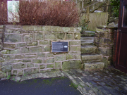
Pinfold
Encyclopedia

Great Britain
Great Britain or Britain is an island situated to the northwest of Continental Europe. It is the ninth largest island in the world, and the largest European island, as well as the largest of the British Isles...
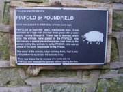
, is an area where stray animals were rounded up if their owners failed to properly supervise their use of common grazing land. A mulct (fine) had to be paid for their release.
An alternative spelling/pronunciation was "poundfield", which implies a relation to the modern English word "(im)pound".
The terms "pinfold" and "pound" are Saxon in origin. "Pundfald" and "pund" both mean an enclosure. There appears to be no difference between a pinfold and a village pound
Pound (village)
The Village pound was a feature of most British medieval villages.A high walled and lockable structure it served several purposes; the most common use was to hold stray sheep, pigs and cattle until they were claimed by the owners, usually for the payment of a fine or levy. The pound could be as...
. The term pinfold seems to be more popular in the north and east of the UK whilst in the south and west the term pound is more popular.
Originally built to hold animals which were found straying from their owners land or were found grazing on the common without common rights. The animals would not be released until a fine had been paid to the "pinder" who was an officer of the lord of the manor. Breaking into the pinfold to release the animals was an offence punishable by a fine and/or imprisonment. They were also used by drovers taking their stock to market. The pinfold was used to pen the animals overnight for a small fee.
The size and shape of pinfolds varies, some are four sided: rectangular, square and irregular, others are circular. In size they vary from a few square metres to over 0.5 ha. Pinfolds are known to date from the medieval period. By the 16th century most villages and townships would have had a pinfold. Most of what remains today would date from the 16th and 17th centuries. Some, like Tockholes Pinfold in Lancashire are listed buildings but most have fallen into disrepair.
The artist Andy Goldsworthy
Andy Goldsworthy
Andy Goldsworthy, OBE is a British sculptor, photographer and environmentalist producing site-specific sculpture and land art situated in natural and urban settings. He lives and works in Scotland.-Life and career:The son of F...
has produced a series of sculptures in several of the pinfolds in Cumbria.
See also
- Pinfold, Lancashire — a hamlet in the civil parishCivil parishIn England, a civil parish is a territorial designation and, where they are found, the lowest tier of local government below districts and counties...
of ScarisbrickScarisbrickScarisbrick is a village and civil parish in West Lancashire, England. It is spread out along the A570 so there is no real village centre, though the junction with the A5147 is close to the geographic centre...
, LancashireLancashireLancashire is a non-metropolitan county of historic origin in the North West of England. It takes its name from the city of Lancaster, and is sometimes known as the County of Lancaster. Although Lancaster is still considered to be the county town, Lancashire County Council is based in Preston... - PoundPound (village)The Village pound was a feature of most British medieval villages.A high walled and lockable structure it served several purposes; the most common use was to hold stray sheep, pigs and cattle until they were claimed by the owners, usually for the payment of a fine or levy. The pound could be as...
- Village lock-upVillage lock-upVillage lock-ups are historic buildings that were used for the temporary detention of people in rural parts of England and Wales. They were often used for the confinement of drunks who were usually released the next day or to hold people being brought before the local magistrate. A typical village...
- List of extant pinfolds in Cheshire
External links
- Google maps aerial view of a pinfold in HoughamHougham, LincolnshireHougham is a village and civil parish in the South Kesteven district of Lincolnshire, England. It once had its own Hougham railway station on the line between Grantham and Newark...
, LincolnshireLincolnshireLincolnshire is a county in the east of England. It borders Norfolk to the south east, Cambridgeshire to the south, Rutland to the south west, Leicestershire and Nottinghamshire to the west, South Yorkshire to the north west, and the East Riding of Yorkshire to the north. It also borders...