

Phillips County, Kansas
Encyclopedia
Phillips County is a county located in the U.S. state
of Kansas
. As of the 2010 census, the county population was 5,642. The largest city and county seat
is Phillipsburg
.
, county until 1996, when voters approved the sale of alcoholic liquor by the individual drink with a 30% food sales requirement.
 As of the census
of 2000, there were 6,001 people, 2,496 households, and 1,722 families residing in the county. The population density
was 7 people per square mile (3/km²). There were 3,088 housing units at an average density of 4 per square mile (1/km²). The racial makeup of the county was 98.25% White
, 0.25% Black
or African American
, 0.30% Native American
, 0.45% Asian
, 0.03% from other races
, and 0.72% from two or more races. 0.67% of the population were Hispanic
or Latino
of any race.
There were 2,496 households out of which 28.30% had children under the age of 18 living with them, 61.50% were married couples
living together, 5.50% had a female householder with no husband present, and 31.00% were non-families. 28.60% of all households were made up of individuals and 15.80% had someone living alone who was 65 years of age or older. The average household size was 2.35 and the average family size was 2.89.
In the county the population was spread out with 24.50% under the age of 18, 5.70% from 18 to 24, 23.20% from 25 to 44, 24.80% from 45 to 64, and 21.80% who were 65 years of age or older. The median age was 42 years. For every 100 females there were 94.80 males. For every 100 females age 18 and over, there were 91.20 males.
The median income for a household in the county was $35,013, and the median income for a family was $41,638. Males had a median income of $29,609 versus $17,827 for females. The per capita income
for the county was $17,121. About 7.20% of families and 10.00% of the population were below the poverty line, including 11.60% of those under age 18 and 8.80% of those age 65 or over.
. The city of Phillipsburg
is considered governmentally independent and is excluded from the census figures for the townships. In the following table, the population center is the largest city (or cities) included in that township's population total, if it is of a significant size.
General county information
County Level Data
Maps
U.S. state
A U.S. state is any one of the 50 federated states of the United States of America that share sovereignty with the federal government. Because of this shared sovereignty, an American is a citizen both of the federal entity and of his or her state of domicile. Four states use the official title of...
of Kansas
Kansas
Kansas is a US state located in the Midwestern United States. It is named after the Kansas River which flows through it, which in turn was named after the Kansa Native American tribe, which inhabited the area. The tribe's name is often said to mean "people of the wind" or "people of the south...
. As of the 2010 census, the county population was 5,642. The largest city and county seat
County seat
A county seat is an administrative center, or seat of government, for a county or civil parish. The term is primarily used in the United States....
is Phillipsburg
Phillipsburg, Kansas
Phillipsburg is a city in and the county seat of Phillips County, Kansas, United States. As of the 2010 census, the city population was 2,581.-19th century:...
.
Law and government
Following amendment to the Kansas Constitution in 1986, the county remained a prohibition, or "dry"Dry county
A dry county is a county in the United States whose government forbids the sale of alcoholic beverages. Some prohibit off-premises sale, some prohibit on-premises sale, and some prohibit both. Hundreds of dry counties exist across the United States, almost all of them in the South...
, county until 1996, when voters approved the sale of alcoholic liquor by the individual drink with a 30% food sales requirement.
Geography
According to the 2000 census, the county has a total area of 894.81 square miles (2,317.5 km²), of which 886.23 square miles (2,295.3 km²) (or 99.04%) is land and 8.58 square miles (22.2 km²) (or 0.96%) is water.Adjacent counties
- Harlan CountyHarlan County, Nebraska-History:Prior to 1870, the portion of the Republican valley that now includes Harlan County was a prized hunting ground for the Native Americans; and the threat of attack deterred white settlement in the area...
, NebraskaNebraskaNebraska is a state on the Great Plains of the Midwestern United States. The state's capital is Lincoln and its largest city is Omaha, on the Missouri River....
(north) - Franklin CountyFranklin County, Nebraska-Demographics:As of the census of 2000, there were 3,574 people, 1,485 households, and 1,021 families residing in the county. The population density was 6 people per square mile . There were 1,746 housing units at an average density of 3 per square mile...
, NebraskaNebraskaNebraska is a state on the Great Plains of the Midwestern United States. The state's capital is Lincoln and its largest city is Omaha, on the Missouri River....
(northeast) - Smith CountySmith County, KansasSmith County is a county located in the U.S. state of Kansas. The county's population was 3,853 for the 2010 census. Its county seat is Smith Center. It is named in memory of Maj. J. Nelson Smith, who was part of the 2nd Colorado Cavalry, killed in action at the Battle of Westport on October 21,...
(east) - Rooks CountyRooks County, KansasRooks County is a county located in the U.S. state of Kansas. As of the 2010 census, the county population was 5,181. The county seat is Stockton and the largest city is Plainville. The county was named for Private John C...
(south) - Graham CountyGraham County, KansasGraham County is a county located in northwest Kansas, in the Central United States. As of the 2010 census, the county population was 2,597. Its county seat and most populous city is Hill City...
(southwest) - Norton CountyNorton County, KansasNorton County is a county located in the U.S. state of Kansas. As of the 2010 census, the county population was 5,671...
(west)
Demographics
Census
A census is the procedure of systematically acquiring and recording information about the members of a given population. It is a regularly occurring and official count of a particular population. The term is used mostly in connection with national population and housing censuses; other common...
of 2000, there were 6,001 people, 2,496 households, and 1,722 families residing in the county. The population density
Population density
Population density is a measurement of population per unit area or unit volume. It is frequently applied to living organisms, and particularly to humans...
was 7 people per square mile (3/km²). There were 3,088 housing units at an average density of 4 per square mile (1/km²). The racial makeup of the county was 98.25% White
Race (United States Census)
Race and ethnicity in the United States Census, as defined by the Federal Office of Management and Budget and the United States Census Bureau, are self-identification data items in which residents choose the race or races with which they most closely identify, and indicate whether or not they are...
, 0.25% Black
Race (United States Census)
Race and ethnicity in the United States Census, as defined by the Federal Office of Management and Budget and the United States Census Bureau, are self-identification data items in which residents choose the race or races with which they most closely identify, and indicate whether or not they are...
or African American
Race (United States Census)
Race and ethnicity in the United States Census, as defined by the Federal Office of Management and Budget and the United States Census Bureau, are self-identification data items in which residents choose the race or races with which they most closely identify, and indicate whether or not they are...
, 0.30% Native American
Race (United States Census)
Race and ethnicity in the United States Census, as defined by the Federal Office of Management and Budget and the United States Census Bureau, are self-identification data items in which residents choose the race or races with which they most closely identify, and indicate whether or not they are...
, 0.45% Asian
Race (United States Census)
Race and ethnicity in the United States Census, as defined by the Federal Office of Management and Budget and the United States Census Bureau, are self-identification data items in which residents choose the race or races with which they most closely identify, and indicate whether or not they are...
, 0.03% from other races
Race (United States Census)
Race and ethnicity in the United States Census, as defined by the Federal Office of Management and Budget and the United States Census Bureau, are self-identification data items in which residents choose the race or races with which they most closely identify, and indicate whether or not they are...
, and 0.72% from two or more races. 0.67% of the population were Hispanic
Race (United States Census)
Race and ethnicity in the United States Census, as defined by the Federal Office of Management and Budget and the United States Census Bureau, are self-identification data items in which residents choose the race or races with which they most closely identify, and indicate whether or not they are...
or Latino
Race (United States Census)
Race and ethnicity in the United States Census, as defined by the Federal Office of Management and Budget and the United States Census Bureau, are self-identification data items in which residents choose the race or races with which they most closely identify, and indicate whether or not they are...
of any race.
There were 2,496 households out of which 28.30% had children under the age of 18 living with them, 61.50% were married couples
Marriage
Marriage is a social union or legal contract between people that creates kinship. It is an institution in which interpersonal relationships, usually intimate and sexual, are acknowledged in a variety of ways, depending on the culture or subculture in which it is found...
living together, 5.50% had a female householder with no husband present, and 31.00% were non-families. 28.60% of all households were made up of individuals and 15.80% had someone living alone who was 65 years of age or older. The average household size was 2.35 and the average family size was 2.89.
In the county the population was spread out with 24.50% under the age of 18, 5.70% from 18 to 24, 23.20% from 25 to 44, 24.80% from 45 to 64, and 21.80% who were 65 years of age or older. The median age was 42 years. For every 100 females there were 94.80 males. For every 100 females age 18 and over, there were 91.20 males.
The median income for a household in the county was $35,013, and the median income for a family was $41,638. Males had a median income of $29,609 versus $17,827 for females. The per capita income
Per capita income
Per capita income or income per person is a measure of mean income within an economic aggregate, such as a country or city. It is calculated by taking a measure of all sources of income in the aggregate and dividing it by the total population...
for the county was $17,121. About 7.20% of families and 10.00% of the population were below the poverty line, including 11.60% of those under age 18 and 8.80% of those age 65 or over.
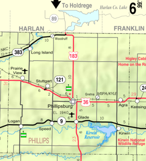
Incorporated cities
Name and population (2004 estimate):- PhillipsburgPhillipsburg, KansasPhillipsburg is a city in and the county seat of Phillips County, Kansas, United States. As of the 2010 census, the city population was 2,581.-19th century:...
, 2,473 (county seat) - LoganLogan, KansasLogan is a city in Phillips County, Kansas, United States. As of the 2010 census, the city population was 589.-Geography:Logan is located at . According to the United States Census Bureau, the city has a total area of , all of it land.-Demographics:As of the census of 2000, there were 603...
, 555 - AgraAgra, KansasAgra is a city in Phillips County, Kansas, United States. As of the 2010 census, the city population was 267.-Geography:Agra is located at . According to the United States Census Bureau, the city has a total area of , all of it land....
, 283 - KirwinKirwin, KansasKirwin is a city in Phillips County, Kansas, United States. As of the 2010 census, the city population was 171.-Geography:Kirwin is located at...
, 217 - Long IslandLong Island, KansasLong Island is a city in Phillips County, Kansas, United States. As of the 2010 census, the city population was 134.-Geography:Long Island is located at...
, 146 - Prairie ViewPrairie View, KansasPrairie View is a city in Phillips County, Kansas, United States. As of the 2010 census, the city population was 134.-Geography:Prairie View is located at...
, 133 - GladeGlade, KansasGlade is a city in Phillips County, Kansas, United States. As of the 2010 census, the city population was 96.-Geography:Glade is located at . According to the United States Census Bureau, the city has a total area of , all of it land.-Demographics:As of the census of 2000, there were 114 people,...
, 108 - SpeedSpeed, KansasSpeed is a city in Phillips County, Kansas, United States. As of the 2010 census, the city population was 37.-History:In 2008, the Hot Wheels 40th Anniversary Cross-Country Road Trip held a special event in Speed. It was only one of six stops in the USA....
, 42
Townships
Phillips County is divided into twenty-five townshipsCivil township
A civil township is a widely used unit of local government in the United States, subordinate to, and geographic divisions of, a county. Specific responsibilities and the degree of autonomy vary based on each state. Civil townships are distinct from survey townships, but in states that have both,...
. The city of Phillipsburg
Phillipsburg, Kansas
Phillipsburg is a city in and the county seat of Phillips County, Kansas, United States. As of the 2010 census, the city population was 2,581.-19th century:...
is considered governmentally independent and is excluded from the census figures for the townships. In the following table, the population center is the largest city (or cities) included in that township's population total, if it is of a significant size.
| Township | FIPS | Population center |
Population | Population density /km² (/sq mi) |
Land area km² (sq mi) | Water area km² (sq mi) | Water % | Geographic coordinates |
|---|---|---|---|---|---|---|---|---|
| Arcade | 02150 | 96 | 1 (3) | 92 (36) | 0 (0) | 0.03% | 39°46′30"N 99°13′40"W | |
| Beaver | 05100 | 54 | 1 (2) | 93 (36) | 0 (0) | 0.05% | 39°47′22"N 99°33′43"W | |
| Belmont | 05700 | 113 | 1 (3) | 93 (36) | 0 (0) | 0 % | 39°41′26"N 99°27′13"W | |
| Bow Creek | 08075 | 44 | 0 (1) | 92 (35) | 1 (1) | 1.49% | 39°36′15"N 99°13′31"W | |
| Crystal | 16550 | 59 | 1 (2) | 92 (36) | 0 (0) | 0.19% | 39°51′55"N 99°6′35"W | |
| Dayton | 17100 | 53 | 1 (1) | 92 (36) | 0 (0) | 0.10% | 39°53′27"N 99°27′15"W | |
| Deer Creek | 17200 | 67 | 1 (2) | 88 (34) | 5 (2) | 4.87% | 39°41′2"N 99°13′54"W | |
| Freedom | 24650 | 85 | 1 (2) | 92 (36) | 0 (0) | 0.10% | 39°52′18"N 99°21′40"W | |
| Glenwood | 26650 | 42 | 0 (1) | 92 (36) | 0 (0) | 0.21% | 39°57′38"N 99°14′25"W | |
| Granite | 27450 | 21 | 0 (1) | 92 (36) | 0 (0) | 0.14% | 39°58′6"N 99°28′11"W | |
| Greenwood | 28775 | 45 | 0 (1) | 92 (36) | 0 (0) | 0.05% | 39°51′51"N 99°14′24"W | |
| Kirwin | 37300 | 307 | 4 (9) | 87 (33) | 6 (2) | 6.89% | 39°40′51"N 99°7′24"W | |
| Logan | 42125 | 666 | 7 (19) | 93 (36) | 0 (0) | 0.03% | 39°40′3"N 99°34′11"W | |
| Long Island | 42625 | 251 | 3 (7) | 91 (35) | 0 (0) | 0.12% | 39°56′35"N 99°33′16"W | |
| Mound | 48725 | 129 | 1 (4) | 93 (36) | 0 (0) | 0 % | 39°47′13"N 99°27′7"W | |
| Phillipsburg | 55700 | 257 | 3 (7) | 89 (34) | 0 (0) | 0.01% | 39°46′15"N 99°20′28"W | |
| Plainview | 56125 | 23 | 0 (1) | 93 (36) | 0 (0) | 0.01% | 39°35′21"N 99°27′1"W | |
| Plum | 56775 | 447 | 5 (12) | 93 (36) | 0 (0) | 0.27% | 39°46′3"N 99°7′6"W | |
| Prairie View | 57550 | 220 | 2 (6) | 92 (36) | 0 (0) | 0.13% | 39°51′0"N 99°34′38"W | |
| Rushville | 61800 | 23 | 0 (1) | 93 (36) | 0 (0) | 0 % | 39°36′40"N 99°21′35"W | |
| Solomon | 66350 | 226 | 2 (6) | 92 (36) | 0 (0) | 0.05% | 39°41′27"N 99°20′12"W | |
| Sumner | 69175 | 43 | 0 (1) | 92 (35) | 0 (0) | 0.18% | 39°57′6"N 99°6′50"W | |
| Towanda | 71175 | 26 | 0 (1) | 93 (36) | 0 (0) | 0.20% | 39°36′13"N 99°33′43"W | |
| Valley | 73025 | 22 | 0 (1) | 85 (33) | 8 (3) | 8.70% | 39°36′58"N 99°8′3"W | |
| Walnut | 75075 | 14 | 0 (0) | 93 (36) | 0 (0) | 0.09% | 39°57′33"N 99°20′47"W |
Education
Unified school districts
- Thunder Ridge USD 110 (Consolidation of Agra-Eastern Heights and Kensington-West Smith County)
- Phillipsburg USD 325
- Logan USD 326
See also
- National Register of Historic Places listings in Phillips County, KansasNational Register of Historic Places listings in Phillips County, KansasThis is a list of the National Register of Historic Places listings in Phillips County, Kansas.This is intended to be a complete list of the properties and districts on the National Register of Historic Places in Phillips County, Kansas, United States...
Further reading
- History of the State of Kansas; William G. Cutler; A.T. Andreas Publisher; 1883. (Online HTML eBook)
- Kansas : A Cyclopedia of State History, Embracing Events, Institutions, Industries, Counties, Cities, Towns, Prominent Persons, Etc; 3 Volumes; Frank W. Blackmar; Standard Publishing Co; 944 / 955 / 824 pages; 1912. (Volume1 - Download 54MB PDF eBook),(Volume2 - Download 53MB PDF eBook), (Volume3 - Download 33MB PDF eBook)
External links
Official websitesGeneral county information
County Level Data
Maps
- Phillips County Map, KDOT
- Kansas Highway Map, KDOT
- Kansas Railroad Map, KDOT
- Kansas School District Boundary Map, KSDE