
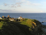
Peveril Point
Encyclopedia

Promontory
Promontory may refer to:*Promontory, a prominent mass of land which overlooks lower lying land or a body of water*Promontory, Utah, the location where the United States first Transcontinental Railroad was completed...
forming the easternmost part of the Isle of Purbeck
Isle of Purbeck
The Isle of Purbeck, not a true island but a peninsula, is in the county of Dorset, England. It is bordered by the English Channel to the south and east, where steep cliffs fall to the sea; and by the marshy lands of the River Frome and Poole Harbour to the north. Its western boundary is less well...
in Dorset
Dorset
Dorset , is a county in South West England on the English Channel coast. The county town is Dorchester which is situated in the south. The Hampshire towns of Bournemouth and Christchurch joined the county with the reorganisation of local government in 1974...
, England
England
England is a country that is part of the United Kingdom. It shares land borders with Scotland to the north and Wales to the west; the Irish Sea is to the north west, the Celtic Sea to the south west, with the North Sea to the east and the English Channel to the south separating it from continental...
, and is part of the town of Swanage
Swanage
Swanage is a coastal town and civil parish in the south east of Dorset, England. It is situated at the eastern end of the Isle of Purbeck, approximately 10 km south of Poole and 40 km east of Dorchester. The parish has a population of 10,124 . Nearby are Ballard Down and Old Harry Rocks,...
.
It is located at 50°36.43′N 01°56.69′W OS Grid Ref: SZ 041 787.
On top is a coastguard hut. The point contains underground tunnels connecting disused gun emplacements which defended the entrance to Southampton Water from the west of the Isle of Wight
Isle of Wight
The Isle of Wight is a county and the largest island of England, located in the English Channel, on average about 2–4 miles off the south coast of the county of Hampshire, separated from the mainland by a strait called the Solent...
during World War II
World War II
World War II, or the Second World War , was a global conflict lasting from 1939 to 1945, involving most of the world's nations—including all of the great powers—eventually forming two opposing military alliances: the Allies and the Axis...
.
The point is also home to the Swanage
Swanage
Swanage is a coastal town and civil parish in the south east of Dorset, England. It is situated at the eastern end of the Isle of Purbeck, approximately 10 km south of Poole and 40 km east of Dorchester. The parish has a population of 10,124 . Nearby are Ballard Down and Old Harry Rocks,...
lifeboat
Lifeboat (rescue)
A rescue lifeboat is a boat rescue craft which is used to attend a vessel in distress, or its survivors, to rescue crewmen and passengers. It can be hand pulled, sail powered or powered by an engine...
organisation.