

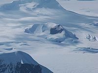
Perperek Knoll
Encyclopedia
Vidin Heights
Vidin Heights are predominantly ice-covered heights rising to 604 m on Varna Peninsula, eastern Livingston Island in the South Shetland Islands, Antarctica. The feature is approximately 8 km long from the north end of Leslie Gap east-northeastwards to Inott Point and 9.6 km...
on Varna Peninsula
Varna Peninsula
Varna Peninsula is a roughly rectangular predominantly ice-covered peninsula forming the northeast extremity of Livingston Island in the South Shetland Islands, Antarctica...
, Livingston Island in the South Shetland Islands
South Shetland Islands
The South Shetland Islands are a group of Antarctic islands, lying about north of the Antarctic Peninsula, with a total area of . By the Antarctic Treaty of 1959, the Islands' sovereignty is neither recognized nor disputed by the signatories and they are free for use by any signatory for...
, Antarctica. Partly ice-free southeast slopes. Surmounting Kaliakra Glacier
Kaliakra Glacier
Kaliakra Glacier is a glacier in northeastern Livingston Island, Antarctica extending 7 km in east-west direction and 8 km in north-south direction...
to the west and south. The peak is named after the settlement of Perperek in the Rhodope Mountains
Rhodope Mountains
The Rhodopes are a mountain range in Southeastern Europe, with over 83% of its area in southern Bulgaria and the remainder in Greece. Its highest peak, Golyam Perelik , is the seventh highest Bulgarian mountain...
hosting the remains of the Thracian
Thrace
Thrace is a historical and geographic area in southeast Europe. As a geographical concept, Thrace designates a region bounded by the Balkan Mountains on the north, Rhodope Mountains and the Aegean Sea on the south, and by the Black Sea and the Sea of Marmara on the east...
holy town of Perperikon
Perperikon
The ancient Thracian city of Perperikon is located in the Eastern Rhodopes, 15 km northeast of the present-day town of Kardzhali, Bulgaria, on a 470 m high rocky hill, which is thought to have been a sacred place. The village of Gorna Krepost is located at the foot of the hill and the...
.
Perperek official web site:www.perperek.com
Location
The knoll is located at 62°32′57"S 60°07′41"W which is 5.77 km north of Sliven PeakSliven Peak
Sliven Peak rises to 530 m in the east extremity of Melnik Ridge, Livingston Island in the South Shetland Islands, Antarctica...
, 4.51 km northeast of Leslie Hill
Leslie Hill, Livingston Island
Leslie Hill is a hill lying northward of Bowles Ridge and south of Vidin Heights in the eastern part of Livingston Island in the South Shetland Islands, Antarctica...
and 2.41 km southeast of Miziya Peak
Miziya Peak
Miziya Peak is the 604 m summit of Vidin Heights on Varna Peninsula, eastern Livingston Island in the South Shetland Islands, Antarctica...
(Bulgarian topographic survey Tangra 2004/05
Tangra 2004/05
The Tangra 2004/05 Expedition was commissioned by the Antarctic Place-names Commission at the Ministry of Foreign Affairs of Bulgaria, managed by the Manfred Wörner Foundation, and supported by the Bulgarian Antarctic Institute, the Institute of Mathematics and Informatics at the Bulgarian Academy...
, and mapping in 2005 and 2009).
Maps
- L.L. Ivanov et al. Antarctica: Livingston Island and Greenwich Island, South Shetland Islands (from English Strait to Morton Strait, with illustrations and ice-cover distribution). Scale 1:100000 topographic map. Sofia: Antarctic Place-names Commission of Bulgaria, 2005.
- L.L. Ivanov. Antarctica: Livingston Island and Greenwich, Robert, Snow and Smith Islands. Scale 1:120000 topographic map. Troyan: Manfred Wörner Foundation, 2009. ISBN 978-954-92032-6-4