
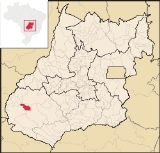
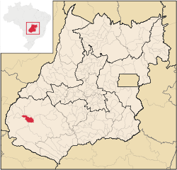
Perolândia
Encyclopedia
| Perolândia | |
|---|---|
| State | Goiás Goiás Goiás is a state of Brazil, located in the central part of the country. The name Goiás comes from the name of an indigenous community... |
| Area: | 1,029.6 km² |
| Population: | 2,748(IBGE 2007) |
| Elevation: | 889 |
| Postcode (CEP): | 75823-000 |
| IBGE statistical microregion: | 018 Sudoeste de Goiás |
| Became a city: | n/a |
| Distance to Goiânia Goiânia -Climate:The city has a tropical wet and dry climate with an average temperature of . There's a wet season, from October to April, and a dry one, from May to September. Annual rainfall is around 1,520 mm.... : |
413 km. |
| Website: | n/a |
Town
A town is a human settlement larger than a village but smaller than a city. The size a settlement must be in order to be called a "town" varies considerably in different parts of the world, so that, for example, many American "small towns" seem to British people to be no more than villages, while...
and municipality
Municipality
A municipality is essentially an urban administrative division having corporate status and usually powers of self-government. It can also be used to mean the governing body of a municipality. A municipality is a general-purpose administrative subdivision, as opposed to a special-purpose district...
in southwestern Goiás
Goiás
Goiás is a state of Brazil, located in the central part of the country. The name Goiás comes from the name of an indigenous community...
state, Brazil
Brazil
Brazil , officially the Federative Republic of Brazil , is the largest country in South America. It is the world's fifth largest country, both by geographical area and by population with over 192 million people...
. It is a large producer of soybeans.
Location and distances
Perolândia is located in the Sudoeste de Goiás Microregion north of the Rio Claro. There are paved road connections with JataíJataí
Jataí is a municipality in southern Goiás state, Brazil. Its population was 88,048 in a total area of 7,174.2 km². Jataí is a major producer of agricultural products, including soybeans, rice, and corn. It has the largest herd of cattle in the state and is a large producer of poultry and...
, which lies to the southeast.
The distance to the state capital, Goiânia
Goiânia
-Climate:The city has a tropical wet and dry climate with an average temperature of . There's a wet season, from October to April, and a dry one, from May to September. Annual rainfall is around 1,520 mm....
is 413 km. Highway connections are made by BR-060 / Abadia de Goiás
Abadia de Goiás
Abadia de Goiás is a small town and municipality in central Goiás state, Brazil, located on the western edge of the Goiânia metropolitan area.-Geographical Data:The distance to Goiânia is 27 km...
/ Guapó
Guapó
Guapó is a small town and municipality in central Goiás state, Brazil. The population was 13,586 and the total area of the municipality was 517.0 km² .Guapó is part of the Goiânia Microregion...
/ Indiara
Indiara
Indiara is a small city and municipality in central-south Goiás state, Brazil. Indiara is a large producer of soybeans and cotton.-Location:Indiara is located in the Vale do Rio dos Bois and has municipal boundaries with:*north: Palmeiras de Goiás...
/ Rio Verde
Rio Verde, Goiás
Rio Verde is a city and municipality in the Brazilian state of Goiás. It is a fast-growing center and is the largest producer of grains in the state.-Location:...
/ Jataí
Jataí
Jataí is a municipality in southern Goiás state, Brazil. Its population was 88,048 in a total area of 7,174.2 km². Jataí is a major producer of agricultural products, including soybeans, rice, and corn. It has the largest herd of cattle in the state and is a large producer of poultry and...
/ GO-050 / BR-364 / GO-516. Sepin
Municipal boundaries are with:
- north and west: MineirosMineirosMineiros is a city in the southwest of the state of Goiás, Brazil. Mineiros is the westernmost city in Goiás and a great producer of cattle, soybeans, and corn....
and CaiapôniaCaiapôniaCaiapônia is a small town and municipality in south-central Goiás state, Brazil. It has the third largest cattle herd in the state and is a major producer of grains. The town is also known as Torres Do Rio Bonito or just Rio Bonito.-Geography:... - south and east: JataíJataíJataí is a municipality in southern Goiás state, Brazil. Its population was 88,048 in a total area of 7,174.2 km². Jataí is a major producer of agricultural products, including soybeans, rice, and corn. It has the largest herd of cattle in the state and is a large producer of poultry and...
Political information
- Mayor: Nélson Américo da Costa (2005)
- City council: 9
- Eligible voters: 2,473 (April 2007)
Demographic information
- Population density: 2.67 inhab/km² (2007)
- Urban population: 1,778 >(2007)
- Rural population: 970 (2007)
- Population growth: -0.22% for 2000/2007
Economic information
The economy is based on agriculture, cattle raising, services, public administration, and small transformation industries.- Industrial units: 3 (2007)
- Commercial units: 40 (2007)
- Bank agencies: none
- Cattle herd: 27,000 head (2006)
- Dairy cows: 3,500 (2006)
- Main crops (2006): cotton (2,496 hectares), rice (900 hectares), bananas, coffee, beans, manioc, corn (5,800 hectares), sorghum (6,000 hectares), and soybeans (38,500 hectares). In 2006 there were 254 agricultural units with an area of 52,000 hectares, of which 12,000 hectares were farmland, 27,000 hectares were pasture, and 12,000 hectares were woodland. Around 800 workers were considered farm labor.
Education (2006)
- Schools: 4
- Students: 997
- Middle school enrollment: 117 students
- Higher education: none
- Adult literacy rate: 85.4% (2000) (national average was 86.4%)
Health (2007)
- Hospitals: 0
- Hospital beds: 0
- Ambulatory clinics: 1
- Infant mortality rate: 28.66 (2000) (national average was 33.0)
Ranking on the Municipal Human Development Index
Human Development Index
The Human Development Index is a composite statistic used to rank countries by level of "human development" and separate "very high human development", "high human development", "medium human development", and "low human development" countries...
- Life Expectancy: 67.2
- Adult Literacy Rate: .83
- School Attendance Rate: .78
- Monthly Per Capita Income: 211.00 Reais
- MHDI: 0.730
- Ranking in the state: 145 out of 242 municipalities
- National ranking: 2423 out of 5,507 municipalities
Data are from 2000
For the complete list see Frigoletto.com