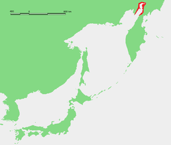
Penzhinskaya Bay
Encyclopedia

Russia
Russia or , officially known as both Russia and the Russian Federation , is a country in northern Eurasia. It is a federal semi-presidential republic, comprising 83 federal subjects...
.
Penzhina Bay is an upper right arm of Shelikhov Bay
Shelikhov Bay
The Shelikhov Gulf is a large gulf off the northwestern coast of Kamchatka, Russia. It is located in the NE corner of the Sea of Okhotsk and it branches into two main arms, the Gizhigin Bay on the west and the Penzhin Bay on the east...
in the NE corner of the Sea of Okhotsk
Sea of Okhotsk
The Sea of Okhotsk is a marginal sea of the western Pacific Ocean, lying between the Kamchatka Peninsula on the east, the Kuril Islands on the southeast, the island of Hokkaidō to the far south, the island of Sakhalin along the west, and a long stretch of eastern Siberian coast along the west and...
. It is bounded on the east by the Kamchatka Peninsula
Kamchatka Peninsula
The Kamchatka Peninsula is a peninsula in the Russian Far East, with an area of . It lies between the Pacific Ocean to the east and the Sea of Okhotsk to the west...
and on the west by the Taygonos Peninsula which separates it from Gizhigin Bay
Gizhigin Bay
Gizhigin Bay or Gyzhigin Bay is a wide bay northwest of Kamchatka, Russia. It is an upper left arm of Shelikhov Bay in the NE corner of the Sea of Okhotsk. The east side is the Tygonos Peninsula which separates it from the long and narrow Penzhin Bay. It is about 260 by 148km, has a maximum depth...
. It is about 300 km long and 65 km wide. Near the middle two peninsulas narrow it to 30 km. It freezes from October to May. It has the highest tides of any bay on the Pacific Ocean (9 meters, 12.9m maximum, versus 17 meters in the Bay of Fundy
Bay of Fundy
The Bay of Fundy is a bay on the Atlantic coast of North America, on the northeast end of the Gulf of Maine between the Canadian provinces of New Brunswick and Nova Scotia, with a small portion touching the U.S. state of Maine...
). Its basin is very thinly populated.
The Penzhina River flows into the head of the bay. It is 713 km long and flows east, then south, then southwest to reach the bay. The town of Penzhina was on the middle Penzhina and was visited by George Kennan
George Kennan (explorer)
George Kennan was an American explorer noted for his travels in the Kamchatka and Caucasus regions of the Russian Empire. He was a cousin twice removed of diplomat and historian George F. Kennan, with whom he shared his birthday....
in 1866. The major tributary of the Penzhina is the Aklan, Oklan or Khayakha River which flows southeast and joins the Penzhina about 50 miles from its mouth. In 1669 the Russians built the ostrog
Ostrog (fortress)
Ostrog was a Russian term for a small fort, typically wooden and often non-permanently manned. Ostrogs were encircled by 4-6 metres high palisade walls made from sharpened trunks. The name derives from the Russian word строгать , "to shave the wood". Ostrogs were smaller and exclusively military...
of Aklansk, which was used to subdue the local Koryaks
Koryaks
Koryaks are an indigenous people of Kamchatka Krai in the Russian Far East, who inhabit the coastlands of the Bering Sea to the south of the Anadyr basin and the country to the immediate north of the Kamchatka Peninsula, the southernmost limit of their range being Tigilsk. They are akin to the...
and was an important base on the route south from Anadyrsk
Anadyrsk
thumb|Anadyrsk was on the east-west part of the Anadyr River at the point where it swings northAnadyrsk was an important Russian ostrog in far northeastern Siberia from 1649 to 1764...
to the Kamchatka peninsula
Kamchatka Peninsula
The Kamchatka Peninsula is a peninsula in the Russian Far East, with an area of . It lies between the Pacific Ocean to the east and the Sea of Okhotsk to the west...
before the sea route from Okhotsk
Okhotsk
Okhotsk is an urban locality and a seaport at the mouth of the Okhota River on the Sea of Okhotsk, in Okhotsky District, Khabarovsk Krai, Russia. Population: 4,470 ;...
opened up. It was attacked by the Koryaks several times and later abandoned.

