
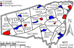
Penns Creek, Pennsylvania
Encyclopedia
Census-designated place
A census-designated place is a concentration of population identified by the United States Census Bureau for statistical purposes. CDPs are delineated for each decennial census as the statistical counterparts of incorporated places such as cities, towns and villages...
(CDP) in Snyder County
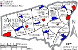
Snyder County, Pennsylvania
Snyder County is a county located in the U.S. state of Pennsylvania. As of 2010, the population was 39,702. Snyder County was formed in 1855 from parts of Union County...
, Pennsylvania
Pennsylvania
The Commonwealth of Pennsylvania is a U.S. state that is located in the Northeastern and Mid-Atlantic regions of the United States. The state borders Delaware and Maryland to the south, West Virginia to the southwest, Ohio to the west, New York and Ontario, Canada, to the north, and New Jersey to...
.
Its ZIP code
ZIP Code
ZIP codes are a system of postal codes used by the United States Postal Service since 1963. The term ZIP, an acronym for Zone Improvement Plan, is properly written in capital letters and was chosen to suggest that the mail travels more efficiently, and therefore more quickly, when senders use the...
is 17862.
Geography
Penns Creek is located at 40°51′38"N 77°3′30"W (40.860555, -77.058207), bordered on the north by its namesake creek, Penns CreekPenns Creek
Penns Creek is a tributary of the Susquehanna River in central Pennsylvania in the United States. Originally named "John Penn's Creek" after William Penn's younger brother, it was renamed Penns Creek in 1802 by an Act of Assembly...
. It lies along PA route 104
Pennsylvania Route 104
Pennsylvania Route 104 is a long state highway located in Perry, Juniata, Snyder, and Union counties in Pennsylvania. The southern terminus is at US 11/US 15 between McKees Half Falls and Liverpool...
between Middleburg
Middleburg, Pennsylvania
Middleburg is a borough in Snyder County, Pennsylvania, United States. The population was 1,382 at the 2000 census. It is the county seat of Snyder County.-History:...
to the south and Mifflinburg
Mifflinburg, Pennsylvania
-Education:There are no colleges or universities in Mifflinburg.The Mifflinburg Area School District has a number of its schools located in the borough. It has the high school , the middle school and the Mifflinburg Area Intermediate School which opened for the 2006 school year...
to the north.
According to the United States Census Bureau
United States Census Bureau
The United States Census Bureau is the government agency that is responsible for the United States Census. It also gathers other national demographic and economic data...
, the CDP has a total area of 1.1 square miles (2.8 km²), all of it land.
Demographics
As of the censusCensus
A census is the procedure of systematically acquiring and recording information about the members of a given population. It is a regularly occurring and official count of a particular population. The term is used mostly in connection with national population and housing censuses; other common...
of 2000, there were 668 people, 221 households, and 165 families residing in the CDP. The population density
Population density
Population density is a measurement of population per unit area or unit volume. It is frequently applied to living organisms, and particularly to humans...
was 580.4 people per square mile (224.3/km²). There were 231 housing units at an average density of 200.7/sq mi (77.6/km²). The racial makeup of the CDP was 97.31% White, 1.20% African American, 0.60% Native American, 0.15% Pacific Islander, 0.45% from other races
Race (United States Census)
Race and ethnicity in the United States Census, as defined by the Federal Office of Management and Budget and the United States Census Bureau, are self-identification data items in which residents choose the race or races with which they most closely identify, and indicate whether or not they are...
, and 0.30% from two or more races. Hispanic or Latino of any race were 1.05% of the population.
There were 221 households out of which 38.0% had children under the age of 18 living with them, 60.2% were married couples
Marriage
Marriage is a social union or legal contract between people that creates kinship. It is an institution in which interpersonal relationships, usually intimate and sexual, are acknowledged in a variety of ways, depending on the culture or subculture in which it is found...
living together, 10.4% had a female householder with no husband present, and 25.3% were non-families. 22.6% of all households were made up of individuals and 7.7% had someone living alone who was 65 years of age or older. The average household size was 2.76 and the average family size was 3.24.
In the CDP the population was spread out with 27.5% under the age of 18, 17.1% from 18 to 24, 25.9% from 25 to 44, 21.1% from 45 to 64, and 8.4% who were 65 years of age or older. The median age was 31 years. For every 100 females there were 89.8 males. For every 100 females age 18 and over, there were 87.6 males.
The median income for a household in the CDP was $28,500, and the median income for a family was $38,036. Males had a median income of $26,667 versus $18,971 for females. The per capita income
Per capita income
Per capita income or income per person is a measure of mean income within an economic aggregate, such as a country or city. It is calculated by taking a measure of all sources of income in the aggregate and dividing it by the total population...
for the CDP was $11,029. About 14.1% of families and 16.3% of the population were below the poverty line, including 23.5% of those under age 18 and 6.3% of those age 65 or over.
History
The community was founded in 1806 by Lt. Col. George Weirick (1773–1838), a veteran of the War of 1812, and son or Capt. Wilhelm Weirick (1731–1807), a veteran of the American Revolution, and grandson of German immigrant Johann Georg Weyrich (1702–1751). The village was originally called Weirickstown. Weirick served as county commissioner in 1824, justice of the peace in 1813, and as a member of the General Assembly of Pennsylvania (1832–1833). He is buried in the Salem Church Cemetery in Snyder County. The village name was later changed to Centreville, and then changed again due to a conflict with another village of the same name in Crawford County, PA. The nearby creek's name was adopted sometime after 1842. It was originally part of Northumberland CountyNorthumberland County, Pennsylvania
There were 38,835 households out of which 27.30% had children under the age of 18 living with them, 52.40% were married couples living together, 9.60% had a female householder with no husband present, and 34.10% were non-families. 30.20% of all households were made up of individuals and 15.50% had...
, then Union
Union County, Pennsylvania
-Demographics:As of the census of 2000, there were 41,624 people, 13,178 households, and 9,211 families residing in the county. The population density was 131 people per square mile . There were 14,684 housing units at an average density of 46 per square mile...
. On March 2, 1855, Penns Creek became part of Snyder County. Snyder County was named for Governor Simon Snyder
Simon Snyder
Simon Snyder was the third Governor of the Commonwealth of Pennsylvania from 1808 to 1817. A Jeffersonian Democrat, he served three terms as speaker of the Pennsylvania House of Representatives before becoming governor...
of Selinsgrove
Selinsgrove, Pennsylvania
Selinsgrove is a borough in Snyder County, Pennsylvania, United States. It was founded in 1787 by Captain Anthony Selin, who fought with Washington in the Revolutionary War....
. Buried in the old Sharon Lutheran Churchyard in Selinsgrove, Snyder was very popular and was the only governor of Pennsylvania to serve three terms
Environmental issues
Ongoing pollution and soil erosion in the region continue to degrade the water quality and the environment locally as well as regionally. Farming, wastewater treatment facilities and industrial spills are cited as contributing factors to loss of water quality. It also contributes to the pollution of the Chesapeake BayChesapeake Bay
The Chesapeake Bay is the largest estuary in the United States. It lies off the Atlantic Ocean, surrounded by Maryland and Virginia. The Chesapeake Bay's drainage basin covers in the District of Columbia and parts of six states: New York, Pennsylvania, Delaware, Maryland, Virginia, and West...
. Controlling the wastewater discharges alone is expected to cost local taxpayers billions of dollars.
The Lower Penns Creek Watershed Association’s central purpose is to protect, conserve, and improve the Lower Penns Creek watershed by promoting the wise stewardship of the land and aquatic resources. The organization is open to all citizens. The organization has sponsored a main stream assessment The Lower Penns Creek watershed is approximately 163 square miles (422.2 km²) within Snyder and Union Counties. It drains into the Susquehanna River on the northern border of the community of Selinsgrove, Pennsylvania. It is located within the Lower Susquehanna subbasin. LPCWA’s efforts contribute to the success of the missions of the Susquehanna Greenway Partnership and the Susquehanna River Basin Commission. The Snyder County Conservation District and the Union County Conservation District both have watershed specialists that participate in LPCWA.