
Pathfinder Dam
Encyclopedia
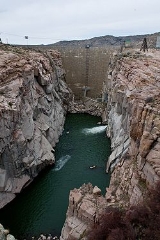
Pathfinder Dam is a cyclopean masonry
dam, located on the North Platte River
, approximately 47 miles (75.6 km) southwest of Casper, Wyoming
. It was originally constructed between 1905 and 1909 as part of the North Platte Project
and has been modified several times since then. It is included on the National Register of Historic Places
. Construction of the dam created Pathfinder Reservoir
which provides water storage for 226000 acres (914.6 km²) of irrigation in Wyoming and Nebraska. The dam is named for General John Charles Fremont, who had explored the area in 1842 and was nicknamed the "Pathfinder of the West."
, its contemporary, Pathfinder Dam was intended to irrigate semi-arid lands in Wyoming. Buffalo Bill Dam, however, is of concrete construction, owing to its location within 7 miles (11.3 km) from the railroad, while Pathfinder Dam is about 45 miles (72.4 km) from the nearest railroad. Freight took at least three days to cover the distance, and once took 76 days. Transportation of cement in barrels was not feasible by horse-drawn wagon, so the dam was built of quarried stone. The dam was faced with stones between 24 inches (61 cm) and 36 inches (91.4 cm) thick, laid in a 2 inches (5.1 cm) thick mortar bed. Between these facings was a core of irregularly-shaped granite blocks of up to ten tons in weight, bedded in mortar and quarry tailings. The diversion tunnel was adapted to become the dam's outlet works. Construction costs were $2.5 million in 1909. An auxiliary dike, 38 feet (11.6 m) high, extends to the south of the dam. It is an earthfill structure with a concrete corewall. A natural channel was enlarged and straightened to form an uncontrolled spillway on the north side of the dam.
The original diversion tunnel became the north outlet works, abandoned and sealed in 1958 with bulkheads. From 1958 the tunnel was modified to feed the power outlet works, an 18 feet (5.5 m) tunnel extending 3 miles (4.8 km) to the Fremont Canyon Powerplant at the upper end of Alcova Reservoir. The Fremont Canyon Powerplant has a capacity of 66.8 MW with two turbines., upgraded from 48 MW between 1986 and 1990. A low-flow outlet was completed at the dam in 1997 to allow water flow in the four river miles between the dam and the powerplant.
at a narrow point known as Devil's Gate. A more ambitious plan was proposed in 1903 by the newly-established Bureau of Reclamation to dam a site below the confluence of the Sweetwater and the North Platte. The dam's design was carried out by George Y. Wisner of the Reclamation Service, with consulting engineer Edgar T. Wheeler. Exploratory drilling was started in 1903, and a contract for a 480 feet (146.3 m) long diversion tunnel was let in 1905. Bidding for the dam construction contract was plagued with delays; the initial contractor withdrew, citing bidding errors. Eventually, the construction contract was awarded to the Geddis and Seerie Stone Company of Denver, for an initial sum of $482,000, later to rise to $626,523.52. Difficulties with the construction of an upstream cofferdam, created by the contractor's improper blasting of loose rock from the canyon walls, led to the first delays. Foundation work on the dam started in January 1906, with the foundation set only 10 feet (3 m) deep.
After delays caused by flood waters, the dam was completed on June 14, 1909. However, unusual summer rains filled the reservoir, overtaxed the spillways and threatened to overtop the location of the future auxiliary earthfill dike, possibly allowing the river to cut a new, lower channel and potentially leaving the damsite dry. Explosive charges were placed in the crest of the main dam, to be used if the overflow occurred, thus keeping the lowest point at the dam. The dike held and the charges were not needed, but did have to be removed by explosives experts in 1949. An auxiliary dike was built at the location in 1910 to develop the reservoir's full capacity. The potential overtopping gave rise to sensational stories in Denver newspapers and caused annual nervousness in Casper
downstream for a number of years thereafter. The Fremont Canyon Powerplant was built between 1958 and 1961, part of the Glendo Unit of the Pick–Sloan Missouri Basin Project.
The reservoir has suffered from siltation, leading to a 1995 proposal to add between 2 feet (61 cm) and 2.5 feet (76.2 cm) to the top of the dam to add storage capacity.
The Pathfinder Interpretive Center is a small museum located in the former damkeeper's residence near the dam. Pathfinder National Wildlife Refuge
encompasses portions of the reservoir. There are five campgrounds and a marina on the reservoir. A suspension footbridge crosses the river below the dam. Pathfinder Dam was placed on the National Register of Historic Places
on August 12, 1971.
Cyclopean masonry
Cyclopean masonry is a type of stonework found in Mycenaean architecture, built with huge limestone boulders, roughly fitted together with minimal clearance between adjacent stones and no use of mortar...
dam, located on the North Platte River
North Platte River
The North Platte River is a major tributary of the Platte River and is approximately long counting its many curves, It travels about distance. Its course lies in the U.S...
, approximately 47 miles (75.6 km) southwest of Casper, Wyoming
Casper, Wyoming
Casper is the county seat of Natrona County, Wyoming, United States.. Casper is the second-largest city in Wyoming , according to the 2010 census, with a population of 55,316...
. It was originally constructed between 1905 and 1909 as part of the North Platte Project
North Platte Project
The North Platte Project is an irrigation project in the U.S. states of Wyoming and Nebraska. The project provides irrigation service to about . The primary water storage for the project is in Pathfinder Reservoir in Wyoming. Downstream, Guernsey Dam manages river flow and provides secondary...
and has been modified several times since then. It is included on the National Register of Historic Places
National Register of Historic Places
The National Register of Historic Places is the United States government's official list of districts, sites, buildings, structures, and objects deemed worthy of preservation...
. Construction of the dam created Pathfinder Reservoir
Pathfinder Reservoir
Pathfinder Reservoir is located in the U.S. state of Wyoming on the North Platte River between Casper and Rawlins. It sits 47 miles southwest of Casper, in Carbon County and Natrona County. The reservoir was created by Pathfinder Dam and has a storage capacity of . The shoreline consists of 117...
which provides water storage for 226000 acres (914.6 km²) of irrigation in Wyoming and Nebraska. The dam is named for General John Charles Fremont, who had explored the area in 1842 and was nicknamed the "Pathfinder of the West."
Description
Pathfinder Dam is composed of granite blocks, quarried from the same stone that forms the river's canyon. With Buffalo Bill DamBuffalo Bill Dam
Buffalo Bill Dam is a concrete arch-gravity dam on the Shoshone River in the U.S. state of Wyoming. The dam is named after the famous old West figure William "Buffalo Bill" Cody who founded the nearby town of Cody and who owned much of the land now covered by the reservoir formed by the dam, which...
, its contemporary, Pathfinder Dam was intended to irrigate semi-arid lands in Wyoming. Buffalo Bill Dam, however, is of concrete construction, owing to its location within 7 miles (11.3 km) from the railroad, while Pathfinder Dam is about 45 miles (72.4 km) from the nearest railroad. Freight took at least three days to cover the distance, and once took 76 days. Transportation of cement in barrels was not feasible by horse-drawn wagon, so the dam was built of quarried stone. The dam was faced with stones between 24 inches (61 cm) and 36 inches (91.4 cm) thick, laid in a 2 inches (5.1 cm) thick mortar bed. Between these facings was a core of irregularly-shaped granite blocks of up to ten tons in weight, bedded in mortar and quarry tailings. The diversion tunnel was adapted to become the dam's outlet works. Construction costs were $2.5 million in 1909. An auxiliary dike, 38 feet (11.6 m) high, extends to the south of the dam. It is an earthfill structure with a concrete corewall. A natural channel was enlarged and straightened to form an uncontrolled spillway on the north side of the dam.
The original diversion tunnel became the north outlet works, abandoned and sealed in 1958 with bulkheads. From 1958 the tunnel was modified to feed the power outlet works, an 18 feet (5.5 m) tunnel extending 3 miles (4.8 km) to the Fremont Canyon Powerplant at the upper end of Alcova Reservoir. The Fremont Canyon Powerplant has a capacity of 66.8 MW with two turbines., upgraded from 48 MW between 1986 and 1990. A low-flow outlet was completed at the dam in 1997 to allow water flow in the four river miles between the dam and the powerplant.
History
In 1902 plans were advanced to dam the Sweetwater RiverSweetwater River
Sweetwater River may refer to:*Sweetwater River , a river in San Diego County, California, USA*Sweetwater River , a river in Natrona County, Wyoming, USA...
at a narrow point known as Devil's Gate. A more ambitious plan was proposed in 1903 by the newly-established Bureau of Reclamation to dam a site below the confluence of the Sweetwater and the North Platte. The dam's design was carried out by George Y. Wisner of the Reclamation Service, with consulting engineer Edgar T. Wheeler. Exploratory drilling was started in 1903, and a contract for a 480 feet (146.3 m) long diversion tunnel was let in 1905. Bidding for the dam construction contract was plagued with delays; the initial contractor withdrew, citing bidding errors. Eventually, the construction contract was awarded to the Geddis and Seerie Stone Company of Denver, for an initial sum of $482,000, later to rise to $626,523.52. Difficulties with the construction of an upstream cofferdam, created by the contractor's improper blasting of loose rock from the canyon walls, led to the first delays. Foundation work on the dam started in January 1906, with the foundation set only 10 feet (3 m) deep.
After delays caused by flood waters, the dam was completed on June 14, 1909. However, unusual summer rains filled the reservoir, overtaxed the spillways and threatened to overtop the location of the future auxiliary earthfill dike, possibly allowing the river to cut a new, lower channel and potentially leaving the damsite dry. Explosive charges were placed in the crest of the main dam, to be used if the overflow occurred, thus keeping the lowest point at the dam. The dike held and the charges were not needed, but did have to be removed by explosives experts in 1949. An auxiliary dike was built at the location in 1910 to develop the reservoir's full capacity. The potential overtopping gave rise to sensational stories in Denver newspapers and caused annual nervousness in Casper
Casper, Wyoming
Casper is the county seat of Natrona County, Wyoming, United States.. Casper is the second-largest city in Wyoming , according to the 2010 census, with a population of 55,316...
downstream for a number of years thereafter. The Fremont Canyon Powerplant was built between 1958 and 1961, part of the Glendo Unit of the Pick–Sloan Missouri Basin Project.
The reservoir has suffered from siltation, leading to a 1995 proposal to add between 2 feet (61 cm) and 2.5 feet (76.2 cm) to the top of the dam to add storage capacity.
The Pathfinder Interpretive Center is a small museum located in the former damkeeper's residence near the dam. Pathfinder National Wildlife Refuge
Pathfinder National Wildlife Refuge
Pathfinder National Wildlife Refuge is located in the U.S. state of Wyoming and includes 16,807 acres . The refuge is managed by the U.S. Fish and Wildlife Service and the U.S. Bureau of Reclamation, both agencies within the U.S. Department of the Interior...
encompasses portions of the reservoir. There are five campgrounds and a marina on the reservoir. A suspension footbridge crosses the river below the dam. Pathfinder Dam was placed on the National Register of Historic Places
National Register of Historic Places
The National Register of Historic Places is the United States government's official list of districts, sites, buildings, structures, and objects deemed worthy of preservation...
on August 12, 1971.
See also
- Theodore Roosevelt DamTheodore Roosevelt DamTheodore Roosevelt Dam is a dam on the Salt River located northeast of Phoenix, Arizona. The dam is high and forms Theodore Roosevelt Lake as it impounds the Salt River. Originally built between 1905 and 1911, the dam was renovated and expanded in 1989-1996. The dam is named after then-President...
, a similar cyclopean masonry dam on Arizona's Salt River ProjectSalt River ProjectThe Salt River Project is the umbrella name for two separate entities: the Salt River Project Agricultural Improvement and Power District, an agency of the state of Arizona that serves as an electrical utility for the Phoenix metropolitan area, and the Salt River Valley Water Users' Association, a...
External links
- Pathfinder Dam at the Wyoming State Historic Preservation Office
- Pathfinder Dam at the Bureau of Reclamation
- North Platte Project at the Bureau of Reclamation
- Fremont Canyon Powerplant at the Bureau of Reclamation