
Panamá, Goiás
Encyclopedia
| Panamá | |
|---|---|
| State | Goiás Goiás Goiás is a state of Brazil, located in the central part of the country. The name Goiás comes from the name of an indigenous community... |
| Coordinates: | 18°07′53"S 49°17′03"W |
| Area: | 443.7 km² |
| Population: | 2,618 (IBGE 2007) |
| Elevation: | 733 m above sea level |
| Postcode (CEP): | 75580-000 |
| Became a city: | 1952 |
| Mayor: | Maria Lucimar Faustina de Abreu (2005-2009) |
| Distance to Goiânia Goiânia -Climate:The city has a tropical wet and dry climate with an average temperature of . There's a wet season, from October to April, and a dry one, from May to September. Annual rainfall is around 1,520 mm.... : |
188 km. |
| IBGE statistical microregion: | Meia Ponte Microregion Meia Ponte Microregion The Meia Ponte Microregion is a statistical region of Goiás state, Brazil created by the IBGE . It is located south of the state capital, Goiânia, and includes 21 cities with a total population of 338,147 inhabitants . The total area is 21,229.00 km² and the population density is 14.39 inhab/km²... |
| Website: | none |
Town
A town is a human settlement larger than a village but smaller than a city. The size a settlement must be in order to be called a "town" varies considerably in different parts of the world, so that, for example, many American "small towns" seem to British people to be no more than villages, while...
and municipality
Municipality
A municipality is essentially an urban administrative division having corporate status and usually powers of self-government. It can also be used to mean the governing body of a municipality. A municipality is a general-purpose administrative subdivision, as opposed to a special-purpose district...
in south Goiás
Goiás
Goiás is a state of Brazil, located in the central part of the country. The name Goiás comes from the name of an indigenous community...
state, Brazil
Brazil
Brazil , officially the Federative Republic of Brazil , is the largest country in South America. It is the world's fifth largest country, both by geographical area and by population with over 192 million people...
.
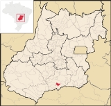
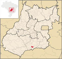
Location
Panamá is located in the Meia Ponte Microregion
Meia Ponte Microregion
The Meia Ponte Microregion is a statistical region of Goiás state, Brazil created by the IBGE . It is located south of the state capital, Goiânia, and includes 21 cities with a total population of 338,147 inhabitants . The total area is 21,229.00 km² and the population density is 14.39 inhab/km²...
and is about 25 kilometers north of the border with the state of Minas Gerais
Minas Gerais
Minas Gerais is one of the 26 states of Brazil, of which it is the second most populous, the third richest, and the fourth largest in area. Minas Gerais is the Brazilian state with the largest number of Presidents of Brazil, the current one, Dilma Rousseff, being one of them. The capital is the...
. It is a short distance west of the important BR-153 highway which links São Paulo
São Paulo
São Paulo is the largest city in Brazil, the largest city in the southern hemisphere and South America, and the world's seventh largest city by population. The metropolis is anchor to the São Paulo metropolitan area, ranked as the second-most populous metropolitan area in the Americas and among...
to Belém
Belém
Belém is a Brazilian city, the capital and largest city of state of Pará, in the country's north region. It is the entrance gate to the Amazon with a busy port, airport and bus/coach station...
. Panamá is 26 kilometers south of Goiatuba
Goiatuba
Goiatuba is a small city and municipality in south-central Goiás state, Brazil. The population was 31,225 in a total area of 2,475.10 km² . Goiatuba is a large producer of grains, especially soybeans and corn....
and 25 kilometers from Itumbiara
Itumbiara
Itumbiara is a small city and municipality in the extreme south of the state of Goiás, Brazil. The population was 100,000 in a total area of 2,461,3 km²...
. The distance to Goiânia
Goiânia
-Climate:The city has a tropical wet and dry climate with an average temperature of . There's a wet season, from October to April, and a dry one, from May to September. Annual rainfall is around 1,520 mm....
is 188 km.
Neighboring municipalities are:
- north: GoiatubaGoiatubaGoiatuba is a small city and municipality in south-central Goiás state, Brazil. The population was 31,225 in a total area of 2,475.10 km² . Goiatuba is a large producer of grains, especially soybeans and corn....
- south and west: ItumbiaraItumbiaraItumbiara is a small city and municipality in the extreme south of the state of Goiás, Brazil. The population was 100,000 in a total area of 2,461,3 km²...
- east: Bom Jesus de GoiásBom Jesus de GoiásBom Jesus de Goiás is a town and municipality in south Goiás state, Brazil. It is a large producer of soybeans.-Geographical Information:The distance to the state capital, Goiânia, is 223 km and it is linked by highways BR-452 and GO-040...
History
Panamá began with the building of a chapel by a local landowner. In 1931 it became a district of Santa Rita do Paranaíba (present-day Itumbiara
Itumbiara
Itumbiara is a small city and municipality in the extreme south of the state of Goiás, Brazil. The population was 100,000 in a total area of 2,461,3 km²...
with the name Divinópolis. In 1943 the name was changed to Panamá and Santa Rita changed to Itumbiara
Itumbiara
Itumbiara is a small city and municipality in the extreme south of the state of Goiás, Brazil. The population was 100,000 in a total area of 2,461,3 km²...
. In 1950 it was dismembered from Itumbiara. The name comes from a small river called Panamá.
Political Information
- Mayor: Maria Lucimar Faustina de Abreu (January 2005)
- City council: 9
Demographic Information
- Population density: 6.04 inhab/km² (2007)
- Urban population: 1,995 (2007)
- Rural population: 623 (2007)
- Population growth 2000-2007: -0,83%
Economic Information
The economy is based on agriculture, cattle raising, services, public administration, and small transformation industries.
- Industrial units: 2 (2007)
- Commercial units: 24 (2007)
- Cattle herd: 27,800 head (2006)
- Main crops (2006): cotton (700 hectares), rice (400 hectares), sugarcane, oranges, manioc, corn, and soybeans (5,700 hectares).
In 2006 there were 221 farmers with a planted area of 6,368 hectares. The total agricultural area was 16,567 ha.. Pasture made up 9,290 ha.
Education (2006)
- Schools: 3
- Students: 795
- Middle schools and students: 1 with 155 students
- Higher education: none
- Adult literacy rate: 81.9% (2000) (national average was 86.4%)
Health (2007)
- Hospitals: 0
- Hospital beds: 0
- Ambulatory clinics: 1
- Infant mortality rate: 23.05 (2000) (national average was 33.0)
The United Nations Human Development Index
Human Development Index
The Human Development Index is a composite statistic used to rank countries by level of "human development" and separate "very high human development", "high human development", "medium human development", and "low human development" countries...
(2000) ranked Panamá 131 out of 242 municipalities in the state of Goiás
Goiás
Goiás is a state of Brazil, located in the central part of the country. The name Goiás comes from the name of an indigenous community...
with a score of 0.733.
For the complete list see Frigoletto
See also
List of municipalities in Goiás
Sources of Data