

Palilula Belgrade
Encyclopedia
Palilula is an urban neighborhood and one of 17 municipalities which constitute the City of Belgrade
, the capital of Serbia
. It has the largest area of all municipalities of Belgrade.
in downtown Belgrade. Like majority of Belgrade's neighborhoods it has no firm boundaries and is roughly bordered by the Ruzveltova street and the municipality and neighborhood of Zvezdara
on the east, neighborhood of Hadžipopovac
in its own municipality on the north, neighborhood and municipality of Stari Grad
and Jevremovac
on the northwest (Jevremovac actually belongs to the neighborhood of Palilula, but administratively is part of Stari Grad), and the Tašmajdan and the King Alexander Boulevard on the south, bordering with the municipality of Vračar
. Several small local communities which make this area had the combined population of 14,896 in 2002.
occupied northern Serbia 1717-1739. The settlement, built as an outer suburb of Belgrade, was originally named Karlstadt and was well known for agriculture and craftsmanship of its inhabitants. In the early 19th century, Palilula becomes overwhelmingly populated by the Serbs
. In 1840 villagers of Palilula rejected the regulatory plan of Belgrade, on basis that projected new streets would be too wide, and later even tried to split from the municipality of Belgrade because of the city government's low funding for the village. However, in the late 19th century Palilula became part of the continuously built-up area of Belgrade. The neighborhood is almost entirely residential, with lots of commercial facilities being so close to the center of Belgrade.
means light a smoking pipe. One anecdote goes back to times when Belgrade and Serbia were occupied by the Ottoman Empire
and Palilula used to be the area where most crops were so Turkish rulers banned smoking due to few instances of accidental setting of crops on fire. In the late summer and early autumn when all crops have been picked up, smoking ban was lifted and locals were announcing this by calling neighbours and letting them know that pipes may be lit. Another explanation comes from period of prince Miloš Obrenović's rule who banned smoking in Belgrade so you could only smoke outside the city gates.
, which divides it in two: Šumadija
section (on the right bank) and Banat
section (on the left bank).
Šumadija section borders the municipalities of Stari Grad to the west, Vračar and Zvezdara to the south and Grocka
to the extreme southeast. It also has a river border on the Danube to the province of Vojvodina
(Municipality of Pančevo
).
Banat section has no land borders to the other Belgrade municipalities, but has a river border on the Danube to the municipalities of Zemun
and Stari Grad. Danube also makes the complete western border to the rest of the Syrmia
region in Vojvodina (municipality of Stara Pazova
), while the river Tamiš
makes the eastern border (municipalities of Pančevo and Opovo
). On the extreme north, Palilula borders the municipality of Zrenjanin
(village of Čenta
on the Karaš canal which connects the Danube and the Tamiš).
headland piking into the Danube. The prominent features in this part are the hills of Karaburma and Milićevo brdo, the spa
of Višnjička Banja and the peninsula (formerly an island) Ada Huja
.
Banat section is the extreme southwestern part of Banat region, known as Pančevački Rit
. A 400 km² (154.4 sq mi) large flat marshy floodplain
of the Danube and Tamiš, it has been drained since 1945 but still holds many features of a swamp, including slow, meandering and flooding streams (Vizelj, Mokri Sebeš
, Jojkićev Dunavac, Dunavac, etc.) and marshy bogs (Sebeš, Veliko Blato, Široka Bara
). An island of Kožara
is located on the Danube, and is projected starting point of the future much larger artificial island of Čaplja
. The spa of Ovčanska Banja
is also located here. The area close to the Danube is heavily forested.
Presidents of the municipal assembly:
. As procedure by the city statute provides that municipal assembly (in this case, of Palilula) needs to start the motion in the city assembly, after years of public agitation, the municipal assembly of Palilula agreed to do so in summer 2005, but it still didn't officially did so, so the organization for separation of Dunavski Venac announced it will go to the court.
The village of Čenta in the Vojvodina's municipality of Zrenjanin is located on the northern border of the municipality of Palilula. Now and then, a motions by the locals, not very vocal though, appear, asking for Čenta to be annexed to the City of Belgrade. Majority of population work on the territory of Belgrade and until recently, one regular bus line of Belgrade City public transportation was connecting Čenta to Belgrade.
and Čukarica
), but the growth of population, as in the rest of Belgrade, is slowing down. The major gainer of population in the municipality is still the suburb of Borča
. Population of Palilula:
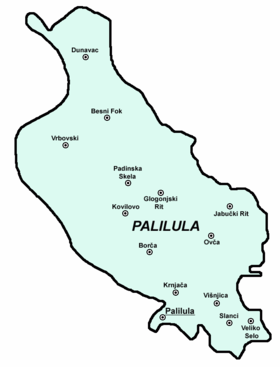 Neighborhoods of urban Palilula on the right bank of the Danube:
Neighborhoods of urban Palilula on the left bank of the Danube:
Settlements of suburban Palilula on the right bank of the Danube:
Settlements and neighborhoods of suburban Palilula on the left bank of the Danube:
Neighborhoods of Borča:
Neighborhoods of Padinska Skela:
Palilula is crisscrossed by some of the major railroads in Belgrade area: Zrenjaninski put, Pančevački put, Višnjička street, Slanački put, etc. The only Belgrade's bridge over the Danube, Pančevo Bridge
(with railway) is located in Palilula.
Intensive agrucultural production is developed in Banat section and eastern areas around Veliko Selo, producing large amounts of food (grains, fruits, vegetables, dairy products, etc.) for the population of Belgrade. Palilula has the largest agricultural area of all municipalities of Belgrade. It covers an area of 298 square kilometers, or 66,5 % of the entire municipal territory.
and the Mining and Geology Faculty. Also, the building of Radio Television of Serbia
, St. Mark's Church
, Tašmajdan Park, sports Pionir Hall
and the stadium
of the OFK Belgrade soccer team are located in the municipality.
track is located in Ada Huja. Future artificial island of Čaplja
on the Danube is projected as the modern entertainment park, with aqua parks, golf courses, etc.
, Greece
Belgrade
Belgrade is the capital and largest city of Serbia. It is located at the confluence of the Sava and Danube rivers, where the Pannonian Plain meets the Balkans. According to official results of Census 2011, the city has a population of 1,639,121. It is one of the 15 largest cities in Europe...
, the capital of Serbia
Serbia
Serbia , officially the Republic of Serbia , is a landlocked country located at the crossroads of Central and Southeast Europe, covering the southern part of the Carpathian basin and the central part of the Balkans...
. It has the largest area of all municipalities of Belgrade.
Location
Palilula is located east of TerazijeTerazije
Terazije is the central square and an urban neighborhood of Belgrade, the capital of Serbia. It is located in the Belgrade municipality of Stari Grad.- Location :...
in downtown Belgrade. Like majority of Belgrade's neighborhoods it has no firm boundaries and is roughly bordered by the Ruzveltova street and the municipality and neighborhood of Zvezdara
Zvezdara
Zvezdara is a hill, forest, urban neighborhood and one of 17 municipalities which constitute City of Belgrade, the capital of Serbia.- Location :...
on the east, neighborhood of Hadžipopovac
Hadžipopovac
Hadžipopovac is an urban neighborhood of Belgrade, the capital of Serbia. It is located in Belgrade's municipality of Palilula.Hadžipopovac is located in the central part of urban section of the municipality...
in its own municipality on the north, neighborhood and municipality of Stari Grad
Stari Grad, Belgrade
Stari Grad is an urban neighborhood and one of 17 municipalities which constitute the Belgrade, the capital of Serbia. It encompasses some of the oldest sections of urban Belgrade, thus the name...
and Jevremovac
Jevremovac
Botanical Garden Jevremovac is an urban neighborhood of Belgrade, the capital of Serbia and the city's only arboretum...
on the northwest (Jevremovac actually belongs to the neighborhood of Palilula, but administratively is part of Stari Grad), and the Tašmajdan and the King Alexander Boulevard on the south, bordering with the municipality of Vračar
Vracar
Vračar is an urban neighborhood and one of 17 municipalities which constitute the City of Belgrade. With an area of only , it is the smallest of all Belgrade's municipalities, but also the most densely populated. Vračar is one of the three municipalities that constitute the central area of the...
. Several small local communities which make this area had the combined population of 14,896 in 2002.
History
The neighborhood originates from the first half of the 18th century, when Habsburg MonarchyHabsburg Monarchy
The Habsburg Monarchy covered the territories ruled by the junior Austrian branch of the House of Habsburg , and then by the successor House of Habsburg-Lorraine , between 1526 and 1867/1918. The Imperial capital was Vienna, except from 1583 to 1611, when it was moved to Prague...
occupied northern Serbia 1717-1739. The settlement, built as an outer suburb of Belgrade, was originally named Karlstadt and was well known for agriculture and craftsmanship of its inhabitants. In the early 19th century, Palilula becomes overwhelmingly populated by the Serbs
Serbs
The Serbs are a South Slavic ethnic group of the Balkans and southern Central Europe. Serbs are located mainly in Serbia, Montenegro and Bosnia and Herzegovina, and form a sizable minority in Croatia, the Republic of Macedonia and Slovenia. Likewise, Serbs are an officially recognized minority in...
. In 1840 villagers of Palilula rejected the regulatory plan of Belgrade, on basis that projected new streets would be too wide, and later even tried to split from the municipality of Belgrade because of the city government's low funding for the village. However, in the late 19th century Palilula became part of the continuously built-up area of Belgrade. The neighborhood is almost entirely residential, with lots of commercial facilities being so close to the center of Belgrade.
Name
The name Palilula comes from the expression pali lulu which in EnglishEnglish language
English is a West Germanic language that arose in the Anglo-Saxon kingdoms of England and spread into what was to become south-east Scotland under the influence of the Anglian medieval kingdom of Northumbria...
means light a smoking pipe. One anecdote goes back to times when Belgrade and Serbia were occupied by the Ottoman Empire
Ottoman Empire
The Ottoman EmpireIt was usually referred to as the "Ottoman Empire", the "Turkish Empire", the "Ottoman Caliphate" or more commonly "Turkey" by its contemporaries...
and Palilula used to be the area where most crops were so Turkish rulers banned smoking due to few instances of accidental setting of crops on fire. In the late summer and early autumn when all crops have been picked up, smoking ban was lifted and locals were announcing this by calling neighbours and letting them know that pipes may be lit. Another explanation comes from period of prince Miloš Obrenović's rule who banned smoking in Belgrade so you could only smoke outside the city gates.
Municipality
Location
Municipality of Palilula is generally located north of Belgrade. It is the northernmost of all Belgrade's municipalities and the easternmost of all urban municipalities. It is located on both banks of the DanubeDanube
The Danube is a river in the Central Europe and the Europe's second longest river after the Volga. It is classified as an international waterway....
, which divides it in two: Šumadija
Šumadija
Šumadija is a geographical region in Serbia. The area is heavily covered with forests, hence the name...
section (on the right bank) and Banat
Banat
The Banat is a geographical and historical region in Central Europe currently divided between three countries: the eastern part lies in western Romania , the western part in northeastern Serbia , and a small...
section (on the left bank).
Šumadija section borders the municipalities of Stari Grad to the west, Vračar and Zvezdara to the south and Grocka
Grocka
Grocka is a suburban neighborhood and one of 17 municipalities which constitute the City of Belgrade, the capital of Serbia.- Location :...
to the extreme southeast. It also has a river border on the Danube to the province of Vojvodina
Vojvodina
Vojvodina, officially called Autonomous Province of Vojvodina is an autonomous province of Serbia. Its capital and largest city is Novi Sad...
(Municipality of Pančevo
Pancevo
Pančevo is a city and municipality located in the southern part of Serbian province of Vojvodina, 15 km northeast from Belgrade. In 2002, the city had a total population of 77,087, while municipality of Pančevo had 127,162 inhabitants. It is the administrative center of the South Banat...
).
Banat section has no land borders to the other Belgrade municipalities, but has a river border on the Danube to the municipalities of Zemun
Zemun
Zemun is a historical town and one of the 17 municipalities which constitute the City of Belgrade, the capital of Serbia...
and Stari Grad. Danube also makes the complete western border to the rest of the Syrmia
Syrmia
Syrmia is a fertile region of the Pannonian Plain in Europe, between the Danube and Sava rivers. It is divided between Serbia in the east and Croatia in the west....
region in Vojvodina (municipality of Stara Pazova
Stara Pazova
Stara Pazova is a town and municipality in Srem District of Vojvodina, Serbia. The town has a population of 18,645, while Stara Pazova municipality has 67,576 inhabitants.-Name:...
), while the river Tamiš
Tamis
A tamis is a kitchen utensil, shaped somewhat like a snare drum, that acts as a strainer, grater, or food mill. A tamis has a cylindrical edge, made of metal or wood, that supports a disc of fine metal, nylon, or horsehair mesh. To use one, the cook places the tamis above a bowl and adds the...
makes the eastern border (municipalities of Pančevo and Opovo
Opovo
Opovo is a town and municipality in South Banat, in the province of Vojvodina, Serbia. The town has a population of 4,664, while Opovo municipality has 10,938 inhabitants.-Name:...
). On the extreme north, Palilula borders the municipality of Zrenjanin
Zrenjanin
Zrenjanin is a city and municipality located in the eastern part of Serbian province of Vojvodina. It is the administrative centre of the Central Banat District of Serbia...
(village of Čenta
Centa
Čenta is a village located in the Zrenjanin municipality, in the Central Banat District of Serbia. It is situated in the Autonomous Province of Vojvodina...
on the Karaš canal which connects the Danube and the Tamiš).
Geography
Šumadija section marks the northernmost point of Šumadija with KaraburmaKaraburma
Karaburma is an urban neighborhood of Belgrade, the capital of Serbia. It is located in Belgrade's municipality of Palilula.- Location :...
headland piking into the Danube. The prominent features in this part are the hills of Karaburma and Milićevo brdo, the spa
Destination spa
A destination spa is a short term residential/lodging facility with the primary purpose of providing individual services for spa-goers to develop healthy habits. Historically many such spas were developed at the location of natural hot springs or sources of mineral waters...
of Višnjička Banja and the peninsula (formerly an island) Ada Huja
Ada Huja
Ada Huja is an urban neighborhood of Belgrade, the capital of Serbia. It is located in Belgrade's municipality of Palilula.- Location :...
.
Banat section is the extreme southwestern part of Banat region, known as Pančevački Rit
Pancevacki Rit
Pančevački Rit is a small geographical area in south-western Banat, Serbia. It is situated between the rivers Danube and Tamiš, in the Belgrade's municipality of Palilula.-Features:...
. A 400 km² (154.4 sq mi) large flat marshy floodplain
Floodplain
A floodplain, or flood plain, is a flat or nearly flat land adjacent a stream or river that stretches from the banks of its channel to the base of the enclosing valley walls and experiences flooding during periods of high discharge...
of the Danube and Tamiš, it has been drained since 1945 but still holds many features of a swamp, including slow, meandering and flooding streams (Vizelj, Mokri Sebeš
Sebeš
Sebeš is a river, bog and a suburban settlement of Belgrade, the capital of Serbia. All three are located in the Belgrade's municipality of Palilula.- River :...
, Jojkićev Dunavac, Dunavac, etc.) and marshy bogs (Sebeš, Veliko Blato, Široka Bara
Široka Bara
Široka Bara is a bog and also a suburban settlement of Belgrade, the capital of Serbia. Both are located in Belgrade's municipality of Palilula.- Bog :...
). An island of Kožara
Kožara
Kožara is a river island in Serbia, located on the left bank of the Danube. It is part of the Belgrade City proper and belongs to the Belgrade's municipality of Palilula....
is located on the Danube, and is projected starting point of the future much larger artificial island of Čaplja
Caplja
Čaplja is a projected river island in Serbia, on the left bank of the Danube. According to the General Urbanistic Plan of Belgrade, it will be formed in Belgrade's municipality of Palilula.- Location :...
. The spa of Ovčanska Banja
Ovca
Ovča is a suburban settlement of Belgrade, the capital of Serbia. It is located in the Belgrade's municipality of Palilula.-Location:...
is also located here. The area close to the Danube is heavily forested.
History
The municipality was created in 1956. On January 3, 1957 the municipality of Karaburma was annexed to it, while in 1965 the municipality of Krnjača (with entire Pančevački Rit) also administratively joined Palilula.Presidents of the municipal assembly:
- 1997 - 2000; Gordana Todić (1955)
- 2000 - October 21, 2004; Milan Marković (1970)
- October 21, 2004–present; Danilo Bašić (1973)
Dunavski Venac and Čenta
The motion of separating the area of former municipality of Krnjača start gaining momentum in the 2000s, this time under the name of Dunavski VenacDunavski Venac
Dunavski Venac is an urban neighborhood of Belgrade, the capital of Serbia. It is located in Belgrade's municipality of Palilula, geographically located in Banat.- Location & neighborhood :...
. As procedure by the city statute provides that municipal assembly (in this case, of Palilula) needs to start the motion in the city assembly, after years of public agitation, the municipal assembly of Palilula agreed to do so in summer 2005, but it still didn't officially did so, so the organization for separation of Dunavski Venac announced it will go to the court.
The village of Čenta in the Vojvodina's municipality of Zrenjanin is located on the northern border of the municipality of Palilula. Now and then, a motions by the locals, not very vocal though, appear, asking for Čenta to be annexed to the City of Belgrade. Majority of population work on the territory of Belgrade and until recently, one regular bus line of Belgrade City public transportation was connecting Čenta to Belgrade.
Population
With an estimated population of 157,924 on December 31, 2005 (155,902 according to the last census 2002), Palilula is the third most populous municipality of Belgrade (after Novi BeogradNovi Beograd
Novi Beograd or New Belgrade is the most populous municipality that constitutes the City of Belgrade, the capital of Serbia. It is a planned city, built in 1947 on the left bank of the Sava river which was previously an uninhabited area, opposite of the old Belgrade...
and Čukarica
Cukarica
Čukarica is an urban neighborhood and one of the 17 municipalities than constitute the City of Belgrade, the capital of Serbia.- Neighbourhoods :...
), but the growth of population, as in the rest of Belgrade, is slowing down. The major gainer of population in the municipality is still the suburb of Borča
Borca
Borča is a suburban settlement of Belgrade, the capital of Serbia. It is located in the Belgrade's municipality of Palilula.-Location:...
. Population of Palilula:
- 1961 - 89,141
- 1971 – 126,380 (census)
- 1981 – 150,484 (census)
- 1991 – 150,208 (census)
- 2002 – 155,902 (census)
- 2005 – 157,924 (estimate)
Ethnic structure
According to the 2002 Census of population:- SerbsSerbsThe Serbs are a South Slavic ethnic group of the Balkans and southern Central Europe. Serbs are located mainly in Serbia, Montenegro and Bosnia and Herzegovina, and form a sizable minority in Croatia, the Republic of Macedonia and Slovenia. Likewise, Serbs are an officially recognized minority in...
= 135,586 (86.97%) - Roma = 3,897 (2.50%)
- YugoslavsYugoslavsYugoslavs is a national designation used by a minority of South Slavs across the countries of the former Yugoslavia and in the diaspora...
= 2,279 (1.46%) - Montenegrins = 1,858 (1.19%)
- MacedoniansMacedonians (ethnic group)The Macedonians also referred to as Macedonian Slavs: "... the term Slavomacedonian was introduced and was accepted by the community itself, which at the time had a much more widespread non-Greek Macedonian ethnic consciousness...
= 1,035 (0.66%) - CroatsCroatsCroats are a South Slavic ethnic group mostly living in Croatia, Bosnia and Herzegovina and nearby countries. There are around 4 million Croats living inside Croatia and up to 4.5 million throughout the rest of the world. Responding to political, social and economic pressure, many Croats have...
= 931 (0.59%) - GoraniGoraniGorani may refer to:In culture:* Gorani people, a Balkan ethnic groupIn geography:* Gorani, a village in Uda Commune, Argeş County, Romania* Gorani, a village in Odăile Commune, Buzău County, Romania...
= 836 (0.53%) - MuslimsMuslims by nationalityMuslims by nationality was a term used in Socialist Federal Republic of Yugoslavia as an official designation of nationality of Slavic Muslims. They were one of the constitutive groups of Bosnia and Herzegovina...
= 823 (0.52%) - RomaniansRomaniansThe Romanians are an ethnic group native to Romania, who speak Romanian; they are the majority inhabitants of Romania....
= 781 (0.50%), maily in OvčaOvcaOvča is a suburban settlement of Belgrade, the capital of Serbia. It is located in the Belgrade's municipality of Palilula.-Location:...
Neighborhoods and settlements
|
Hadžipopovac Hadžipopovac is an urban neighborhood of Belgrade, the capital of Serbia. It is located in Belgrade's municipality of Palilula.Hadžipopovac is located in the central part of urban section of the municipality... Karaburma Karaburma is an urban neighborhood of Belgrade, the capital of Serbia. It is located in Belgrade's municipality of Palilula.- Location :... |
Lesce Lesce is a town in the Radovljica municipality in the Upper Carniola region of Slovenia. It is an industrial as well as a tourist centre.It is one of the oldest mentioned settlements in the region, first noted in a document from 1004 together with Bled and Bohinj... |
Rospi Cuprija Rospi Ćuprija is an urban neighborhood of Belgrade, the capital of Serbia. It is located in Belgrade's municipality of Palilula... |
Viline Vode Viline Vode is an urban neighborhood of Belgrade, the capital of Serbia. It is located in Belgrade's municipality of Palilula.- Location :... Višnjica Višnjica is an urban neighborhood of Belgrade, the capital of Serbia. It is located in Belgrade's municipality of Palilula.- Location :... |
Neighborhoods of urban Palilula on the left bank of the Danube:
|
Caplja Čaplja is a projected river island in Serbia, on the left bank of the Danube. According to the General Urbanistic Plan of Belgrade, it will be formed in Belgrade's municipality of Palilula.- Location :... Dunavski Venac Dunavski Venac is an urban neighborhood of Belgrade, the capital of Serbia. It is located in Belgrade's municipality of Palilula, geographically located in Banat.- Location & neighborhood :... |
Kotež Kotež is an urban neighborhood of Belgrade, the capital of Serbia. It is located in Belgrade's municipality of Palilula.... Kožara Kožara is a river island in Serbia, located on the left bank of the Danube. It is part of the Belgrade City proper and belongs to the Belgrade's municipality of Palilula.... Krnjaca Krnjača is an urban neighborhood of Belgrade, the capital of Serbia. It is located in Belgrade's municipality of Palilula.- Location and population :... Mika Alas Mika Alas is an urban neighborhood of Belgrade, the capital of Serbia. It is located in Belgrade's municipality of Palilula.... |
Reva (Belgrade) Reva is an urban neighborhood of Belgrade, the capital of Serbia. It is located in Belgrade's municipality of Palilula.- Neighborhood :Reva is one of the sub-neighborhoods of Krnjača... |
Settlements of suburban Palilula on the right bank of the Danube:
- SlanciSlanciSlanci is a suburban settlement of Belgrade, the capital of Serbia. It is located in the Belgrade's municipality of Palilula.-Location:...
- Veliko SeloVeliko SeloVeliko Selo is a suburban settlement of Belgrade, the capital of Serbia. It is located in the Belgrade's municipality of Palilula.- Location :...
Settlements and neighborhoods of suburban Palilula on the left bank of the Danube:
|
Glogonjski Rit Glogonjski Rit is a suburban settlement of Belgrade, the capital of Serbia. It is located in the Belgrade's municipality of Palilula.-Location:... Jabucki Rit Jabučki Rit is a suburban settlement of Belgrade, the capital of Serbia. It is located in the Belgrade's municipality of Palilula.-Location:... Kovilovo Kovilovo is a suburban settlement of Belgrade, the capital of Serbia. It is located in the Belgrade's municipality of Palilula.- Location :... Ovca Ovča is a suburban settlement of Belgrade, the capital of Serbia. It is located in the Belgrade's municipality of Palilula.-Location:... |
Sebeš Sebeš is a river, bog and a suburban settlement of Belgrade, the capital of Serbia. All three are located in the Belgrade's municipality of Palilula.- River :... Široka Bara Široka Bara is a bog and also a suburban settlement of Belgrade, the capital of Serbia. Both are located in Belgrade's municipality of Palilula.- Bog :... |
Vrbovski Vrbovski is a suburban settlement of Belgrade, the capital of Serbia. It is located in the Belgrade's municipality of Palilula.-Location:... |
Neighborhoods of Borča:
|
|
|
|
|
Neighborhoods of Padinska Skela:
|
|
|
|
|
Economy
Industry and adjoining economic activities are located mostly along the right bank of the Danube. It includes the highy industrialized neighborhoods of Viline Vode (TEMPO cash-and-carry center, several gravel and sand extracting companies on the Danube's bank, Beograd put, Centroprom, Martez, Tehnohemija, Jugopapir, Duga, Avala cardboard factory, Balkan, eastern part of the port Belgrade and the railway station Beograd-Dunav) and Ada Huja (hangars and companies for building and construction, including a series of concrete plants and gravel and aggregates storing and treating facilities, paper and cardboard factory Avala-Ada, furniture factory Novi Dom, gravel storages of Tembo and DV Trade, etc.). It also includes a series of brickworks which occupy extensive areas of the northern ridge of the Field of Višnjica (Polet, Trudbenik, Jedinstvo, Kozara, Balkan, Rekord). There is also extensive industrial zone in Krnjača and agricultural industry in Padinska Skela.Palilula is crisscrossed by some of the major railroads in Belgrade area: Zrenjaninski put, Pančevački put, Višnjička street, Slanački put, etc. The only Belgrade's bridge over the Danube, Pančevo Bridge
Pancevo Bridge
Pančevo Bridge or colloquially Pančevac is the only bridge over the Danube in Belgrade, the capital of Serbia...
(with railway) is located in Palilula.
Intensive agrucultural production is developed in Banat section and eastern areas around Veliko Selo, producing large amounts of food (grains, fruits, vegetables, dairy products, etc.) for the population of Belgrade. Palilula has the largest agricultural area of all municipalities of Belgrade. It covers an area of 298 square kilometers, or 66,5 % of the entire municipal territory.
Culture, education and sports
Urban Palilula hosts some of the most important faculties within the Belgrade University: the Technical Faculty, the Faculty of LawUniversity of Belgrade Faculty of Law
The University of Belgrade Faculty of Law , also known as the Belgrade Law School, is one of the first-tier educational institutions of the University of Belgrade, Serbia...
and the Mining and Geology Faculty. Also, the building of Radio Television of Serbia
Radio Television of Serbia
Radio Television of Serbia or Serbian Broadcasting Corporation is the public broadcaster in Serbia. It broadcasts and produces a variety of news, drama, and sports programming through radio, television and the Internet. RTS is, since July 2001, a member of the European Broadcasting Union. RTS is...
, St. Mark's Church
St. Mark's Church
St. Mark's Church is a Serb Orthodox place of worship in Belgrade, Serbia. The church is located in the Tašmajdan park in Belgrade, near the Parliament of Serbia. There is a small Russian church for Russian Orthodox faithful next to St. Mark's.-History:The Church of the Holy Apostle and...
, Tašmajdan Park, sports Pionir Hall
Pionir Hall
Pionir Hall, or Pionir Arena is a sports arena in Belgrade, Serbia, located in the Belgrade's municipality of Palilula...
and the stadium
Omladinski Stadion
Omladinski stadion is a multi-purpose stadium in Belgrade, Serbia. It is currently used mostly for football matches and is the home ground of OFK Beograd. The stadium is capable of seating up to 14,600 people. It often gets a lot of attendance thanks to the Blue Union ultras group of supporters...
of the OFK Belgrade soccer team are located in the municipality.
Tourism
The beach of Bela Stena, and spas of Višnjička Banja and Ovčanska Banja are not used or developed enough. Belgrade's largest kart racingKart racing
Kart racing or karting is a variant of open-wheel motorsport with small, open, four-wheeled vehicles called karts, go-karts, or gearbox/shifter karts depending on the design. They are usually raced on scaled-down circuits...
track is located in Ada Huja. Future artificial island of Čaplja
Caplja
Čaplja is a projected river island in Serbia, on the left bank of the Danube. According to the General Urbanistic Plan of Belgrade, it will be formed in Belgrade's municipality of Palilula.- Location :...
on the Danube is projected as the modern entertainment park, with aqua parks, golf courses, etc.
International cooperation
Palilula is twinned with following cities and municipalities: FaiakesFaiakes
Faiakes is a former municipality on the island of Corfu, Ionian Islands, Greece. Since the 2011 local government reform it is part of the municipality Corfu, of which it is a municipal unit. It is located in the northeastern part of the island of Corfu. It has a land area of 53.850 km² and a...
, Greece
Greece
Greece , officially the Hellenic Republic , and historically Hellas or the Republic of Greece in English, is a country in southeastern Europe....