
Palaio Faliro
Encyclopedia
Palaio Faliro is a suburb in the southern part of Athens
, Greece
. The area is famous for its beaches , forming Athens' nearest beach and Piraeus' only beach. The city is linked by Poseidonos Avenue
(GR-89
to the west and the southwest along with a main unused road to the east central, and Poseidonos Avenue has an interchange with Syngrou
Avenue linking to Athens and, outside the suburban city, Kifissou Avenue. It is located SW of the Athens
Hymettus Ring, which opened in 2004 with the Katechaki interchange, and also SE of Athens
, W of Vouliagmenis Avenue, NE of Vouliagmeni
, NW of Cape Sounio, SE of Piraeus
and SE of Kifissou (GR-1
/E75
and westbound GR-8
/E94). Its main streets include the two sets of parallel one-way streets: Naiadon and Afroditis (westbound and eastbound, respectively) and Agiou Alexandrou and Proteos (northbound and southbound). The Amfitheas and Agias Varvaras Avenues, located in the East of the suburb, are important routes for the whole city of Athens. In general, the streets of Palaio Faliro are grid-patterned and are named after various mythological figures.
Palaio Faliro has beaches within the Saronic
mainly in the western area. The yacht harbour (Marina Alimou) with several piers lies to the south east, while the Trokadero harbour lies to the northwest.
A 1.8 m tall marble torso of a young man was spotted here on a Thursday night of January 25, 2005
, in the Pikrodafni streambed at the intersections of Pikrodafnis and Dimokratias Streets. The statue dates back to the 1st century A.D., and was a copy of a 4th century BC classical original that may depict Apollo Lykeios. Construction workers working on the site discovered the statue, but dumped it into the streambed, fearing that archaeologists might call for a halt to any construction work if something of archaeological or historical significance was discovered.
Recently, archaeologists in the capital’s southern coastal suburb of Palaio Faliro have uncovered what appear to be traces of ancient Athens’s first port before the city’s naval and shipping center was moved to Piraeus. This is a port associated with two myths — Theseus and the Argonauts — and a historic event, the Trojan War.
The site, some 350 m from the modern coastline, contained pottery, tracks from the carts that would have served the port, and makeshift fireplaces where travelers waiting to take ship would have cooked and kept warm.
At Aiantos 26, corner of Aiantos and Spartis, is the 1st SeaScout Group of Paleo Faliro.
Palaio Faliro also has an A1 water polo team named AC Palaio Faliro. It also had an A2 basketball team that belongs to the same club.But because of the big mistakes made by the president of the club, Miltiadis Verikokos, the basketball team is now playing in the local divisions.
Athens
Athens , is the capital and largest city of Greece. Athens dominates the Attica region and is one of the world's oldest cities, as its recorded history spans around 3,400 years. Classical Athens was a powerful city-state...
, Greece
Greece
Greece , officially the Hellenic Republic , and historically Hellas or the Republic of Greece in English, is a country in southeastern Europe....
. The area is famous for its beaches , forming Athens' nearest beach and Piraeus' only beach. The city is linked by Poseidonos Avenue
Poseidonos Avenue
Poseidonos Avenue is a coastal road in Piraeus, Greece , that runs from Faliron to Glyfada, and beyond. Several Greek films were shot on the road, particularly between the 1950s and the 1980s, along with television shows since the 1980s. The road turns into GR-91 after Glyfada, a dangerous road...
(GR-89
Greek National Road 89
Greek National Road 89 is a highway that goes from Koropi to Lavrio as a continuation of the Attiki Odos route. It starts from the Airport intersection near Koropi and ends at the Lavrio port. It has two lanes per direction. It has 6 traffic lights, making it more like an urban avenue rather than a...
to the west and the southwest along with a main unused road to the east central, and Poseidonos Avenue has an interchange with Syngrou
Andreas Syngros
Andreas Syngros was a Greek banker from Istanbul, at the time known internationally as Constantinople, and a philanthropist.Born in Istanbul to Chiot parents, Syngros was one of the founders of the Bank of Constantinople along with Stephanos Skouloudis. Syngros married Iphigenia Mavrokordatou of...
Avenue linking to Athens and, outside the suburban city, Kifissou Avenue. It is located SW of the Athens
Athens
Athens , is the capital and largest city of Greece. Athens dominates the Attica region and is one of the world's oldest cities, as its recorded history spans around 3,400 years. Classical Athens was a powerful city-state...
Hymettus Ring, which opened in 2004 with the Katechaki interchange, and also SE of Athens
Athens
Athens , is the capital and largest city of Greece. Athens dominates the Attica region and is one of the world's oldest cities, as its recorded history spans around 3,400 years. Classical Athens was a powerful city-state...
, W of Vouliagmenis Avenue, NE of Vouliagmeni
Vouliagmeni
Vouliagmeni is a seaside town and former municipality 20 km south of Athens, Greece. Since the 2011 local government reform it is part of the municipality Vari-Voula-Vouliagmeni, of which it is a municipal unit. Its population was 6,442 at the 2001 census. Vouliagmeni is among the most...
, NW of Cape Sounio, SE of Piraeus
Piraeus
Piraeus is a city in the region of Attica, Greece. Piraeus is located within the Athens Urban Area, 12 km southwest from its city center , and lies along the east coast of the Saronic Gulf....
and SE of Kifissou (GR-1
Greek National Road 1
The Greek Motorway 1 is a motorway, partly under construction, and the 2nd longest in Greece. It is the principal north-south road connection in Greece, connecting the country's capital Athens with the regions of Thessaly and Macedonia, as well as the country's second largest city,...
/E75
European route E75
European route E 75 is part of the International E-road network, which is a series of main roads in Europe.The E 75 starts from Vardø, Norway in the Barents Sea and runs south through Finland, Poland, Czech Republic, Slovakia, Hungary, Serbia and Republic of Macedonia to Sitia, Greece on...
and westbound GR-8
Greek National Road 8
The National Road 8 in Greece is a single carriageway with at-grade intersections in the Attica and Peloponnese regions. It links the cities of Patras, Corinth and Athens. Until the 1960s when the National Road 8A, a toll road, replaced it as a major route, it was the only road linking Athens and...
/E94). Its main streets include the two sets of parallel one-way streets: Naiadon and Afroditis (westbound and eastbound, respectively) and Agiou Alexandrou and Proteos (northbound and southbound). The Amfitheas and Agias Varvaras Avenues, located in the East of the suburb, are important routes for the whole city of Athens. In general, the streets of Palaio Faliro are grid-patterned and are named after various mythological figures.
History
The area was once composed mainly of farmland, and mixed farming was common. Much of the agricultural production at the time was from various pastures and groves in the area, and urban development replaced much of the farmland in the 1920s and the 1930s; today, most of the municipality is urbanized or residential. The area is hilly to the north, and also has includes a few hilltops which run east to Mt. Hymettus. Most of its industrial buildings and businesses, along with shopping outlets, are aligned within Poseidonos Avenue and other main streets, and Palaio Faliro 2004 is linked by a tramway which is not connected with any road, and serves as the northernmost terminus. The streambed includes the Pikrodafni.Palaio Faliro has beaches within the Saronic
Saronic Gulf
The Saronic Gulf or Gulf of Aegina in Greece forms part of the Aegean Sea and defines the eastern side of the isthmus of Corinth. It is the eastern terminus of the Corinth Canal, which cuts across the isthmus.-Geography:The gulf includes the islands of; Aegina, Salamis, and Poros along with...
mainly in the western area. The yacht harbour (Marina Alimou) with several piers lies to the south east, while the Trokadero harbour lies to the northwest.
A 1.8 m tall marble torso of a young man was spotted here on a Thursday night of January 25, 2005
January 2005
January 2005: ← – January – February – March – April – May – June – July – August – September – October – November – December – →...
, in the Pikrodafni streambed at the intersections of Pikrodafnis and Dimokratias Streets. The statue dates back to the 1st century A.D., and was a copy of a 4th century BC classical original that may depict Apollo Lykeios. Construction workers working on the site discovered the statue, but dumped it into the streambed, fearing that archaeologists might call for a halt to any construction work if something of archaeological or historical significance was discovered.
Recently, archaeologists in the capital’s southern coastal suburb of Palaio Faliro have uncovered what appear to be traces of ancient Athens’s first port before the city’s naval and shipping center was moved to Piraeus. This is a port associated with two myths — Theseus and the Argonauts — and a historic event, the Trojan War.
The site, some 350 m from the modern coastline, contained pottery, tracks from the carts that would have served the port, and makeshift fireplaces where travelers waiting to take ship would have cooked and kept warm.
At Aiantos 26, corner of Aiantos and Spartis, is the 1st SeaScout Group of Paleo Faliro.
Palaio Faliro also has an A1 water polo team named AC Palaio Faliro. It also had an A2 basketball team that belongs to the same club.But because of the big mistakes made by the president of the club, Miltiadis Verikokos, the basketball team is now playing in the local divisions.
Landmarks
- Cultural Centre of Palaio Faliro
- Marine of Flisvos
- Panagitsa church
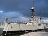
- Averof shipGreek cruiser Georgios AverofGeorgios Averof is a Greek warship which served as the flagship of the Royal Hellenic Navy during most of the first half of the 20th Century...
museum - Village Cinemas Complex
- Kimatothrafstis (Wave-breaker)
- Olympic Tae Kwon Do Stadium
- Phaleron War Cemetery
Historical population
| Year | Population |
|---|---|
| 1981 | 53,273 |
| 1991 | 61,371 |
| 2001 | 64,759 |