

Pahrali
Encyclopedia
Kanyakumari District
Kanyakumari District ) is a district of Tamil Nadu state, India and is the southernmost land area of mainland India.The district is the second most urbanised district in Tamilnadu, next only to Chennai and ahead of Coimbatore. It also has the highest literacy and education levels in the...
in southern India
India
India , officially the Republic of India , is a country in South Asia. It is the seventh-largest country by geographical area, the second-most populous country with over 1.2 billion people, and the most populous democracy in the world...
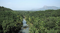
. It originates in the Mahendragiri hills
Mahendragiri
Mahendragiri is the name of a hill in southern Tamil Nadu, near Nagercoil, in Kanyakumari district. It is part of the southern tip of the Western Ghats, with an elevation of ....
. The Mathur Hanging Trough, the highest and longest aqueduct
Aqueduct
An aqueduct is a water supply or navigable channel constructed to convey water. In modern engineering, the term is used for any system of pipes, ditches, canals, tunnels, and other structures used for this purpose....
in Asia
Asia
Asia is the world's largest and most populous continent, located primarily in the eastern and northern hemispheres. It covers 8.7% of the Earth's total surface area and with approximately 3.879 billion people, it hosts 60% of the world's current human population...
, was built over it near Mathur. Perunchani dam
Perunchani Dam
Perunchani Dam is an irrigation dam at Perunchani, Kanyakumari District, in the state of Tamilnadu, India. The Dam area is about from Nagercoil, the administrative headquarters-town of Kanyakumari District, and about from the town of Kulasekhram....
is constructed across Pahrali river.