
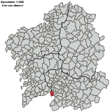
Padrenda
Encyclopedia
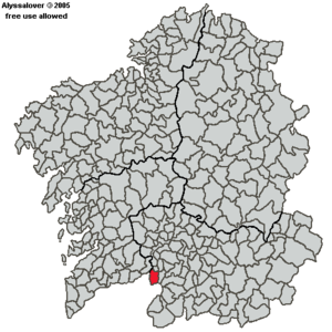
Municipality
A municipality is essentially an urban administrative division having corporate status and usually powers of self-government. It can also be used to mean the governing body of a municipality. A municipality is a general-purpose administrative subdivision, as opposed to a special-purpose district...
in Ourense (province)
Ourense (province)
Ourense is a province of northwestern Spain, in the southeastern part of the Autonomous Community of Galicia. It is bordered by the provinces of Pontevedra in the west, Lugo in the north, León and Zamora in the east, and by Portugal in the south. With an area of 7,278 square km it is the only...
in the Galicia region
Region
Region is most commonly found as a term used in terrestrial and astrophysics sciences also an area, notably among the different sub-disciplines of geography, studied by regional geographers. Regions consist of subregions that contain clusters of like areas that are distinctive by their uniformity...
of north-west Spain
Spain
Spain , officially the Kingdom of Spain languages]] under the European Charter for Regional or Minority Languages. In each of these, Spain's official name is as follows:;;;;;;), is a country and member state of the European Union located in southwestern Europe on the Iberian Peninsula...
.
Population
2.479 citizens according to the 2004 census distributed in 99 different hamlets, and 7 parishes, the density is 43,49 hab./km².Geography
The territory is a very rugged relief, descending the altitude from the South to the North. In the border with Portugal, the mount of Pena Rubia (in the mountain range of Leboreiro) reaches 1227 metres, from there to the river Miño, following the dales of its tributary rivers Deva, Barxas and Gorgua, the lands descend to the 100 metres of altitude.The mountainous territory include the southern and eastern areas of the municipality, with altitudes of 1227 metres, as in Pena Rubia, that has a very smooth topography, very affected by erosion. The flattening territory, in the center and east, (where the villages of Gorgua, Monterredondo and Padrenda are located), is a parallel step next to the previous one. Here is where several streams meet and create the origin of two rivers, Barxas and Gorgua, which form valleys under the limit of 600 metres, which belong to the lower flattening territory (Crespos), that, together with the area of valleys (Condado, Desteriz, Padrenda), descends to the 200m. in Pontebarxas. The landscape is, in short, mountainous to the South, and riverside-like to the North, due to the majestic flowing of the river Miño, which constitutes the main river.