
Pa Hin Ngam National Park
Encyclopedia
Chaiyaphum Province
Chaiyaphum is one of the north-eastern provinces of Thailand. Neighboring provinces are Khon Kaen, Nakhon Ratchasima, Lopburi and Phetchabun.- Etymology :...
in Thailand
Thailand
Thailand , officially the Kingdom of Thailand , formerly known as Siam , is a country located at the centre of the Indochina peninsula and Southeast Asia. It is bordered to the north by Burma and Laos, to the east by Laos and Cambodia, to the south by the Gulf of Thailand and Malaysia, and to the...
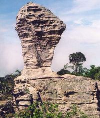
. The name Hin Ngam means beautiful stone, where Pa means forest.
In 1985, the Tep Satit Forestry Department first surveyed the area, long popular with the locals, and recommended its protection. In October 1986, the Pa Hin Ngam Park was created, covering 10 km² around the strange rock formations which gave the park its name. In 1993, the Forestry Department of Thailand conducted a more thorough survey including the surrounding area, and recommended that it become a national park. The national park covering 112 km² was created on September 19, 1994, which was officially gazetted in 2007.
The park is located at the boundary of the Phetchabun mountain range with the Khorat Plateau
Khorat Plateau
The Khorat Plateau also Korat Plateau, is a plateau in the northeastern region of Thailand, named for the short form of Nakhon Ratchasima, an historical stronghold controlling access to and from the plateau.-Geography:...
. The steep cliff at the 846 m high Sut Phan Din viewpoint allows a great view into a valley of the Sonthi River
Sonthi River
The Sonthi River is a tributary of the Pa Sak River. It originates at the Ruak and Phanghoei mountains in the border area of Lam Sonthi district, Lopburi province and Si Thep, Phetchabun province. The river flows southward as the backbone of Lam Sonthi district and joins with the Phaya Klang River...
and the Sap Langka Wildlife Sanctuary. The name Sut Phan Din (สุดแผ่นดิน) means end of land, reflecting the steepness of the cliff. This cliff also marks the watershed
Water divide
A drainage divide, water divide, divide or watershed is the line separating neighbouring drainage basins...
between the Chao Phraya and the Mekong
Mekong
The Mekong is a river that runs through China, Burma, Laos, Thailand, Cambodia and Vietnam. It is the world's 10th-longest river and the 7th-longest in Asia. Its estimated length is , and it drains an area of , discharging of water annually....
rivers.
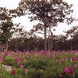
Near the viewpoint is one of the fields of the Siam Tulip
Siam Tulip
The Siam Tulip or Summer Tulip is a tropical plant native to northern Thailand and Cambodia. Despite its name, it is not related to the tulip, but to the various ginger species such as turmeric...
(Curcuma alismatifolia), called Dok Kra Jiao (ดอกกระเจียว) in Thai
Thai language
Thai , also known as Central Thai and Siamese, is the national and official language of Thailand and the native language of the Thai people, Thailand's dominant ethnic group. Thai is a member of the Tai group of the Tai–Kadai language family. Historical linguists have been unable to definitively...
. The dipterocarp forests bloom with the purple flowers at the beginning of the raining season in July.
The park got its name from the strange rock formations in the Hin Ngam Rock Ground, located at the western end of the park. Erosion
Erosion
Erosion is when materials are removed from the surface and changed into something else. It only works by hydraulic actions and transport of solids in the natural environment, and leads to the deposition of these materials elsewhere...
has carved several large rocks into striking and unusual shapes.