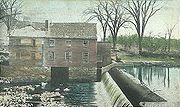
Oyster River (New Hampshire)
Encyclopedia

New Hampshire
New Hampshire is a state in the New England region of the northeastern United States of America. The state was named after the southern English county of Hampshire. It is bordered by Massachusetts to the south, Vermont to the west, Maine and the Atlantic Ocean to the east, and the Canadian...
, United States. It rises in Barrington
Barrington, New Hampshire
Barrington is a town in Strafford County, New Hampshire, United States. The population was 8,576 at the 2010 census. The town is a woodland, farm and bedroom community.-History:...
, flows southeast to Lee
Lee, New Hampshire
Lee is a town in Strafford County, New Hampshire, United States. The population was 4,330 at the 2010 census. The town is a rural farm and bedroom community, being close to the University of New Hampshire.-History:...
, then east-southeast in a serpentine course past Durham
Durham, New Hampshire
As of the census of 2000, there were 12,664 people, 2,882 households, and 1,582 families residing in the town. The population density was 565.5 people per square mile . There were 2,923 housing units at an average density of 130.5 per square mile...
to meet the entrance of Great Bay
Great Bay (New Hampshire)
Great Bay is a tidal estuary located in Strafford and Rockingham counties in eastern New Hampshire, United States. The bay occupies over , not including its several tidal river tributaries. Its outlet is at Hilton Point in Dover, New Hampshire, where waters from the bay flow into the Piscataqua...
into Little Bay. The bays are tidal inlets of the Atlantic Ocean, to which they are connected by a tidal estuary, the Piscataqua River
Piscataqua River
The Piscataqua River, in the northeastern United States, is a long tidal estuary formed by the confluence of the Salmon Falls and Cocheco rivers...
.
The Oyster River reaches tidewater at the base of a dam in the center of Durham, just west of the river's crossing by NH Route 108
New Hampshire Route 108
New Hampshire Route 108 is a long north–south state highway in Rockingham and Strafford counties in southeastern New Hampshire. The northern terminus of the route is in the city of Rochester at NH Route 125 and NH Route 202A...
. Due to silt
Silt
Silt is granular material of a size somewhere between sand and clay whose mineral origin is quartz and feldspar. Silt may occur as a soil or as suspended sediment in a surface water body...
ation, the river is only fully accessible to motorized boats west of the Durham Water Plant for approximately 3 hours on either side of high tide. Boaters have noticed the increasing effect of siltation on navigation since 1998.

