
Oxford, Indiana
Encyclopedia
Oxford is a town in Oak Grove Township
, Benton County
, Indiana
. The population was 1,162 at the 2010 census. It is part of the Lafayette, Indiana
, Metropolitan Statistical Area
.
already bore that name. In October 1843 the commissioners changed it to Hartford, after Hartford, Connecticut
(the home of Ellsworth and Watkins), but they discovered this name was also already being used in Indiana, so in December Judge David J. McConnell awarded the town its present name.
Lots went up for sale at this time, with buyers allowed to pay for the lots in three installments over 18 months. The first building erected in Oxford was a two-story, wooden frame courthouse, designed and built by Francis Boynton, and the second was a hotel, built by Henry L. Ellsworth and operated by James L. Hatton. The first home was that of Aaron Wood, who also ran a small store that supplied groceries, beer and whiskey.
 Other early establishments in Oxford included the Earl & Carnahan dry goods store and Barnes & Dailey drug store. The town's first lawyer was Jacob Benedict and its first physician Dr. Mayo. An 1883 history also makes mention of the community's first literary society, the Oxford Lyceum.
Many additions and expansions to the town were made over subsequent decades, adding several streets and more than 300 lots. On July 7, 1869, a vote was held to determine if Oxford should be incorporated, and passed with 41 in favor and 28 against. The town was dealt a blow, however, when in 1874 it lost its status as county seat to more centrally-located Fowler
.
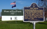
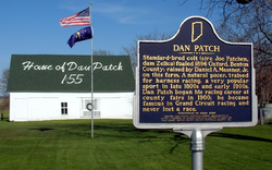
Standardbred horse Dan Patch
is arguably the town's best-known native, and was foaled in an Oxford barn on April 29, 1896. The horse gained celebrity status for setting world speed records that remained unbroken until 1960. He continues to be honored at the town's annual Dan Patch Days festival.
. U.S. Route 52
passes within two miles of the town to the northeast; State Road 352
passes through the town and connects with US 52. State Road 55
also goes through downtown Oxford. The area occupied by the town is mostly open farmland that slopes gently southeast toward Big Pine Creek
.
According to the United States Census Bureau
, the town has a total area of 0.5 square miles (1.3 km²), all of it land.
of 2000, there were 1,271 people, 485 households, and 337 families residing in the town. The population density
was 2,476.0 people per square mile (962.2/km²). There were 514 housing units at an average density of 1,001.3 per square mile (389.1/km²). The racial makeup of the town was 97.88% White, 0.16% African American, 0.08% Native American, 0.08% Asian, 0.71% from other races
, and 1.10% from two or more races. Hispanic or Latino of any race were 1.02% of the population.
There were 485 households out of which 34.6% had children under the age of 18 living with them, 53.2% were married couples
living together, 10.9% had a female householder with no husband present, and 30.5% were non-families. 24.9% of all households were made up of individuals and 15.1% had someone living alone who was 65 years of age or older. The average household size was 2.54 and the average family size was 3.01.
In the town the population was spread out with 26.8% under the age of 18, 7.1% from 18 to 24, 28.5% from 25 to 44, 22.0% from 45 to 64, and 15.6% who were 65 years of age or older. The median age was 38 years. For every 100 females there were 96.4 males. For every 100 females age 18 and over, there were 85.3 males.
The median income for a household in the town was $39,375, and the median income for a family was $45,966. Males had a median income of $31,714 versus $21,630 for females. The per capita income
for the town was $16,472. About 2.1% of families and 5.1% of the population were below the poverty line, including 2.8% of those under age 18 and 11.0% of those age 65 or over.
broadcasts from their studios located in downtown Oxford.
Oak Grove Township, Benton County, Indiana
Oak Grove Township is one of eleven townships in Benton County, Indiana. As of the 2000 census, its population was 1,694. It was one of the first three townships originally created by the county's commissioners in 1840...
, Benton County
Benton County, Indiana
Benton County is located along in the northwest part of the U.S. state of Indiana, along the border with Illinois. As of 2010, the county's population was 8,854. It contains six incorporated towns as well as several small unincorporated settlements; it is also divided into 11 townships which...
, Indiana
Indiana
Indiana is a US state, admitted to the United States as the 19th on December 11, 1816. It is located in the Midwestern United States and Great Lakes Region. With 6,483,802 residents, the state is ranked 15th in population and 16th in population density. Indiana is ranked 38th in land area and is...
. The population was 1,162 at the 2010 census. It is part of the Lafayette, Indiana
Lafayette, Indiana
Lafayette is a city in and the county seat of Tippecanoe County, Indiana, United States, northwest of Indianapolis. As of the 2010 census, the city had a total population of 67,140. West Lafayette, on the other side of the Wabash River, is home to Purdue University, which has a large impact on...
, Metropolitan Statistical Area
Lafayette, Indiana metropolitan area
The Lafayette, Indiana Metropolitan Statistical Area, as defined by the United States Census Bureau, is an area consisting of three counties in Indiana, anchored by the city of Lafayette...
.
History
Oxford was Benton County's first town. Commissioners appointed by the Indiana General Assembly selected the location in May 1843 to be the site of the county seat on land donated by Henry W. Ellsworth and David Watkinson. It was first called Milroy in honor of Samuel Milroy, one of the commissioners, but a town in Rush CountyRush County, Indiana
As of the census of 2000, there were 18,261 people, 6,923 households, and 5,046 families residing in the county. The population density was 45 people per square mile . There were 7,337 housing units at an average density of 18 per square mile...
already bore that name. In October 1843 the commissioners changed it to Hartford, after Hartford, Connecticut
Hartford, Connecticut
Hartford is the capital of the U.S. state of Connecticut. The seat of Hartford County until Connecticut disbanded county government in 1960, it is the second most populous city on New England's largest river, the Connecticut River. As of the 2010 Census, Hartford's population was 124,775, making...
(the home of Ellsworth and Watkins), but they discovered this name was also already being used in Indiana, so in December Judge David J. McConnell awarded the town its present name.
Lots went up for sale at this time, with buyers allowed to pay for the lots in three installments over 18 months. The first building erected in Oxford was a two-story, wooden frame courthouse, designed and built by Francis Boynton, and the second was a hotel, built by Henry L. Ellsworth and operated by James L. Hatton. The first home was that of Aaron Wood, who also ran a small store that supplied groceries, beer and whiskey.
Many additions and expansions to the town were made over subsequent decades, adding several streets and more than 300 lots. On July 7, 1869, a vote was held to determine if Oxford should be incorporated, and passed with 41 in favor and 28 against. The town was dealt a blow, however, when in 1874 it lost its status as county seat to more centrally-located Fowler
Fowler, Indiana
-External links:*...
.
Standardbred horse Dan Patch
Dan Patch
Dan Patch was the outstanding pacer of his day. Dan Patch broke world speed records at least 14 times in the early 1900s, finally setting the world's record for the fastest mile by a harness horse during a time trial in 1906, a record that stood unmatched for 32 years.-Life:He was a brown...
is arguably the town's best-known native, and was foaled in an Oxford barn on April 29, 1896. The horse gained celebrity status for setting world speed records that remained unbroken until 1960. He continues to be honored at the town's annual Dan Patch Days festival.
Geography
Oxford is located at 40°31′17"N 87°14′59"W (40.521381, -87.249840) in Oak Grove TownshipOak Grove Township, Benton County, Indiana
Oak Grove Township is one of eleven townships in Benton County, Indiana. As of the 2000 census, its population was 1,694. It was one of the first three townships originally created by the county's commissioners in 1840...
. U.S. Route 52
U.S. Route 52
U.S. Route 52 is a United States highway that runs across the northern, eastern and southeastern regions of the United States. Contrary to most other even-numbered U.S...
passes within two miles of the town to the northeast; State Road 352
Indiana State Road 352
State Road 352 in the U.S. state of Indiana is an east–west state highway in Benton County in the west-central part of the state.-Route description:...
passes through the town and connects with US 52. State Road 55
Indiana State Road 55
State Road 55 is a north–south road in Northern and Central Indiana. State Road 55 runs from the Crawfordsville area in the south to Gary in the north, a distance of approximately .-Route description:...
also goes through downtown Oxford. The area occupied by the town is mostly open farmland that slopes gently southeast toward Big Pine Creek
Big Pine Creek (Indiana)
Big Pine Creek is a creek in northwestern Indiana, USA. It begins in Round Grove Township in southwestern White County and flows generally southward through Benton and Warren counties before meeting the Wabash River near the town of Attica...
.
According to the United States Census Bureau
United States Census Bureau
The United States Census Bureau is the government agency that is responsible for the United States Census. It also gathers other national demographic and economic data...
, the town has a total area of 0.5 square miles (1.3 km²), all of it land.
Demographics
As of the censusCensus
A census is the procedure of systematically acquiring and recording information about the members of a given population. It is a regularly occurring and official count of a particular population. The term is used mostly in connection with national population and housing censuses; other common...
of 2000, there were 1,271 people, 485 households, and 337 families residing in the town. The population density
Population density
Population density is a measurement of population per unit area or unit volume. It is frequently applied to living organisms, and particularly to humans...
was 2,476.0 people per square mile (962.2/km²). There were 514 housing units at an average density of 1,001.3 per square mile (389.1/km²). The racial makeup of the town was 97.88% White, 0.16% African American, 0.08% Native American, 0.08% Asian, 0.71% from other races
Race (United States Census)
Race and ethnicity in the United States Census, as defined by the Federal Office of Management and Budget and the United States Census Bureau, are self-identification data items in which residents choose the race or races with which they most closely identify, and indicate whether or not they are...
, and 1.10% from two or more races. Hispanic or Latino of any race were 1.02% of the population.
There were 485 households out of which 34.6% had children under the age of 18 living with them, 53.2% were married couples
Marriage
Marriage is a social union or legal contract between people that creates kinship. It is an institution in which interpersonal relationships, usually intimate and sexual, are acknowledged in a variety of ways, depending on the culture or subculture in which it is found...
living together, 10.9% had a female householder with no husband present, and 30.5% were non-families. 24.9% of all households were made up of individuals and 15.1% had someone living alone who was 65 years of age or older. The average household size was 2.54 and the average family size was 3.01.
In the town the population was spread out with 26.8% under the age of 18, 7.1% from 18 to 24, 28.5% from 25 to 44, 22.0% from 45 to 64, and 15.6% who were 65 years of age or older. The median age was 38 years. For every 100 females there were 96.4 males. For every 100 females age 18 and over, there were 85.3 males.
The median income for a household in the town was $39,375, and the median income for a family was $45,966. Males had a median income of $31,714 versus $21,630 for females. The per capita income
Per capita income
Per capita income or income per person is a measure of mean income within an economic aggregate, such as a country or city. It is calculated by taking a measure of all sources of income in the aggregate and dividing it by the total population...
for the town was $16,472. About 2.1% of families and 5.1% of the population were below the poverty line, including 2.8% of those under age 18 and 11.0% of those age 65 or over.
Media
Oxford is home to Benton County's only radio station. Located at 98.1 MHz, WIBNWIBN
WIBN is an FM radio station licensed to the city of Earl Park, Indiana. The station operates on the FM radio frequency of 98.1 MHz, FM channel 251. The studios are located at 130 E. McConnell Street in Oxford, Indiana...
broadcasts from their studios located in downtown Oxford.