

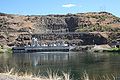
Oxbow Dam
Encyclopedia
Oxbow Dam is a hydroelectric
run-of-the-river
rockfill dam
on the Snake River
on the Idaho
-Oregon
border, in Hells Canyon
(river mile
273). It is part of the Hells Canyon Project that also includes Hells Canyon Dam
and Brownlee Dam
, built and operated by Idaho Power Company
.
The dam's powerhouse contains four generating units with a total nameplate capacity of 190 megawatts.
Lacking passage for migrating salmon
, the three Hells Canyon Project dams blocked access by anadromous salmonids to a stretch of the Snake River drainage basin
from Hells Canyon Dam up to Shoshone Falls
, which naturally prevents any upstream fish passage to the upper Snake River basin.
owned by Idaho Power Company
.
Hydroelectricity
Hydroelectricity is the term referring to electricity generated by hydropower; the production of electrical power through the use of the gravitational force of falling or flowing water. It is the most widely used form of renewable energy...
run-of-the-river
Run-of-the-river hydroelectricity
Run-of-the-river hydroelectricity is a type of hydroelectric generation whereby a considerably smaller water storage called pondage or none is used to supply a power station. Run-of-the-river power plants are classified as with or without pondage...
rockfill dam
Dam
A dam is a barrier that impounds water or underground streams. Dams generally serve the primary purpose of retaining water, while other structures such as floodgates or levees are used to manage or prevent water flow into specific land regions. Hydropower and pumped-storage hydroelectricity are...
on the Snake River
Snake River
The Snake is a major river of the greater Pacific Northwest in the United States. At long, it is the largest tributary of the Columbia River, the largest North American river that empties into the Pacific Ocean...
on the Idaho
Idaho
Idaho is a state in the Rocky Mountain area of the United States. The state's largest city and capital is Boise. Residents are called "Idahoans". Idaho was admitted to the Union on July 3, 1890, as the 43rd state....
-Oregon
Oregon
Oregon is a state in the Pacific Northwest region of the United States. It is located on the Pacific coast, with Washington to the north, California to the south, Nevada on the southeast and Idaho to the east. The Columbia and Snake rivers delineate much of Oregon's northern and eastern...
border, in Hells Canyon
Hells Canyon
Hells Canyon is a wide canyon located along the border of eastern Oregon and western Idaho in the United States. It is North America's deepest river gorge at and part of the Hells Canyon National Recreation Area....
(river mile
River mile
In the United States, a River mile is a measure of distance in miles along a river from its mouth. River mile numbers begin at zero and increase further upstream. The corresponding metric unit using kilometers is the River kilometer...
273). It is part of the Hells Canyon Project that also includes Hells Canyon Dam
Hells Canyon Dam
Hells Canyon Dam is a concrete gravity dam on the Snake River in Hells Canyon on the Idaho-Oregon border. The dam impounds the Snake River in Hells Canyon Reservoir; its spillway elevation is above sea level....
and Brownlee Dam
Brownlee Dam
Brownlee Dam is a hydroelectric earth fill embankment dam on the Snake River on the Idaho-Oregon border, in Hells Canyon . It impounds the Snake River in the long Brownlee Reservoir...
, built and operated by Idaho Power Company
Idaho Power Company
Idaho Power Company is a regulated electrical power utility. Its business involves the purchase, sale, generation, transmission and distribution of electricity in eastern Oregon and southern Idaho. It is a subsidiary of IDACORP, Inc...
.
The dam's powerhouse contains four generating units with a total nameplate capacity of 190 megawatts.
Lacking passage for migrating salmon
Salmon
Salmon is the common name for several species of fish in the family Salmonidae. Several other fish in the same family are called trout; the difference is often said to be that salmon migrate and trout are resident, but this distinction does not strictly hold true...
, the three Hells Canyon Project dams blocked access by anadromous salmonids to a stretch of the Snake River drainage basin
Drainage basin
A drainage basin is an extent or an area of land where surface water from rain and melting snow or ice converges to a single point, usually the exit of the basin, where the waters join another waterbody, such as a river, lake, reservoir, estuary, wetland, sea, or ocean...
from Hells Canyon Dam up to Shoshone Falls
Shoshone Falls
Shoshone Falls is a waterfall on the Snake River located approximately five miles east of Twin Falls, Idaho. Sometimes called the "Niagara of the West," Shoshone Falls is 212 feet high—45 feet higher than Niagara Falls—and flows over a rim 1,000 feet wide.A park overlooking the waterfall is...
, which naturally prevents any upstream fish passage to the upper Snake River basin.
Heliport
Oxbow Heliport is a private 100 by 100 ft (30.5 m). (30 x 30 m), turf heliportHeliport
A heliport is a small airport suitable only for use by helicopters. Heliports typically contain one or more helipads and may have limited facilities such as fuel, lighting, a windsock, or even hangars...
owned by Idaho Power Company
Idaho Power Company
Idaho Power Company is a regulated electrical power utility. Its business involves the purchase, sale, generation, transmission and distribution of electricity in eastern Oregon and southern Idaho. It is a subsidiary of IDACORP, Inc...
.
See also
- Copperfield, OregonCopperfield, OregonCopperfield is a former town in Baker County, Oregon, United States, located on the west bank of the Snake River, near a place called The Oxbow.-Early history:...
- Oxbow, OregonOxbow, OregonOxbow is an unincorporated community in Baker County, Oregon, United States. Oxbow is located on Oregon Route 86 next to the Snake River near the Oxbow Dam on the Oregon-Idaho border, about 17 miles northeast of Halfway. Oxbow is just south of the site of the former mining town of Copperfield...