
Oregon Route 173
Encyclopedia
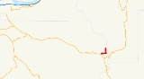
Oregon Route 173 is an Oregon
state highway
running from Timberline Lodge in Clackamas County
to U.S. Route 26 near Government Camp
. OR 173 is known as the Timberline Highway No. 173 (see Oregon highways and routes). It is 5.37 miles (8.6 km) long and runs in a northeast to southwest "L" pattern, entirely within Clackamas County.http://www.oregon.gov/ODOT/HWY/TRAFFIC/TEOS_Publications/PDF/Descriptions_of_US_and_Oregon_Routes.pdf,[ftp://ftp.odot.state.or.us/tdb/trandata/maps/slchart_pdfs_1980_to_2002/Hwy173_1997.pdf]
OR 173 was established in 2002 as part of Oregon's project to assign route numbers to highways that previously were not assigned, and, as of September 2010, was unsigned.
to an intersection with US 26 approximately one mile east of Government Camp, where it ends.[ftp://ftp.odot.state.or.us/tdb/trandata/maps/slchart_pdfs_1980_to_2002/Hwy173_1997.pdf]
[ftp://ftp.odot.state.or.us/tdb/trandata/maps/slchart_pdfs_1980_to_2002/Hwy173_1997.pdf]
Oregon
Oregon is a state in the Pacific Northwest region of the United States. It is located on the Pacific coast, with Washington to the north, California to the south, Nevada on the southeast and Idaho to the east. The Columbia and Snake rivers delineate much of Oregon's northern and eastern...
state highway
State highway
State highway, state road or state route can refer to one of three related concepts, two of them related to a state or provincial government in a country that is divided into states or provinces :#A...
running from Timberline Lodge in Clackamas County
Clackamas County, Oregon
Clackamas County is a county located in the U.S. state of Oregon. The county was named after the Native Americans living in the area, the Clackamas Indians, who were part of the Chinookan people. As of 2010, the population was 375,992...
to U.S. Route 26 near Government Camp
Government Camp, Oregon
Government Camp is an unincorporated community located in Clackamas County, Oregon, United States, south of Mount Hood and north of Tom, Dick and Harry Mountain. It is a gateway to several ski resorts, the most popular being Timberline Lodge and Mount Hood Skibowl. Also, Government Camp has its...
. OR 173 is known as the Timberline Highway No. 173 (see Oregon highways and routes). It is 5.37 miles (8.6 km) long and runs in a northeast to southwest "L" pattern, entirely within Clackamas County.http://www.oregon.gov/ODOT/HWY/TRAFFIC/TEOS_Publications/PDF/Descriptions_of_US_and_Oregon_Routes.pdf,[ftp://ftp.odot.state.or.us/tdb/trandata/maps/slchart_pdfs_1980_to_2002/Hwy173_1997.pdf]
OR 173 was established in 2002 as part of Oregon's project to assign route numbers to highways that previously were not assigned, and, as of September 2010, was unsigned.
Route description
OR 173 begins at Timberline Lodge. It heads south and then west down Mount HoodMount Hood
Mount Hood, called Wy'east by the Multnomah tribe, is a stratovolcano in the Cascade Volcanic Arc of northern Oregon. It was formed by a subduction zone and rests in the Pacific Northwest region of the United States...
to an intersection with US 26 approximately one mile east of Government Camp, where it ends.[ftp://ftp.odot.state.or.us/tdb/trandata/maps/slchart_pdfs_1980_to_2002/Hwy173_1997.pdf]
History
OR 173 was assigned to the Timberline Highway in 2002.http://www.oregon.gov/ODOT/HWY/TRAFFIC/TEOS_Publications/PDF/Descriptions_of_US_and_Oregon_Routes.pdfMajor intersections
| Milepost | City | Intersection |
|---|---|---|
| 0.12 | Timberline Lodge | Beginning of Route |
| 5.49 | Near Government Camp Government Camp, Oregon Government Camp is an unincorporated community located in Clackamas County, Oregon, United States, south of Mount Hood and north of Tom, Dick and Harry Mountain. It is a gateway to several ski resorts, the most popular being Timberline Lodge and Mount Hood Skibowl. Also, Government Camp has its... |
U.S. Route 26 |
[ftp://ftp.odot.state.or.us/tdb/trandata/maps/slchart_pdfs_1980_to_2002/Hwy173_1997.pdf]