

Oregon Outback
Encyclopedia
High Desert (Oregon)
The Oregon High Desert is a region of the U.S. state of Oregon, located east of the Cascade Range and south of the Blue Mountains, in the central and eastern parts of the state. Divided into a southern region and a northern region, the desert covers most of five Oregon counties and averages above...
Basin and Range
Basin and Range
The Basin and Range Province is a vast physiographic region defined by a unique topographic expression. Basin and Range topography is characterized by abrupt changes in elevation, alternating between narrow faulted mountain chains and flat arid valleys or basins...
country of the central southern portion of the U.S. state
U.S. state
A U.S. state is any one of the 50 federated states of the United States of America that share sovereignty with the federal government. Because of this shared sovereignty, an American is a citizen both of the federal entity and of his or her state of domicile. Four states use the official title of...
of Oregon
Oregon
Oregon is a state in the Pacific Northwest region of the United States. It is located on the Pacific coast, with Washington to the north, California to the south, Nevada on the southeast and Idaho to the east. The Columbia and Snake rivers delineate much of Oregon's northern and eastern...
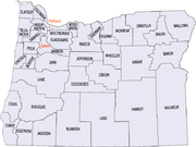
and is most of Lake
Lake County, Oregon
Lake County is a county in the high desert south central region of the U.S. state of Oregon, so named for the many lakes found within its boundaries, including Lake Abert, Hart Lake Reservoir, and Goose Lake. While Lake is among Oregon's largest counties, it is sparsely populated with 7,895...
and Klamath County
Klamath County, Oregon
-National protected areas:* Bear Valley National Wildlife Refuge* Crater Lake National Park * Deschutes National Forest * Fremont National Forest * Klamath Marsh National Wildlife Refuge* Lower Klamath National Wildlife Refuge...
.
There is also the Oregon Outback Rural Fire Protection District which is a 35 square miles (90.6 km²) rural area in northern Klamath County and is based in La Pine
La Pine, Oregon
La Pine is a city in Deschutes County, Oregon, United States, incorporated on December 7, 2006.La Pine is part of the Bend, Oregon Metropolitan Statistical Area. The population was 5,799 at the 2000 census, at which time it was a census-designated place . La Pine is in an isolated area of Central...
(6 miles north of the southern Deschutes County
Deschutes County, Oregon
-National protected areas:* Deschutes National Forest * Newberry National Volcanic Monument-Demographics:As of the census of 2000, there were 115,367 people, 45,595 households, and 31,962 families residing in the county. The population density was 38 people per square mile . There were 54,583...
border).
Climate
The region is arid with an average of about ten inches of annual rainfall, though some mountain areas may receive as much as thirty inches, mostly in the form of winter snow and summer thunderstorms. Winters are cold and windy with periodic snowfalls; spring brings warm days and cold nights with snow possible into late April. Summer is warm with cool nights and occasional thunderstorms, with fall bringing crisp weather that can be interrupted by snow as soon as late October.Topography
The region is a high desert plateauPlateau
In geology and earth science, a plateau , also called a high plain or tableland, is an area of highland, usually consisting of relatively flat terrain. A highly eroded plateau is called a dissected plateau...
averaging roughly 4000 feet (1,219.2 m) in elevation, periodically broken by sometimes massive fault-block mountain
Fault-block mountain
Fault-block landforms are formed when large areas of bedrock are widely broken up by faults creating large vertical displacements of continental crust....
s.
Notable fault blocks in the region are Abert Rim
Abert Rim
Abert Rim in Lake County, Oregon is one of the highest fault scarps in the United States. It rises 760 meters above the valley floor, finishing with an 250-meter sheer-sided basalt cap. It was formed during the Miocene epoch. At that time basaltic flood lavas covered much of eastern Oregon...
, Winter Ridge, Diablo Rim, Fish Creek Rim, Hart Mountain
Hart Mountain
Hart Mountain is a fault-block mountain, in Lake County, Oregon, USA. It lies about to the east of Lakeview.It is sometimes confused with a mountain range, but is more properly described as one mountain. The two highest peaks are Warner Peak and Hart Peak.The top of the mountain is part of the...
, and Poker Jim Ridge. Large lakes abound throughout the region as the streams of the Great Basin
Great Basin
The Great Basin is the largest area of contiguous endorheic watersheds in North America and is noted for its arid conditions and Basin and Range topography that varies from the North American low point at Badwater Basin to the highest point of the contiguous United States, less than away at the...
have no outlet to the sea and empty themselves on the basin floor. The Warner Lakes
Warner Lakes
The Warner Lakes are a chain of shallow lakes and marshes in the Warner Valley of eastern Lake County, Oregon, United States. The lakes extend the length of the valley, covering approximately ....
are the largest cluster of these shallow basin lakes. The lakes contain fish, notably crappie
Crappie
Crappie is a genus of freshwater fish in the sunfish family of order Perciformes. The type species is P. annularis, the white crappie...
in the Warner Lakes, and host numerous bird species.
Fauna
Mule DeerMule Deer
The mule deer is a deer indigenous to western North America. The Mule Deer gets its name from its large mule-like ears. There are believed to be several subspecies, including the black-tailed deer...
are one of the most common large mammals encountered in the Outback. Pronghorn
Pronghorn
The pronghorn is a species of artiodactyl mammal endemic to interior western and central North America. Though not an antelope, it is often known colloquially in North America as the prong buck, pronghorn antelope, or simply antelope, as it closely resembles the true antelopes of the Old World and...
are also a common species; in fact, the herd protected on the Hart Mountain National Antelope Refuge
Hart Mountain National Antelope Refuge
Hart Mountain National Antelope Refuge is a National Wildlife Refuge on Hart Mountain in southeastern Oregon, which protects more than and more than 300 species of wildlife, including pronghorn antelope, bighorn sheep, mule deer, sage grouse, and redband trout...
is one of the largest in North America. Another unique large mammal is the Kiger Mustang
Kiger Mustang
Kiger Mustang is substrain of Mustang horse located in the southeastern part of U.S. state of Oregon. Originally feral horses with specific conformation traits discovered in 1977, the name also applies to their bred-in-captivity progeny....
; these feral horses are direct descendants of Spanish mustangs that escaped from the conquistador
Conquistador
Conquistadors were Spanish soldiers, explorers, and adventurers who brought much of the Americas under the control of Spain in the 15th to 16th centuries, following Europe's discovery of the New World by Christopher Columbus in 1492...
s long ago in the southwest.
Ownership
Much of the area is publicly owned, primarily under Bureau of Land ManagementBureau of Land Management
The Bureau of Land Management is an agency within the United States Department of the Interior which administers America's public lands, totaling approximately , or one-eighth of the landmass of the country. The BLM also manages of subsurface mineral estate underlying federal, state and private...
(BLM) control. Some large areas are specially designated for protection, such as the Steens Mountain Wilderness
Steens Mountain Wilderness
Steens Mountain Wilderness is a wilderness area surrounding a portion of Steens Mountain of southeastern Oregon, U.S. The reserve falls within the Steens Mountain Cooperative Management and Protection Area . Both the reserve and the CMPA are administered by the Bureau of Land Management. The...
complex, Hart Mountain National Antelope Refuge
Hart Mountain National Antelope Refuge
Hart Mountain National Antelope Refuge is a National Wildlife Refuge on Hart Mountain in southeastern Oregon, which protects more than and more than 300 species of wildlife, including pronghorn antelope, bighorn sheep, mule deer, sage grouse, and redband trout...
and the Malheur National Wildlife Refuge. Though access to most areas is readily available because the land is publicly owned, use is relatively light because of the extreme isolation of the land. A recent controversy involves the grazing of domestic livestock on public lands. A century old practice, public grazing in many areas has recently led environmentalists to decry the practice as harmful to the fragile and unique desert ecosystems. In fact, this controversy led to the creation of the Steens Mountain Wilderness
Steens Mountain Wilderness
Steens Mountain Wilderness is a wilderness area surrounding a portion of Steens Mountain of southeastern Oregon, U.S. The reserve falls within the Steens Mountain Cooperative Management and Protection Area . Both the reserve and the CMPA are administered by the Bureau of Land Management. The...
, which includes some of the only designated livestock free zones in the nation.
Counties
| County Name | Population (2006) | Area |
|---|---|---|
| Klamath Klamath County, Oregon -National protected areas:* Bear Valley National Wildlife Refuge* Crater Lake National Park * Deschutes National Forest * Fremont National Forest * Klamath Marsh National Wildlife Refuge* Lower Klamath National Wildlife Refuge... |
65,455 | 15,892 km² (6,136 mi²) |
| Lake Lake County, Oregon Lake County is a county in the high desert south central region of the U.S. state of Oregon, so named for the many lakes found within its boundaries, including Lake Abert, Hart Lake Reservoir, and Goose Lake. While Lake is among Oregon's largest counties, it is sparsely populated with 7,895... |
7,540 | 21,648 km² (8,358 mi²) |
Cities and towns
ChemultChemult, Oregon
Chemult is an unincorporated community in Klamath County, Oregon, United States, on U.S. Route 97. Chemult has a population of about 300 people. Chemult's elevation is ....
|
Chiloquin
Chiloquin, Oregon
Chiloquin is a city in Klamath County, Oregon, United States. Chiloquin was the pioneer version of a Klamath family name Chaloquin, which was the name of a Klamath chief who was alive at the time of the treaty of 1864...
|
Christmas Valley
Christmas Valley, Oregon
Christmas Valley is an unincorporated community in Lake County, Oregon, United States. The community was named after nearby dry Christmas Lake, east of the present townsite and the site of the former Lake post office, which ran from 1906 until 1943. Real estate development around a planned...
|
Fort Rock
Fort Rock, Oregon
Fort Rock is an unincorporated community in Lake County, Oregon, United States, southeast of Fort Rock State Natural Area.The community of Fort Rock was named after the natural feature Fort Rock by the town's founder, Ray Nash. Fort Rock post office was established in 1908 under postmaster Josiah...
|
Klamath Falls
Klamath Falls, Oregon
Klamath Falls is a city in Klamath County, Oregon, United States. Originally called Linkville when George Nurse founded the town in 1867, after the Link River on whose falls this city sat, although no falls currently exist; the name was changed to Klamath Falls in 1892...
|
Lakeview
Lakeview, Oregon
Lakeview is a city in Lake County, Oregon, United States. The population was 2,294 at the 2010 census. It is the county seat of Lake County. Although it is an incorporated city, the municipal government refers to the community as "The Town of Lakeview", and bills itself as "Tallest Town in Oregon"...
|
Silver Lake
Silver Lake, Oregon
Silver Lake is an unincorporated community in Lake County, Oregon, United States. It is located on Oregon Route 31. Facilities include a gas station and a small store. It is also the location of North Lake School, "Home of the Cowboys".- History :...
|
Summer Lake
Summer Lake, Oregon
Summer Lake is an unincorporated community in northern Lake County, Oregon, United States. It is located on Oregon Route 31 approximately halfway between Bend and Lakeview...
|
See also
- Southern OregonSouthern OregonSouthern Oregon is a region of the U.S. state of Oregon south of Lane County and generally west of the Cascade Range, excluding the southern Oregon Coast. Counties include Douglas, Jackson, Klamath, and Josephine. It includes the Southern Oregon American Viticultural Area, which consists of the...
- Central OregonCentral OregonCentral Oregon is a geographic region in the U.S. state of Oregon and is traditionally considered to be made up of Deschutes, Jefferson, and Crook counties. Other definitions include larger areas, often encompassing areas to the north towards the Columbia River, eastward towards Burns, or south...
- Southeastern OregonSoutheastern OregonSoutheastern Oregon is a geographical term for the area along the state of Oregon's borders with Idaho, California, and Nevada. It includes the populous areas of Burns, Klamath Falls and Lakeview.-Counties:-Cities and towns:Burns |Chemult |Chiloquin |...
- Eastern OregonEastern OregonEastern Oregon is the eastern part of the U.S. state of Oregon. It is not an officially recognized geographic entity, thus the boundaries of the region vary according to context. It is sometimes understood to include only the eight easternmost counties in the state; in other contexts, it includes...