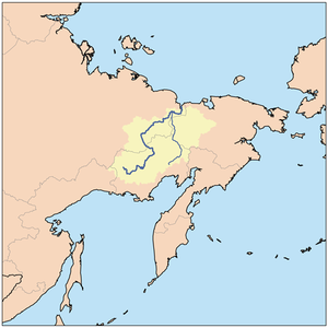
Omolon River
Encyclopedia

Kolyma River
The Kolyma River is a river in northeastern Siberia, whose basin covers parts of the Sakha Republic, Chukotka Autonomous Okrug, and Magadan Oblast of Russia. Itrises in the mountains north of Okhotsk and Magadan, in the area of and...
in northeast Siberia. The length of the river is 1150 kilometres (714.6 mi). The area of its basin 118,600 km². The Omolon River freezes up in October and stays under ice until late May - early June. The lower 600 kilometres (372.8 mi) are navigable.
It begins in the Magadan Oblast
Magadan Oblast
Magadan Oblast is a federal subject of Russia in the Far Eastern Federal District. Its administrative center is the city of Magadan....
less than 100 kilometres (62.1 mi) from the Sea of Okhotsk, flows north, forms part of the border of Magdan and Chukotka
Chukotka Autonomous Okrug
Chukotka Autonomous Okrug , or Chukotka , is a federal subject of Russia located in the Russian Far East.Chukotka has a population of 53,824 according to the 2002 Census, and a surface area of . The principal town and the administrative center is Anadyr...
, crosses Chukota, briefly enters the Sakha Republic and joins the Kolyma about 125 kilometres (77.7 mi) from the Arctic. Its basin is surrounded by: (west) branches of the Kolyma, (south) Penzhina River and others that flow south, (east) Anadyr River
Anadyr River
Anadyr is a river in the far northeast Siberia which flows into Anadyr Bay of the Bering Sea and drains much of the interior of Chukotka Autonomous Okrug. Its basin corresponds to the Anadyrsky District of Chukotka....
and (northeast) Bolshoy Anyuy River
Bolshoy Anyuy River
The Bolshoy Anyuy River or Bolshoy Anyui River is a river in the Kolyma River basin in Far East Siberia. It flows roughly westwards and passes through the sparsely populated areas of Chukotka...
. The upper Omolon is subalpine in the highlands, the middle is boreal forest and the lower part tundra. The is a Zakaznik
Zakaznik
Zakaznik is a type of protected area in Russia and other former Soviet republics such as Ukraine that meets World Conservation Union's category III, or more frequently category VII criteria....
in Chukotka to protect the forests.
Its main tributaries are the Molongda, the west-flowing Oloy River
Oloy River
The Oloy River is a river in Magadan Oblast in Russia, a right tributary of the Omolon River . The length of the river is . The area of its drainage basin is 23,100 km². It flows roughly northwestwards and passes through the sparsely populated areas of Chukotka. This river meets the Kolyma at...
(at 471 kilometres (292.7 mi), the largest tributary), Oloychan, Kedon.

