

Ohio State Highway 303
Encyclopedia
State highway
State highway, state road or state route can refer to one of three related concepts, two of them related to a state or provincial government in a country that is divided into states or provinces :#A...
in northern portion of the U.S. state
U.S. state
A U.S. state is any one of the 50 federated states of the United States of America that share sovereignty with the federal government. Because of this shared sovereignty, an American is a citizen both of the federal entity and of his or her state of domicile. Four states use the official title of...
of Ohio
Ohio
Ohio is a Midwestern state in the United States. The 34th largest state by area in the U.S.,it is the 7th‑most populous with over 11.5 million residents, containing several major American cities and seven metropolitan areas with populations of 500,000 or more.The state's capital is Columbus...
. Its western terminus is at U.S. Route 20 in Wakeman
Wakeman, Ohio
Wakeman is a village in Huron County, Ohio, United States, along the Vermilion River and is named after Jesup Wakeman, an early settler of Fairfield County, Connecticut, who was involved in western land speculation between 1800 and 1840....
, and its eastern terminus is 1.28 miles (2.1 km) east of Windham
Windham, Ohio
Windham is a village located in Portage County, Ohio, United States. It is formed from portions of Windham Township, one of the original townships of the Connecticut Western Reserve. The population was 2,209 at the 2010 census. In 1942, the US government chose Windham as the site of an army camp...
. Signage photos from 2003 showed that the route apparently ended at State Route 534 and was co-signed with State Route 82 (this concurrency would be less than ½ mile). In fact, before the construction of the Ohio Turnpike
Ohio Turnpike
The Ohio Turnpike, officially the James W. Shocknessy Ohio Turnpike, is a -long, limited-access toll highway in the U.S. state of Ohio, serving as a primary corridor to Chicago and Pittsburgh...
, State Route 303 did intersect with State Route 534, as seen in highway maps from 1940. However the Technical Straight Line Diagram for State Route 303 in Trumbull County shows that SR 303 now ends at State Route 82, and signs now reflect that fact.
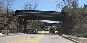
State Route 303 passes through Cuyahoga Valley National Park
Cuyahoga Valley National Park
Cuyahoga Valley National Park preserves and reclaims the rural landscape along the Cuyahoga River between Akron and Cleveland in Northeast Ohio. The park is the only national park in Ohio.Cuyahoga means "crooked river" in Mohawk....
. East of Richfield, a widened section of road with left turn lanes that apparently go nowhere reveals the former site of the Richfield Coliseum.
Major intersections
History
- 1933 – Original route established; originally routed from RichfieldRichfield, OhioRichfield is a village in Summit County, Ohio, United States. The population was 3,286 at the 2000 census. The village and the adjacent Richfield Township are approximately equidistant between the downtown areas of Akron and Cleveland...
to HudsonHudson, OhioHudson is a city in Summit County, Ohio, United States. The population was 22,262 at the 2010 census. It is an affluent exurban community and is part of the Akron, Ohio Metropolitan Statistical Area...
along its current alignment. - 1934 – Extended east to StreetsboroStreetsboro, OhioStreetsboro is a city in Portage County, Ohio, United States. It is formed from the former township of Streetsboro, which was formed from the Connecticut Western Reserve. It is nearly co-extant with the former Streetsboro Township; the village of Sugar Bush Knolls was also formed in part from a...
via a previously unnumbered road. - 1938 – Extended west to WakemanWakeman, OhioWakeman is a village in Huron County, Ohio, United States, along the Vermilion River and is named after Jesup Wakeman, an early settler of Fairfield County, Connecticut, who was involved in western land speculation between 1800 and 1840....
via previously unnumbered roads from Wakeman to Pittsfield and from Belden to Richfield, and along the alignment of former State Route 200 from Pittsfield to Belden; also extended east to a point four miles (6 km) east of Windham. - circa 1954 – Its eastern terminus was moved less than ½ mile west of State Route 534 on State Route 82 when the Ohio TurnpikeOhio TurnpikeThe Ohio Turnpike, officially the James W. Shocknessy Ohio Turnpike, is a -long, limited-access toll highway in the U.S. state of Ohio, serving as a primary corridor to Chicago and Pittsburgh...
was constructed.