
Ocotillo Wells, California
Encyclopedia
Ocotillo Wells is an unincorporated community
in San Diego County, California
. It is 3 miles (4.8 km) west of the Imperial County
line on State Route 78
at an elevation of 163 feet (49.7 m). The name became official in 1962 when it was adopted for federal use by the Board of Geographic Names
. A federally-recognized variant name, Ocotillo, can cause confusion. The community of Ocotillo
, in Imperial County, is only 29 miles (46.7 km) to the southeast.
The ZIP Code
is 92004 and the community is in area code 760
. The prefix for wired telephones is 767, which is shared with Borrego Springs
.
(18 miles (29 km) east) and at the Blu-In Cafe (3 miles (4.8 km) east). Gas may not always be available the Blu-In Cafe which, besides the gas station, operates a restaurant, store, and RV park
.
Several other small businesses sell off-road accessories and rent all-terrain vehicle
s. Most businesses in the area are closed during the summer months. My Desert Rose, which was a traditional restaurant located at the intersection of Highway 78 and Split Mountain Road, burned down in 2008.
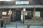 The Split Mountain Store and the Iron Door are located about 1 miles (1.6 km) south of Highway 78 on Split Mountain Road. Both of these businesses are open part time during the summer and full time during the cooler months. The Split Mountain Store stocks a little bit of everything including groceries, beer, and parts for sand buggies and trucks. The Iron Door, a small bar, has a private club, two pool tables and serves beer, wine and some food. Countless local artifacts are on display in the bar, where several layers of decorated dollar bills are stapled to the walls.The iron has had some celebrity clientele Clint Eastwood wore an iron door shirt in one of his movies
operates the Ocotillo Wells State Vehicle Recreation Area which borders the community. This off-road vehicle
area is part of the department's Southern Division, Ocotillo Wells District which is headquartered in Borrego Springs.
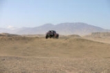
Free camping is available at numerous locations along State Route 78. The most popular of these are Main Street, Holmes Camp, County Line Road, and Pole Line Road. Each of these areas have ample access to numerous trails that provide a challenge to riders of all skill levels. A wide variety of off road vehicles can be operated within the park. Any vehicle with a license plate or off road registration is legal.
Features in the park include:
A map of these locations as well as numerous other trails is available at the ranger station.
Unincorporated area
In law, an unincorporated area is a region of land that is not a part of any municipality.To "incorporate" in this context means to form a municipal corporation, a city, town, or village with its own government. An unincorporated community is usually not subject to or taxed by a municipal government...
in San Diego County, California
San Diego County, California
San Diego County is a large county located in the southwestern corner of the US state of California. Hence, San Diego County is also located in the southwestern corner of the 48 contiguous United States. Its county seat and largest city is San Diego. Its population was about 2,813,835 in the 2000...
. It is 3 miles (4.8 km) west of the Imperial County
Imperial County, California
Imperial County is a county located in the Imperial Valley, in the far southeast of the U.S. state of California, bordering both Arizona and Mexico. It is part of the El Centro Metropolitan Area, which encompasses all of Imperial County. The population as of 2000 was 142,361. The county seat is the...
line on State Route 78
California State Route 78
State Route 78 is a state highway in the U.S. state of California in the United States that runs from Oceanside east to Blythe, traversing nearly the entire width of the state. Its western terminus is at Interstate 5 in San Diego County and its eastern terminus is at I-10 in Riverside County...
at an elevation of 163 feet (49.7 m). The name became official in 1962 when it was adopted for federal use by the Board of Geographic Names
United States Board on Geographic Names
The United States Board on Geographic Names is a United States federal body whose purpose is to establish and maintain uniform usage of geographic names throughout the U.S. government.-Overview:...
. A federally-recognized variant name, Ocotillo, can cause confusion. The community of Ocotillo
Ocotillo, California
Ocotillo is a census-designated place in Imperial County, California. Ocotillo is located west of El Centro, The population was 266 at the 2010 census, down from 296 at the 2000 census...
, in Imperial County, is only 29 miles (46.7 km) to the southeast.
The ZIP Code
ZIP Code
ZIP codes are a system of postal codes used by the United States Postal Service since 1963. The term ZIP, an acronym for Zone Improvement Plan, is properly written in capital letters and was chosen to suggest that the mail travels more efficiently, and therefore more quickly, when senders use the...
is 92004 and the community is in area code 760
Area code 760
Image:Area_code_442.svg|right|Map of California area codes in blue with 442/760 in redrect 65 82 92 100 Area code 916rect 220 242 245 256 Area code 909rect 243 274 265 287 Area code 951rect 136 323 160 338 Area code 858...
. The prefix for wired telephones is 767, which is shared with Borrego Springs
Borrego Springs, California
Borrego Springs is a census-designated place in San Diego County, California. The population was 3,429 at the 2010 census, up from 2,535 at the 2000 census. Many residents are seasonal while others remain year round...
.
Local landmarks
Ocotillo Wells County Airport offers two dirt runways. Runway extents are marked by white paving blocks. The Los Puertecitos Historic Site is on State Route 78 about 1.5 miles (2.4 km) west of the community. Gasoline is available in Borrego Springs (17 miles (27.4 km) west), in WestmorlandWestmorland, California
Westmorland is a city in Imperial County, California. Westmorland is located southwest of Calipatria, The population was 2,225 at the 2010 census, up from 2,131 at the 2000 census...
(18 miles (29 km) east) and at the Blu-In Cafe (3 miles (4.8 km) east). Gas may not always be available the Blu-In Cafe which, besides the gas station, operates a restaurant, store, and RV park
RV park
A recreational vehicle park or caravan park is a place where people with recreational vehicles can stay overnight, or longer, in alloted spaces known as "pitches"...
.
Several other small businesses sell off-road accessories and rent all-terrain vehicle
All-terrain vehicle
An all-terrain vehicle , also known as a quad, quad bike, three wheeler, or four wheeler, is defined by the American National Standards Institute as a vehicle that travels on low pressure tires, with a seat that is straddled by the operator, along with handlebars for steering control...
s. Most businesses in the area are closed during the summer months. My Desert Rose, which was a traditional restaurant located at the intersection of Highway 78 and Split Mountain Road, burned down in 2008.
Education
There are no schools in Ocotillo Wells. The community is served by the Borrego Springs Unified School District.Off-road recreation
The California Department of Parks and RecreationCalifornia Department of Parks and Recreation
The California Department of Parks and Recreation, also known as California State Parks, manages the California state parks system. The system administers 278 parks and 1.4 million acres , with over of coastline; of lake and river frontage; nearly 15,000 campsites; and of hiking, biking, and...
operates the Ocotillo Wells State Vehicle Recreation Area which borders the community. This off-road vehicle
Off-road vehicle
An off-road vehicle is considered to be any type of vehicle which is capable of driving on and off paved or gravel surface. It is generally characterized by having large tires with deep, open treads, a flexible suspension, or even caterpillar tracks...
area is part of the department's Southern Division, Ocotillo Wells District which is headquartered in Borrego Springs.
Free camping is available at numerous locations along State Route 78. The most popular of these are Main Street, Holmes Camp, County Line Road, and Pole Line Road. Each of these areas have ample access to numerous trails that provide a challenge to riders of all skill levels. A wide variety of off road vehicles can be operated within the park. Any vehicle with a license plate or off road registration is legal.
Features in the park include:
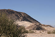
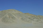
- Blowsand Hill, visible from Highway 78 and located between Ranger Station Road and Main Street
- Devils Slide, a small sand dune adjacent to a steep rocky hill
- Shell Reef
- Gas Dome
- Pumpkin Patch
A map of these locations as well as numerous other trails is available at the ranger station.
See also
- Anza Borrego Desert State Park
- Borrego Springs, CaliforniaBorrego Springs, CaliforniaBorrego Springs is a census-designated place in San Diego County, California. The population was 3,429 at the 2010 census, up from 2,535 at the 2000 census. Many residents are seasonal while others remain year round...
- Salton SeaSalton SeaThe Salton Sea is a shallow, saline, endorheic rift lake located directly on the San Andreas Fault, predominantly in California's Imperial Valley. The lake occupies the lowest elevations of the Salton Sink in the Colorado Desert of Imperial and Riverside counties in Southern California. Like Death...
- Westmorland, CaliforniaWestmorland, CaliforniaWestmorland is a city in Imperial County, California. Westmorland is located southwest of Calipatria, The population was 2,225 at the 2010 census, up from 2,131 at the 2000 census...