

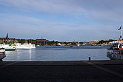
Nybroviken
Encyclopedia
Bay
A bay is an area of water mostly surrounded by land. Bays generally have calmer waters than the surrounding sea, due to the surrounding land blocking some waves and often reducing winds. Bays also exist as an inlet in a lake or pond. A large bay may be called a gulf, a sea, a sound, or a bight...
in central Stockholm
Stockholm
Stockholm is the capital and the largest city of Sweden and constitutes the most populated urban area in Scandinavia. Stockholm is the most populous city in Sweden, with a population of 851,155 in the municipality , 1.37 million in the urban area , and around 2.1 million in the metropolitan area...
, Sweden
Sweden
Sweden , officially the Kingdom of Sweden , is a Nordic country on the Scandinavian Peninsula in Northern Europe. Sweden borders with Norway and Finland and is connected to Denmark by a bridge-tunnel across the Öresund....
.
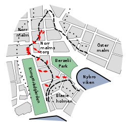
Nybroviken separates the city district Östermalm from the peninsula Blasieholmen. North of the bay is Berzelii Park
Berzelii Park
Berzelii Park is a small park in central Stockholm, Sweden, located next to Nybroplan and Norrmalmstorg. Berzelii Park is also the location of Chinateatern and the restaurant Berns Salonger.- History :- 19th century :...
and Norrmalmstorg
Norrmalmstorg
Norrmalmstorg is a square in central Stockholm. The square connects shopping streets Hamngatan and Biblioteksgatan and is the starting point for tram travellers with the Djurgården line...
. To the south Nybroviken connects to the bay Ladugårdslandsviken. Facing both these bays are the quays of Strandvägen
Strandvägen
Strandvägen is a boulevard on Östermalm in central Stockholm, Sweden. Completed just in time for the Stockholm World's Fair 1897, it quickly became known as one of the most prestigious addresses in town....
and Nybrokajen.
The name stems from the historical bridge Ladugårdslandsbron ("Barn's Land's Bridge"), also known as Nybro
Nybro
Nybro is a city and the seat of Nybro Municipality, Kalmar County, Sweden with 12,598 inhabitants in 2005.-Overview:The name Nybro literally means New Bridge. It was founded as a market town in the 19th century, but rapidly transformed into an industrial town. In 1865 the town became a municipality...
, which once stretched across the bay to connect to Nybrogatan
Nybrogatan
Nybrogatan is a street in the borough of Östermalm in central Stockholm, Sweden. Approximately one kilometre in length, it stretches north from Nybroplan to Valhallavägen....
. Today, Nybroviken is a frequently used departure point for ferries of various sizes bound for Djurgården and the Stockholm Archipelago
Stockholm archipelago
The Stockholm archipelago is the largest archipelago of Sweden, and one of the largest archipelagos of the Baltic Sea.-Geography:The archipelago extends from Stockholm roughly 60 kilometers to the east...
.
History
Stureplan
Stureplan is a high-end public square in central Stockholm, between Norrmalm and Östermalm. The square connects the major streets Kungsgatan, Birger Jarlsgatan and Sturegatan...
. Two water courses then emptied into the bay: Träskrännilen ("The Swamp Rill"), a strait which connected the bay to the historical lake Träsket ("The Swamp") along the southern part of present-day Birger Jarlsgatan
Birger Jarlsgatan
Birger Jarlsgatan is one of the longest streets in central Stockholm, Sweden. The street forms the border between Östermalm and the two neighbouring districts Norrmalm and Vasastaden....
. It was seven metres wide and marked the border between the city districts Norrmalm and Östermalm. Archaeological excavations in the 20th century unveiled ships and landing bridges under the present streets — today located more than 500 metres (1.600 feet) from the waterfront. Both the strait and the lake were made history by land filling around 1880. The second water course was the strait Näckströmmen ("The Neck
Nix
The Neck/Nixie are shapeshifting water spirits who usually appear in human form. The spirit has appeared in the myths and legends of all Germanic peoples in Europe....
Stream") which separated Blasieholmen (at the time an island) from the mainland north of it. In the mid-17th century the strait was 20 metres wide in average and 10 metres at its narrowest. The bridge Näckebro stretched across it. Within a century it was consumed by land filling.
Maps from the 18th century name the innermost part of the bay Packartorgsviken or Packartorgssjön ("Packer's Square's Bay/Lake") after the precursor of Norrmalmstorg
Norrmalmstorg
Norrmalmstorg is a square in central Stockholm. The square connects shopping streets Hamngatan and Biblioteksgatan and is the starting point for tram travellers with the Djurgården line...
square. Land fillings and garbage gradually transformed it to standing water with the surrounding quays littered with filth. A map from 1780 shows a single usable landing bridge remained in the bay at that time. In 1816, City Architect Carl Christopher Gjörwell was commissioned to redesign the quays of the bay, plans however only partly completed. Packartorgsviken became gradually smaller and swampier, and was colloquially called Katthavet ("The Cat Sea"), with Katt alluding to something small and false (i.e. a water body of insignificant size).
Fathomless to today's Stockholmers, Katthavet remained a popular spot for angling and pleasure rowing — truly an odd hobby as the filthy bay was also used for cleaning clothes. Not even the cholera pandemic of 1834
Second cholera pandemic
The second cholera pandemic also known as the Asiatic Cholera Pandemic was a Cholera pandemic from 1829-1849.-History:This pandemic began, like the first, with outbreaks along the Ganges River delta. From there the disease spread along trade routes to cover most of India. By 1828 the disease had...
, which caused the death of 4.000 Stockholmers, resulted in any sanitary actions from the city authorities. By the end of that decade, however, the 25th anniversary of King Charles XIV's arrival to Stockholm resulted in plans for a new bridge across the bay. On royal request, the bay north of the bridge was replaced by land filling, and the bridge thus transformed into a quay. The bridge was designed by Fredrik August Lidströmer
Fredrik August Lidströmer
Fredrik August Lidströmer , son of Jonas Lidströmer. Swedish architect, artist and marine officer and Stockholm's City architect. Grown up in the naval city of Karlskrona and came to Stockholm to help his father with construction of the Obelisk at Slottsbacken adjacent to the royal palace, and then...
, approved by His Majesty in 1837, and works, begun in 1838, were completed in 1849. In 1852 the work to transform the new open space into the present park was begun, and as the statue of Jöns Jacob Berzelius was produced by the Academy of Sciences
Royal Swedish Academy of Sciences
The Royal Swedish Academy of Sciences or Kungliga Vetenskapsakademien is one of the Royal Academies of Sweden. The Academy is an independent, non-governmental scientific organization which acts to promote the sciences, primarily the natural sciences and mathematics.The Academy was founded on 2...
, the park got its present name, Berzelii Park
Berzelii Park
Berzelii Park is a small park in central Stockholm, Sweden, located next to Nybroplan and Norrmalmstorg. Berzelii Park is also the location of Chinateatern and the restaurant Berns Salonger.- History :- 19th century :...
.
A decision by the city council in 1864 to replace the entire bay with landfills resulted in popular protests led by August Blanche
August Blanche
August Blanche was a Swedish journalist, novelist, and a Socialist statesman.August Theodor Blanche was born in Stockholm, Sweden, the illegitimate child of a servant girl and a priest. His mother eventually married Johan Jacob Blanck, a blacksmith and the boy took his stepfather's name...
, and in 1867 the council backed out, instead proposing a 395 metres long quay to be built. A statue of John Ericsson
John Ericsson
John Ericsson was a Swedish-American inventor and mechanical engineer, as was his brother Nils Ericson. He was born at Långbanshyttan in Värmland, Sweden, but primarily came to be active in England and the United States...
by John Börjeson
John Börjeson
Johan Laurentius Helenus Börjeson was a Swedish sculptor. Börjeson studied in Rome and Paris. He was a professor at Royal Swedish Academy of Arts in Stockholm 1886-1907.-References:*...
was inaugurated on the quay in 1875. In 1987, part of the quay was renamed in honour of the diplomat Raoul Wallenberg
Raoul Wallenberg
Raoul Wallenberg was a Swedish businessman, diplomat and humanitarian. He is widely celebrated for his successful efforts to rescue thousands of Jews in Nazi-occupied Hungary from the Holocaust, during the later stages of World War II...
.