

Nová Sedlica
Encyclopedia
Slovakia
The Slovak Republic is a landlocked state in Central Europe. It has a population of over five million and an area of about . Slovakia is bordered by the Czech Republic and Austria to the west, Poland to the north, Ukraine to the east and Hungary to the south...
(the most eastern point is the Kremenec Mountain), in Snina District
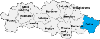
Snina District
Snina District is a district inthe Prešov Region of eastern Slovakia.Until 1918, the district was part of the Hungarian county of Zemplín.-Municipalities:*Belá nad Cirochou*Brezovec*Čukalovce*Dlhé nad Cirochou*Dúbrava*Hostovice...
in the Prešov Region
Prešov Region
The Prešov Region is one of the eight Slovak administrative regions. It consists of 13 districts.-Geography:It is located in north-eastern Slovakia and has an area of 8,975 km². The region has diverse types of landscapes occurring in Slovakia, but mostly highlands and hilly lands dominate the...
of north-eastern Slovakia
Slovakia
The Slovak Republic is a landlocked state in Central Europe. It has a population of over five million and an area of about . Slovakia is bordered by the Czech Republic and Austria to the west, Poland to the north, Ukraine to the east and Hungary to the south...
.
Village, situated in the buffer zone of the Poloniny National Park
Poloniny National Park
Poloniny National Park is a national park in north eastern Slovakia at the Polish and Ukrainian borders, in the Bukovské vrchy mountain range, which belongs to the Eastern Carpathians. It was created on 1 October 1997 with a protected area of 298.05 km² and a buffer zone of 109.73 km²...
, offers easy access to most of National Park's hiking trails. Stuzica, a component of the Primeval Beech Forests of the Carpathians
Primeval Beech Forests of the Carpathians
Primeval Beech Forests of the Carpathians and the Ancient Beech Forests of Germany is a transnational composite nature site. The Primeval Beech Forests of the Carpathians include 10 separate massifs located along the long axis from the Rakhiv mountains and Chornohora ridge in Ukraine over the...
UNESCO World Heritage Site is also close to the village.
(
In historical records the village was first mentioned in 1630. The municipality lies at an altitude of 421 metres and covers an area of 32.806 km². It has a population of about 340 people. The closest town is Snina
Snina
Snina is a town in Slovakia located at the confluence of the Cirocha river and the small river Pčolinka in the valley between the Beskydy foothills and the mountain of Vihorlat. It is the closest town with rail and bus connections to the Poloniny National Park.-History:The oldest written records...
, 43 km away.
The name of the town means a new settlement.