

Northern Outfall Sewer
Encyclopedia
The Northern Outfall Sewer (NOS) is a major gravity sewer
which runs from Wick Lane in Hackney to Beckton
Sewage Works in east London (east of Stratford
); most of it was designed by Joseph Bazalgette
after an outbreak of cholera
in 1853 and "The Big Stink
" of 1858.
Prior to this work, central London's drains were built primarily to cope with rain water, and the growing use of flush toilet
s frequently meant that they became overloaded, flushing mud, shingle, sewage and industrial effluent into the River Thames
. Bazalgette's London sewerage system
project included the construction of intercepting sewers north and south of the Thames; the Southern Outfall Sewer
network diverts flows away from the Thames south of the river.
In total five interceptor sewers were constructed north of the Thames; three were built by Bazalgette, two were added 30 years later:
The flows from the two low level sewers are raised by some 40 feet (12.2 m) into the Northern Outfall Sewer at Abbey Mills Pumping Station to join the flows from the High and Middle Level sewers.
The remaining sections of the NOS carry the sewage from Abbey Mills to the treatment plant at Beckton. The creation of the NOS was a massive undertaking, and involved the construction of both huge embankments and several bridges.
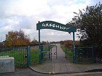 Today, the eastern end of the Northern Outfall Sewer, running some 4.5 miles (7.2 km) from Wick Lane, Bow to Beckton has been landscaped to form a public footpath/cycleway called The Greenway with access points along its length. Signage is made from old sewerage pipes.
Sanitary sewer
A sanitary sewer is a separate underground carriage system specifically for transporting sewage from houses and commercial buildings to treatment or disposal. Sanitary sewers serving industrial areas also carry industrial wastewater...
which runs from Wick Lane in Hackney to Beckton
Beckton
Beckton is part of the London Borough of Newham, England, located east of Charing Cross.Its boundaries are the A13 trunk road to the north, Barking Creek to the east, the Royal Docks to the south, and Prince Regent Lane to the west. The area around Prince Regent Lane is also known as Custom House...
Sewage Works in east London (east of Stratford
Stratford, London
Stratford is a place in the London Borough of Newham, England. It is located east northeast of Charing Cross and is one of the major centres identified in the London Plan. It was historically an agrarian settlement in the ancient parish of West Ham, which transformed into an industrial suburb...
); most of it was designed by Joseph Bazalgette
Joseph Bazalgette
Sir Joseph William Bazalgette, CB was an English civil engineer of the 19th century. As chief engineer of London's Metropolitan Board of Works his major achievement was the creation of a sewer network for central London which was instrumental in relieving the city from cholera epidemics, while...
after an outbreak of cholera
Cholera
Cholera is an infection of the small intestine that is caused by the bacterium Vibrio cholerae. The main symptoms are profuse watery diarrhea and vomiting. Transmission occurs primarily by drinking or eating water or food that has been contaminated by the diarrhea of an infected person or the feces...
in 1853 and "The Big Stink
The Great Stink
The Great Stink, or the Big Stink, was a time in the summer of 1858 during which the smell of untreated human waste was very strong in central London.-Water supply and sanitation prior to the Great Stink:...
" of 1858.
Prior to this work, central London's drains were built primarily to cope with rain water, and the growing use of flush toilet
Flush toilet
A flush toilet is a toilet that disposes of human waste by using water to flush it through a drainpipe to another location. Flushing mechanisms are found more often on western toilets , but many squat toilets also are made for automated flushing...
s frequently meant that they became overloaded, flushing mud, shingle, sewage and industrial effluent into the River Thames
River Thames
The River Thames flows through southern England. It is the longest river entirely in England and the second longest in the United Kingdom. While it is best known because its lower reaches flow through central London, the river flows alongside several other towns and cities, including Oxford,...
. Bazalgette's London sewerage system
London sewerage system
The London sewerage system is part of the water infrastructure serving London. The modern system was developed during the late 19th century, and as London has grown the system has been expanded.-History:...
project included the construction of intercepting sewers north and south of the Thames; the Southern Outfall Sewer
Southern Outfall Sewer
The Southern Outfall Sewer is a major sewer taking sewage from the southern area of central London to Crossness in south-east London. Flows from three interceptory sewers combine at Deptford and then run under Greenwich, Woolwich, Plumstead and across Erith marshes...
network diverts flows away from the Thames south of the river.
In total five interceptor sewers were constructed north of the Thames; three were built by Bazalgette, two were added 30 years later:
- The northernmost (High Level Sewer) begins on HampsteadHampsteadHampstead is an area of London, England, north-west of Charing Cross. Part of the London Borough of Camden in Inner London, it is known for its intellectual, liberal, artistic, musical and literary associations and for Hampstead Heath, a large, hilly expanse of parkland...
Hill and is routed past Kentish TownKentish TownKentish Town is an area of north west London, England in the London Borough of Camden.-History:The most widely accepted explanation of the name of Kentish Town is that it derived from 'Ken-ditch' meaning the 'bed of a waterway'...
and Stoke NewingtonStoke NewingtonStoke Newington is a district in the London Borough of Hackney. It is north-east of Charing Cross.-Boundaries:In modern terms, Stoke Newington can be roughly defined by the N16 postcode area . Its southern boundary with Dalston is quite ill-defined too...
and under Victoria ParkVictoria Park, East LondonVictoria Park is 86.18 hectares of open space that stretches out across part of the East End of London, England bordering parts of Bethnal Green, Hackney, and Bow, such as along Old Ford Road, London E3 and Victoria Park Road E9. The park is entirely within the London Borough of Tower Hamlets...
to the start of the Northern Outfall Sewer at Wick Lane. - Two middle level sewers serve parts of central London and also join the Northern Outfall Sewer at Wick lane:
- One begins close to Kilburn and runs along Edgware Road, Euston RoadEuston RoadEuston Road is an important thoroughfare in central London, England, and forms part of the A501. It is part of the New Road from Paddington to Islington, and was opened as part of the New Road in 1756...
and past King's Cross, through IslingtonIslingtonIslington is a neighbourhood in Greater London, England and forms the central district of the London Borough of Islington. It is a district of Inner London, spanning from Islington High Street to Highbury Fields, encompassing the area around the busy Upper Street...
to Wick Lane. - The other runs from Kensal GreenKensal GreenKensal Green, also referred to as Kensal Rise is an area of London, England. It is located on the southern edge of the London Borough of Brent and borders the City of Westminster to the East and the Royal Borough of Kensington and Chelsea to the South....
, under BayswaterBayswaterBayswater is an area of west London in the City of Westminster and the Royal Borough of Kensington and Chelsea to the west . It is a built-up district located 3 miles west-north-west of Charing Cross, bordering the north of Hyde Park over Kensington Gardens and having a population density of...
and along Oxford StreetOxford StreetOxford Street is a major thoroughfare in the City of Westminster in the West End of London, United Kingdom. It is Europe's busiest shopping street, as well as its most dense, and currently has approximately 300 shops. The street was formerly part of the London-Oxford road which began at Newgate,...
, then via ClerkenwellClerkenwellClerkenwell is an area of central London in the London Borough of Islington. From 1900 to 1965 it was part of the Metropolitan Borough of Finsbury. The well after which it was named was rediscovered in 1924. The watchmaking and watch repairing trades were once of great importance...
and Bethnal GreenBethnal GreenBethnal Green is a district of the East End of London, England and part of the London Borough of Tower Hamlets, with the far northern parts falling within the London Borough of Hackney. Located northeast of Charing Cross, it was historically an agrarian hamlet in the ancient parish of Stepney,...
to Wick lane.
- One begins close to Kilburn and runs along Edgware Road, Euston Road
- Two low-level sewers stretch from west London:
- One starts from near Ravenscourt ParkRavenscourt ParkThis article is about the public park. For the London Underground station of this name see Ravenscourt Park tube station and for the Electoral Division see Ravenscourt Park ...
, passes under HammersmithHammersmithHammersmith is an urban centre in the London Borough of Hammersmith and Fulham in west London, England, in the United Kingdom, approximately five miles west of Charing Cross on the north bank of the River Thames...
and KensingtonKensingtonKensington is a district of west and central London, England within the Royal Borough of Kensington and Chelsea. An affluent and densely-populated area, its commercial heart is Kensington High Street, and it contains the well-known museum district of South Kensington.To the north, Kensington is...
, PiccadillyPiccadillyPiccadilly is a major street in central London, running from Hyde Park Corner in the west to Piccadilly Circus in the east. It is completely within the city of Westminster. The street is part of the A4 road, London's second most important western artery. St...
, the StrandStrand, LondonStrand is a street in the City of Westminster, London, England. The street is just over three-quarters of a mile long. It currently starts at Trafalgar Square and runs east to join Fleet Street at Temple Bar, which marks the boundary of the City of London at this point, though its historical length...
, AldwychAldwychAldwych is a place and road in the City of Westminster in London, England.-Description:Aldwych, the road, is a crescent, connected to the Strand at both ends. At its centre, it meets the Kingsway...
, the City and AldgateAldgateAldgate was the eastern most gateway through London Wall leading from the City of London to Whitechapel and the east end of London. Aldgate gives its name to a ward of the City...
to Abbey Mills. - The second begins in Hammersmith, crosses under FulhamFulhamFulham is an area of southwest London in the London Borough of Hammersmith and Fulham, SW6 located south west of Charing Cross. It lies on the left bank of the Thames, between Putney and Chelsea. The area is identified in the London Plan as one of 35 major centres in Greater London...
and then runs along the Kings RoadKings RoadKing's Road or Kings Road, known popularly as The King's Road or The KR, is a major, well-known street stretching through Chelsea and Fulham, both in west London, England...
and Cheyne WalkCheyne WalkCheyne Walk , is a historic street in Chelsea, the Royal Borough of Kensington and Chelsea. It takes its name from William Lord Cheyne who owned the manor of Chelsea until 1712. Most of the houses were built in the early 18th century. Before the construction in the 19th century of the busy...
from where it becomes an integral part of the Thames EmbankmentThames EmbankmentThe Thames Embankment is a major feat of 19th century civil engineering designed to reclaim marshy land next to the River Thames in central London. It consists of the Victoria and Chelsea Embankment....
. Western pumping station near Chelsea BridgeChelsea BridgeChelsea Bridge is a bridge over the River Thames in west London, connecting Chelsea on the north bank to Battersea on the south bank. There have been two Chelsea Bridges, on the site of what was an ancient ford....
helps maintain the necessary gravity flow, taking sewage on along MillbankMillbankMillbank is an area of central London in the City of Westminster. Millbank is located by the River Thames, east of Pimlico and south of Westminster...
, the Victoria EmbankmentVictoria EmbankmentThe Victoria Embankment is part of the Thames Embankment, a road and river walk along the north bank of the River Thames in London. Victoria Embankment extends from the City of Westminster into the City of London.-Construction:...
and Tower HillTower HillTower Hill is an elevated spot northwest of the Tower of London, just outside the limits of the City of London, in the London Borough of Tower Hamlets. Formerly it was part of the Tower Liberty under the direct administrative control of Tower...
, then north-east under WhitechapelWhitechapelWhitechapel is a built-up inner city district in the London Borough of Tower Hamlets, London, England. It is located east of Charing Cross and roughly bounded by the Bishopsgate thoroughfare on the west, Fashion Street on the north, Brady Street and Cavell Street on the east and The Highway on the...
, StepneyStepneyStepney is a district of the London Borough of Tower Hamlets in London's East End that grew out of a medieval village around St Dunstan's church and the 15th century ribbon development of Mile End Road...
and BowBow, LondonBow is an area of London, England, United Kingdom in the London Borough of Tower Hamlets. It is a built-up, mostly residential district located east of Charing Cross, and is a part of the East End.-Bridges at Bowe:...
to Abbey Mills.
- One starts from near Ravenscourt Park
The flows from the two low level sewers are raised by some 40 feet (12.2 m) into the Northern Outfall Sewer at Abbey Mills Pumping Station to join the flows from the High and Middle Level sewers.
The remaining sections of the NOS carry the sewage from Abbey Mills to the treatment plant at Beckton. The creation of the NOS was a massive undertaking, and involved the construction of both huge embankments and several bridges.