
North Beach, Western Australia
Encyclopedia
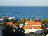
North Beach is a northern coastal suburb of Perth
, the capital city of Western Australia
, and is located 16 kilometres (10 mi) from Perth's central business district
via Mitchell Freeway
and Reid Highway
. Its Local Government Area
is the City of Stirling.
The area originally formed part of the Hamersley Estate, which also included the suburbs now known as Carine, North Beach and Hamersley. These areas were owned by the Hamersley family, who arrived from Europe to settle in the Swan River Colony in 1837 and built a summer home, called "The Castle" in 1865, where their large family as well as the Perth elite congregated for summer holidays. "The Castle" was later converted into the Castle Hotel, but after 75 years was demolished and subdivided in 1998.
Originally set aside as a timber reserve, the area was first settled by pastoralists in the 1860s. It served as a stopping point and watering hole along the Coastal Stock Route between Dongara
(near Geraldton) and Fremantle
. Cattle drovers frequented the area and Afghan camel drivers were a common sight after the opening of the goldfields in the 1890s - the area also served as a quarantine area for camels entering the colony. A number of orchards operated in the area - the only evidence which remains today is an old olive tree on Hope Street.
The only way into the area at this time was via a wooden block road built by convicts (later Wanneroo Road
) and then along a limestone track to North Beach, although numerous tracks through the bushland were developed as time progressed.
During World War I
, the Australian 10th Light Horse Regiment were stationed at Mount Flora on coast-watch duties, and kept their horses at a yard at the corner of modern-day Hope and Hale Streets. During the Great Depression
, the area around the intersection of West Coast Drive and North Beach Road was a 'tent city
' which housed "many unfortunate people 'on hard times'".
After World War II, the area developed rapidly, and in 1954, the Postal District of North Beach was approved. By 1961, nearly all of the existing suburb had been built and settled.
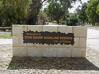
Bushland Reserve is a bushland reserve occupying about half of the land area of the suburbs of Watermans Bay and North Beach. The precise origin of the name is unknown, but the earliest known use of the name was on a lease application by J.H.Okely of Wanneroo in 1868.
In 1987, the State Government set aside 96 hectares as an A-class reserve, and funding from the Bicentennial
Commemorative Program and assistance from local organisations facilitated the establishment of the Star Swamp Heritage Trail within the reserve.
to the east, an imprecise line near Lynn Street to the south and West Coast Drive and the ocean to the west. Star Swamp represents one-third of the suburb's area. Reid Highway empties into North Beach's eastern border, and is the suburb's outlet to the Mitchell Freeway and the city.
At the ABS
2001 census, North Beach had a population of 2,949 people living in 1,270 dwellings, with a median age of 42 years (among the oldest in the northern suburbs). Residential styles in North Beach include a mix of holiday dwellings from before and after World War II, some former workers' houses, and modern dwellings.
is nearby.
Star Swamp Bushland Reserve is accessible from the eastern edge of the suburb (Hope Street and Groat Street).
On the northern boundary is the Mount Flora Regional Museum, built in 1936 as a water tower at the highest point of the suburb to provide scheme water to surrounding areas. It was phased out of service in the 1970s, and converted to a museum and lookout in May 1986. It now details the region's history, and is home to the North Suburban Historical Society.
423 bus route between Warwick
and Stirling
, operated by Path Transit
.
In 1925, the North Beach Bus Company was started by Alf Lehman with crimson charabanc
s. It was taken over by the James family in 1928, in an era when REO
buses drove over plank road
s through the wetlands between modern-day Tuart Hill
and North Beach. The company was taken over by the MTT
on 30 September 1961.
at both federal and state elections
. However, voters in this suburb lean more towards progressive parties than in similar-demographic Watermans Bay and Marmion
.
Perth, Western Australia
Perth is the capital and largest city of the Australian state of Western Australia and the fourth most populous city in Australia. The Perth metropolitan area has an estimated population of almost 1,700,000....
, the capital city of Western Australia
Western Australia
Western Australia is a state of Australia, occupying the entire western third of the Australian continent. It is bounded by the Indian Ocean to the north and west, the Great Australian Bight and Indian Ocean to the south, the Northern Territory to the north-east and South Australia to the south-east...
, and is located 16 kilometres (10 mi) from Perth's central business district
Central business district
A central business district is the commercial and often geographic heart of a city. In North America this part of a city is commonly referred to as "downtown" or "city center"...
via Mitchell Freeway
Mitchell Freeway
Mitchell Freeway is a long freeway in Perth, Western Australia, linking Perth's central business district with its outer northern suburbs. It is allocated Route 2 for its entire length and is named after former state Premier and Governor Sir James Mitchell....
and Reid Highway
Reid Highway
Reid Highway is a major arterial highway in Perth, Western Australia. It is allocated Route 3, and runs between Marmion Avenue, North Beach, and West Swan Road, West Swan, a distance of...
. Its Local Government Area
Local Government Areas of Western Australia
The Australian state of Western Australia is divided into 141 local government areas...
is the City of Stirling.
History
The name North Beach began as a descriptive name, derived from the suburb being at the time the most northerly of Perth's beaches. It was assigned in 1888 when surveyor Charles Crossland referred to the pastoral leases of Samuel Richard Hamersley as his "north beach coastal run".The area originally formed part of the Hamersley Estate, which also included the suburbs now known as Carine, North Beach and Hamersley. These areas were owned by the Hamersley family, who arrived from Europe to settle in the Swan River Colony in 1837 and built a summer home, called "The Castle" in 1865, where their large family as well as the Perth elite congregated for summer holidays. "The Castle" was later converted into the Castle Hotel, but after 75 years was demolished and subdivided in 1998.
Originally set aside as a timber reserve, the area was first settled by pastoralists in the 1860s. It served as a stopping point and watering hole along the Coastal Stock Route between Dongara
Dongara, Western Australia
Dongara is a town located 351 km north-northwest of Perth on the Brand Highway. The town is located at the mouth of the Irwin River. In recent years the area has been marketed as the 'Rock lobster capital of Australia'....
(near Geraldton) and Fremantle
Fremantle
Freemantle is a suburb of Southampton in England.Fremantle or Freemantle may also refer to:- Places :* Fremantle, the port city to the capital Perth, Western Australia...
. Cattle drovers frequented the area and Afghan camel drivers were a common sight after the opening of the goldfields in the 1890s - the area also served as a quarantine area for camels entering the colony. A number of orchards operated in the area - the only evidence which remains today is an old olive tree on Hope Street.
The only way into the area at this time was via a wooden block road built by convicts (later Wanneroo Road
Wanneroo Road
Wanneroo Road is an important arterial road in Perth, Australia. It is about 75 kilometres long. It links Perth with the City of Wanneroo, and the Towns of Yanchep and Lancelin...
) and then along a limestone track to North Beach, although numerous tracks through the bushland were developed as time progressed.
During World War I
World War I
World War I , which was predominantly called the World War or the Great War from its occurrence until 1939, and the First World War or World War I thereafter, was a major war centred in Europe that began on 28 July 1914 and lasted until 11 November 1918...
, the Australian 10th Light Horse Regiment were stationed at Mount Flora on coast-watch duties, and kept their horses at a yard at the corner of modern-day Hope and Hale Streets. During the Great Depression
Great Depression
The Great Depression was a severe worldwide economic depression in the decade preceding World War II. The timing of the Great Depression varied across nations, but in most countries it started in about 1929 and lasted until the late 1930s or early 1940s...
, the area around the intersection of West Coast Drive and North Beach Road was a 'tent city
Tent City
A tent city is a temporary housing facility made using tents. Informal tent cities may be set up without authorization by homeless people or protesters. As well, state governments or military organizations set up tent cities to house refugees, evacuees, or soldiers...
' which housed "many unfortunate people 'on hard times'".
After World War II, the area developed rapidly, and in 1954, the Postal District of North Beach was approved. By 1961, nearly all of the existing suburb had been built and settled.
Star Swamp
Star SwampStar Swamp
Star Swamp Bushland Reserve is a bushland reserve occupying about half of the land area of the suburbs of Watermans Bay and North Beach in the northern suburbs of Perth, Western Australia...
Bushland Reserve is a bushland reserve occupying about half of the land area of the suburbs of Watermans Bay and North Beach. The precise origin of the name is unknown, but the earliest known use of the name was on a lease application by J.H.Okely of Wanneroo in 1868.
In 1987, the State Government set aside 96 hectares as an A-class reserve, and funding from the Bicentennial
Australian Bicentenary
The bicentenary of Australia was celebrated in 1970 on the 200th anniversary of Captain James Cook landing and claiming the land, and again in 1988 to celebrate 200 years of permanent European settlement.-1970:...
Commemorative Program and assistance from local organisations facilitated the establishment of the Star Swamp Heritage Trail within the reserve.
Geography
North Beach is bounded by Hale Street to the north, Marmion AvenueMarmion Avenue
Marmion Avenue is a major arterial road in Perth, Western Australia, designated State Route 71.It runs through the northern coastal suburbs of Perth from the end of West Coast Highway in Trigg and Karrinyup, to the outer northern suburb of Yanchep...
to the east, an imprecise line near Lynn Street to the south and West Coast Drive and the ocean to the west. Star Swamp represents one-third of the suburb's area. Reid Highway empties into North Beach's eastern border, and is the suburb's outlet to the Mitchell Freeway and the city.
At the ABS
Australian Bureau of Statistics
The Australian Bureau of Statistics is Australia's national statistical agency. It was created as the Commonwealth Bureau of Census and Statistics on 8 December 1905, when the Census and Statistics Act 1905 was given Royal assent. It had its beginnings in section 51 of the Constitution of Australia...
2001 census, North Beach had a population of 2,949 people living in 1,270 dwellings, with a median age of 42 years (among the oldest in the northern suburbs). Residential styles in North Beach include a mix of holiday dwellings from before and after World War II, some former workers' houses, and modern dwellings.
Facilities
North Beach is a residential suburb, with small shopping areas on the coast and at Flora Terrace and Castle Street which offer basic commercial services. Nearby Karrinyup Shopping Centre provides other services. North Beach features a tennis club (synthetic and hard surfaces) near Our Lady of Grace. The suburb contains North Beach Primary School and the private Our Lady of Grace school - Carine Senior High SchoolCarine Senior High School
Carine Senior High School is a co-educational state secondary school, located in the suburb of Carine, approximately 15 km north-west of Perth.-History:...
is nearby.
Star Swamp Bushland Reserve is accessible from the eastern edge of the suburb (Hope Street and Groat Street).
On the northern boundary is the Mount Flora Regional Museum, built in 1936 as a water tower at the highest point of the suburb to provide scheme water to surrounding areas. It was phased out of service in the 1970s, and converted to a museum and lookout in May 1986. It now details the region's history, and is home to the North Suburban Historical Society.
Transport
North Beach is served by the TransperthTransperth
Transperth is the brand name of the public transport system in Perth, Western Australia. It is operated by the Public Transport Authority.-History:...
423 bus route between Warwick
Warwick railway station, Perth
Warwick railway station is a Transperth train and bus interchange located north-northwest of Perth railway station in Western Australia, on the Joondalup Line.-History:...
and Stirling
Stirling railway station, Perth
Stirling railway station is a Transperth train and bus interchange located northwest of Perth railway station in Western Australia, on the Joondalup Line.-History:...
, operated by Path Transit
Path Transit
Path Transit is a transport company operating 320 buses in Perth, Australia since 1996.It has depots in :* Bayswater* MalagaPath Transit also provides rental of vehicles for private functions.-Vehicles:...
.
In 1925, the North Beach Bus Company was started by Alf Lehman with crimson charabanc
Charabanc
A charabanc or "char-à-banc" is a type of horse-drawn vehicle or early motor coach, usually open-topped, common in Britain during the early part of the 20th century. It was especially popular for sight-seeing or "works outings" to the country or the seaside, organised by businesses once a year...
s. It was taken over by the James family in 1928, in an era when REO
REO Motor Car Company
The REO Motor Car Company was a Lansing, Michigan based company that produced automobiles and trucks from 1905 to 1975. At one point the company also manufactured buses on its truck platforms.REO was initiated by Ransom E. Olds during August 1904...
buses drove over plank road
Plank road
A plank road or puncheon is a dirt path or road covered with a series of planks, similar to the wooden sidewalks one would see in a Western movie. Plank roads were very popular in Ontario, the U.S. Northeast and U.S. Midwest in the first half of the 19th century...
s through the wetlands between modern-day Tuart Hill
Tuart Hill, Western Australia
Tuart Hill is a suburb of Perth, Western Australia.Tuart Hill is named after the Tuart tree that once grew extensively throughout the area, especially around Dog Swamp...
and North Beach. The company was taken over by the MTT
Transperth
Transperth is the brand name of the public transport system in Perth, Western Australia. It is operated by the Public Transport Authority.-History:...
on 30 September 1961.
Politics
North Beach is a reasonably affluent suburb with a large elderly population. It consistently supports the Liberal PartyLiberal Party of Australia
The Liberal Party of Australia is an Australian political party.Founded a year after the 1943 federal election to replace the United Australia Party, the centre-right Liberal Party typically competes with the centre-left Australian Labor Party for political office...
at both federal and state elections
Parliament of Western Australia
The Parliament of Western Australia consists of the Legislative Council and the Legislative Assembly . The Parliament sits at Parliament House in Harvest Terrace, Perth....
. However, voters in this suburb lean more towards progressive parties than in similar-demographic Watermans Bay and Marmion
Marmion, Western Australia
Marmion is a northern coastal suburb of Perth, the capital city of Western Australia. Its Local Government Area is the City of Joondalup.-History:...
.
External links
The source of this article is wikipedia, the free encyclopedia. The text of this article is licensed under the GFDL.
|