

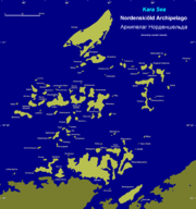
Nordenskiöld Archipelago
Encyclopedia
Kara Sea
The Kara Sea is part of the Arctic Ocean north of Siberia. It is separated from the Barents Sea to the west by the Kara Strait and Novaya Zemlya, and the Laptev Sea to the east by the Severnaya Zemlya....
. Its eastern limit lies 120 km (74.6 mi) west of the Taymyr Peninsula
Taymyr Peninsula
The Taymyr Peninsula is a peninsula in the Far North of Russia, in the Siberian Federal District, that forms the northernmost part of mainland Eurasia and Asia...
.
There are about 90 cold, windswept and desolate islands in this archipelago. These are mainly formed by igneous rock
Igneous rock
Igneous rock is one of the three main rock types, the others being sedimentary and metamorphic rock. Igneous rock is formed through the cooling and solidification of magma or lava...
s and are covered with tundra
Tundra
In physical geography, tundra is a biome where the tree growth is hindered by low temperatures and short growing seasons. The term tundra comes through Russian тундра from the Kildin Sami word tūndâr "uplands," "treeless mountain tract." There are three types of tundra: Arctic tundra, alpine...
vegetation. Except for two weather stations, one which was permanent in Russky Island between 1935 and 1999 and a temporary one in Tyrtov Island (Tyrtova) (1940-1975) there is no habitation in any island of the archipelago.
The Nordenskiöld Archipelago stretches for almost 100 km (62.1 mi) from west to east and about 90 km (55.9 mi) from north to south along the Kara Sea
Kara Sea
The Kara Sea is part of the Arctic Ocean north of Siberia. It is separated from the Barents Sea to the west by the Kara Strait and Novaya Zemlya, and the Laptev Sea to the east by the Severnaya Zemlya....
coastal region, off the Siberia
Siberia
Siberia is an extensive region constituting almost all of Northern Asia. Comprising the central and eastern portion of the Russian Federation, it was part of the Soviet Union from its beginning, as its predecessor states, the Tsardom of Russia and the Russian Empire, conquered it during the 16th...
n shores, where there are large coastal islands (Taymyr Island
Taymyr Island
Taymyr Island, Russian: Остров Таймыр , is a large island in the coast of the Kara Sea. Its length is and its average width about . This island is located west of the Taymyr Gulf in an area of skerries right off the western coast of the Taymyr Peninsula...
, Nansena Island
Nansen Island (Kara Sea)
Nansen Island , is a long and narrow island in the coast of the Kara Sea. Its length is and its average width about . This island is located in an area of skerries right off the western coast of the Taymyr Peninsula...
).
The Nordenskiöld Archipelago has been divided for geographical purposes into groups. The main groups are from west to east:
- Tsivolko Islands (острова Циволько; Ostrova Tsivolko) 76°44′N 94°38′E is the westernmost group.
- Vilkitsky Islands (острова Вилькицкого, also Dzhekman Islands) 76°25′N 95°15′E. The highest point of the archipelago (107 m) is located in Chabak Island, one of the Vilkitsky Islands.
- Pakhtusov Islands (острова Пахтусова; Ostrova Pakhtusova) 76°37′N 95°53′E.
- Litke Islands (острова Литке; Ostrova Litke), 76°49′N 96°36′E. This group includes Russky IslandRussky Island (Kara Sea)Russky Island , also spelt Russkyy and Russkiy, meaning "Russian Island", is an island in the Kara Sea. It is located in the Litke Islands subgroup of the Nordenskiöld Archipelago. With and area of 309 km², Russky is the biggest island in the whole archipelago...
(остров Русский; Ostrov Russkiy) 77°03′N 96°09′E. Located at the archipelago's northern end, this is the largest island of the Nordenskiöld group.
- Vostyochnyye Islands (Восточные острова; Vostyochnyye Ostrova, Eastern Islands), latitude 76° 38' N and longitude 97° 30' E. This group includes the Kolomeitsev IslandsKolomeitsev IslandsThe Kolomeytseva Islands is a group of two small islands, part of the Nordenskjold Archipelago in the Kara Sea coastal region, off the coast of Siberia...
(острова Коломейцева; Ostrova Kolomeytseva) 76°56′N 97°48′E.
The climate in the Nordenskiöld Archipelago is Arctic and severe. The sea surrounding the multitude of island groups is covered with fast ice in the winter and it is obstructed by pack ice even in the summer, which lasts only about two months in a normal year.
This island group belongs to the Krasnoyarsk Krai
Krasnoyarsk Krai
Krasnoyarsk Krai is a federal subject of Russia . It is the second largest federal subject after the Sakha Republic, and Russia's largest krai, occupying an area of , which is 13% of the country's total territory. The administrative center of the krai is the city of Krasnoyarsk...
administrative division of Russia
Russia
Russia or , officially known as both Russia and the Russian Federation , is a country in northern Eurasia. It is a federal semi-presidential republic, comprising 83 federal subjects...
.
History
This archipelago was first reported in 1740 by Nikifor Chekin, who accompanied Semion ChelyuskinSemion Chelyuskin
Semyon Ivanovich Chelyuskin was a Russian polar explorer and naval officer.Chelyuskin graduated from the Navigation School in Moscow. He first became a deputy navigator while serving in the Baltic Fleet and later promoted to navigator . Chelyuskin was chosen for the Second Kamchatka Expedition,...
in the Great Northern Expedition. Many years later it was named after arctic explorer Adolf Erik Nordenskiöld
Adolf Erik Nordenskiöld
Freiherr Nils Adolf Erik Nordenskiöld , also known as A. E. Nordenskioeld was a Finnish baron, geologist, mineralogist and arctic explorer of Finnish-Swedish origin. He was a member of the prominent Finland-Swedish Nordenskiöld family of scientists...
by Norwegian polar explorer Fridtjof Nansen
Fridtjof Nansen
Fridtjof Wedel-Jarlsberg Nansen was a Norwegian explorer, scientist, diplomat, humanitarian and Nobel Peace Prize laureate. In his youth a champion skier and ice skater, he led the team that made the first crossing of the Greenland interior in 1888, and won international fame after reaching a...
in his maps of the northern coasts and seas of Siberia.
In 1893, when Fridtjof Nansen
Fridtjof Nansen
Fridtjof Wedel-Jarlsberg Nansen was a Norwegian explorer, scientist, diplomat, humanitarian and Nobel Peace Prize laureate. In his youth a champion skier and ice skater, he led the team that made the first crossing of the Greenland interior in 1888, and won international fame after reaching a...
's Fram
Fram
Fram is a ship that was used in expeditions of the Arctic and Antarctic regions by the Norwegian explorers Fridtjof Nansen, Otto Sverdrup, Oscar Wisting, and Roald Amundsen between 1893 and 1912...
was near the Nordenskjold Archipelago, it got stuck in dead water
Dead water
Dead water is the nautical term for a strange phenomenon which can occur when a layer of fresh or brackish water rests on top of denser salt water, without the two layers mixing. A ship powered by direct thrust under the waterline , traveling in such conditions may be hard to maneuver or can even...
. This is a strange phenomenon that typically occurs in fjord
Fjord
Geologically, a fjord is a long, narrow inlet with steep sides or cliffs, created in a valley carved by glacial activity.-Formation:A fjord is formed when a glacier cuts a U-shaped valley by abrasion of the surrounding bedrock. Glacial melting is accompanied by rebound of Earth's crust as the ice...
s, as glaciers melt and a form a shallow layer of freshwater ice over salty water.
This is how Nansen described the phenomenon:
Towards the end of August 1893, when the "Fram" was off the Taymyr Peninsula, near the Nordenskiöld Archipelago, "dead water" was encountered. This is a peculiar phenomenon, which occurs where a surface layer of fresh water rests upon the salt water of the sea. It manifests itself in the form of larger or smaller ripples or waves stretching across the wake, the one behind the other, arising sometimes as far forward as almost midships. When caught in dead water, "Fram" appeared to be held back, as if by some mysterious force, and she did not always answer the helm. In calm weather, with a light cargo, "Fram" was capable of 6 to 7 knots. When in dead water she was unable to make 1.5 knots. We made loops in our course turned sometimes right around, tried all sorts of antics to get clear of it, but to very little purpose.
In 1900 the islands of the Nordenskiöld Archipelago were explored and mapped with accuracy by Captain Fyodor Andreyevich Matisen
Fyodor Andreyevich Matisen
Fyodor Andreyevich Matisen was a lieutenant of the Russian Imperial Navy, hydrographer, and explorer.-The Russian Polar Expedition :...
during the Russian Polar Expedition (1900 – 1903). This venture was led by Baron Eduard Von Toll on behalf of the Imperial Russian Academy of Sciences
Russian Academy of Sciences
The Russian Academy of Sciences consists of the national academy of Russia and a network of scientific research institutes from across the Russian Federation as well as auxiliary scientific and social units like libraries, publishers and hospitals....
aboard ship Zarya
Zarya
Zarya , also known as the Functional Cargo Block or FGB , was the first module of the International Space Station to be launched. The FGB provided electrical power, storage, propulsion, and guidance to the ISS during the initial stage of assembly...
. Toll sent Matisen to make a survey of the archipelago in the early spring while the Zarya was wintering close to Taymyr Island
Taymyr Island
Taymyr Island, Russian: Остров Таймыр , is a large island in the coast of the Kara Sea. Its length is and its average width about . This island is located west of the Taymyr Gulf in an area of skerries right off the western coast of the Taymyr Peninsula...
. Most islands of the Nordenskiöld Archipelago were charted and named during this effort. Matisen crisscrossed the whole vast frozen area on dogsled
Dog sled
A dog sled is a sled pulled by one or more sled dogs used to travel over ice and through snow. Numerous types of sleds are used, depending on their function. They can be used for dog sled racing.-History:...
twice. He divided the archipelago into four of the five main groups mentioned above and named more than forty islands.
Like Nansen, Eduard Toll observed that it was difficult to navigate through the archipelago on account of the ice.
After the Russian Revolution, the archipelago was explored in the 1930s by a Soviet expedition on the icebreaker Sedov
Icebreaker Sedov
The Sedov was a Soviet ice-breaker fitted with steam engines. She was originally the Newfoundland sealing steamer Beothic and was renamed after Russian Captain and Polar explorer Georgy Yakovlevich Sedov....
.
In 1937 the Arctic Institute
Arctic and Antarctic Research Institute
The Arctic and Antarctic Research Institute, or AARI is the oldest and largest Russian research institute in the field of comprehensive studies of Arctic and Antarctica...
of the USSR organized an expedition on ship Toros. The purpose of this expedition was to explore the Nordenskiöld Archipelago and to thoroughly investigate the Northern Sea Route
Northern Sea Route
The Northern Sea Route is a shipping lane officially defined by Russian legislation from the Atlantic Ocean to the Pacific Ocean specifically running along the Russian Arctic coast from Murmansk on the Barents Sea, along Siberia, to the Bering Strait and Far East. The entire route lies in Arctic...
in the Kara Sea
Kara Sea
The Kara Sea is part of the Arctic Ocean north of Siberia. It is separated from the Barents Sea to the west by the Kara Strait and Novaya Zemlya, and the Laptev Sea to the east by the Severnaya Zemlya....
. The Toros overwintered in Ledyanaya Bay on Bonevi Island west of Taymyr Island
Taymyr Island
Taymyr Island, Russian: Остров Таймыр , is a large island in the coast of the Kara Sea. Its length is and its average width about . This island is located west of the Taymyr Gulf in an area of skerries right off the western coast of the Taymyr Peninsula...
and sailed back to Archangelsk during the summer thaw after having explored many Kara Sea islands.
On the 25th August 1942, during Operation Wunderland
Operation Wunderland
Operation Wunderland was a large-scale operation undertaken in summer 1942 by the Kriegsmarine during World War II in the waters of the Northern Sea Route close to the Arctic Ocean...
, Kriegsmarine
Kriegsmarine
The Kriegsmarine was the name of the German Navy during the Nazi regime . It superseded the Kaiserliche Marine of World War I and the post-war Reichsmarine. The Kriegsmarine was one of three official branches of the Wehrmacht, the unified armed forces of Nazi Germany.The Kriegsmarine grew rapidly...
cruiser Admiral Scheer fell upon the Russian icebreaker Sibiryakov
Icebreaker Sibiryakov
The icebreaker Sibiryakov was a Soviet ship which was active in the Russian Arctic during the 1930s. She was built in 1909 in Glasgow and was originally the Newfoundland sealing steamer Bellaventure. After being purchased by Russia in 1916, she was renamed the Sibiryakov...
]] (under the command of Captain Kacharev) off the northwest coast of Russky Island
Russky Island (Kara Sea)
Russky Island , also spelt Russkyy and Russkiy, meaning "Russian Island", is an island in the Kara Sea. It is located in the Litke Islands subgroup of the Nordenskiöld Archipelago. With and area of 309 km², Russky is the biggest island in the whole archipelago...
at the northern end of the Nordenskiöld Archipelago. The Sibiryakov resisted but was sunk by the German warship. Then Admiral Scheer headed southwest in order to attack the Soviet military installations at Dikson.
Since May 1993 the Nordenskiöld Archipelago is part of the Great Arctic State Nature Reserve
Great Arctic State Nature Reserve
The Great Arctic State Nature Reserve is a nature reserve in Krasnoyarsk Krai, Russia...
, the largest nature reserve
Nature reserve
A nature reserve is a protected area of importance for wildlife, flora, fauna or features of geological or other special interest, which is reserved and managed for conservation and to provide special opportunities for study or research...
of Russia. The Arctic station at Russky Island was closed in 1999.
See also
- Fyodor Andreyevich MatisenFyodor Andreyevich MatisenFyodor Andreyevich Matisen was a lieutenant of the Russian Imperial Navy, hydrographer, and explorer.-The Russian Polar Expedition :...
- Icebreaker SedovIcebreaker SedovThe Sedov was a Soviet ice-breaker fitted with steam engines. She was originally the Newfoundland sealing steamer Beothic and was renamed after Russian Captain and Polar explorer Georgy Yakovlevich Sedov....
- Kara SeaKara SeaThe Kara Sea is part of the Arctic Ocean north of Siberia. It is separated from the Barents Sea to the west by the Kara Strait and Novaya Zemlya, and the Laptev Sea to the east by the Severnaya Zemlya....
- List of islands of Russia
- Nansen's Fram expeditionNansen's Fram expeditionNansen's Fram expedition, 1893–1896, was an attempt by the Norwegian explorer Fridtjof Nansen to reach the geographical North Pole by harnessing the natural east–west current of the Arctic Ocean...
- Operation WunderlandOperation WunderlandOperation Wunderland was a large-scale operation undertaken in summer 1942 by the Kriegsmarine during World War II in the waters of the Northern Sea Route close to the Arctic Ocean...
External links
- All locations
- Valerian AlbanovValerian AlbanovValerian Ivanovich Albanov was a Russian navigator, best known for being one of only two survivors of the ill-fated Brusilov expedition of 1912.-Biography:...
, In the Land of the White Death, 2001. Contains pictures of Fridtjof Nansen's early Arctic maps. - On fast ice conditions near the Nordenskjold Archipelago
- Nature Reserve
- Consideration on geographic peculiarities on waterways of the Northern Sea Route
- Polar Exploration