

Nolin River
Encyclopedia
Tributary
A tributary or affluent is a stream or river that flows into a main stem river or a lake. A tributary does not flow directly into a sea or ocean...
of the Green River
Green River (Kentucky)
The Green River is a tributary of the Ohio River that rises in Lincoln County in south-central Kentucky. Tributaries of the Green River include the Barren River, the Nolin River, the Pond River and the Rough River...
in central Kentucky
Kentucky
The Commonwealth of Kentucky is a state located in the East Central United States of America. As classified by the United States Census Bureau, Kentucky is a Southern state, more specifically in the East South Central region. Kentucky is one of four U.S. states constituted as a commonwealth...
in the United States
United States
The United States of America is a federal constitutional republic comprising fifty states and a federal district...
. Via the Green and Ohio
Ohio River
The Ohio River is the largest tributary, by volume, of the Mississippi River. At the confluence, the Ohio is even bigger than the Mississippi and, thus, is hydrologically the main stream of the whole river system, including the Allegheny River further upstream...
rivers, it is part of the watershed
Drainage basin
A drainage basin is an extent or an area of land where surface water from rain and melting snow or ice converges to a single point, usually the exit of the basin, where the waters join another waterbody, such as a river, lake, reservoir, estuary, wetland, sea, or ocean...
of the Mississippi River
Mississippi River
The Mississippi River is the largest river system in North America. Flowing entirely in the United States, this river rises in western Minnesota and meanders slowly southwards for to the Mississippi River Delta at the Gulf of Mexico. With its many tributaries, the Mississippi's watershed drains...
. The United States Board on Geographic Names
United States Board on Geographic Names
The United States Board on Geographic Names is a United States federal body whose purpose is to establish and maintain uniform usage of geographic names throughout the U.S. government.-Overview:...
settled on "Nolin River" as the stream's name in 1933.
The Nolin River is formed in western LaRue County
LaRue County, Kentucky
LaRue County is a county located in the U.S. state of Kentucky. It is included in the Elizabethtown, Kentucky, Metropolitan Statistical Area. As of 2000, the population was 13,373. Its county seat is Hodgenville...
by the confluence of its short North and South Forks, both of which flow for their entire lengths in Larue County; the North Fork flows past Hodgenville
Hodgenville, Kentucky
Hodgenville is a city in and the county seat of LaRue County, Kentucky, United States. It sits along the North Fork of the Nolin River. The population was 2,874 at the 2000 census...
. The Nolin then flows generally southwestwardly through or along the boundaries of Hardin
Hardin County, Kentucky
As of the census of 2000, there were 94,174 people, 34,497 households, and 25,355 families residing in the county. The population density was . There were 37,673 housing units at an average density of...
, Grayson
Grayson County, Kentucky
Grayson County is a county located in the U.S. state of Kentucky. It was formed in 1810. As of 2000, the population was 24,053. Its county seat is Leitchfield. The county is named for William Grayson , a Revolutionary War colonel and a prominent Virginia political figure...
, Hart
Hart County, Kentucky
Hart County is a county located in the U.S. state — or, more correctly, "Commonwealth" — of Kentucky. It was formed in 1819. , the population was 17,445. Its county seat is Munfordville. The county is named for Captain Nathaniel G. S. Hart, a Kentucky militia officer in the War of 1812...
and Edmonson
Edmonson County, Kentucky
Edmonson County is a county located in the U.S. state of Kentucky. It was formed in 1826. As of 2007, the population was 11,978. It is included in the Bowling Green Metropolitan Statistical Area. Its county seat is Brownsville...
counties. It joins the Green River in the western part of Mammoth Cave National Park
Mammoth Cave National Park
Mammoth Cave National Park is a U.S. National Park in central Kentucky, encompassing portions of Mammoth Cave, the longest cave system known in the world. The official name of the system is the Mammoth-Flint Ridge Cave System for the ridge under which the cave has formed. The park was established...
, about 2 miles (3 km) northeast of Brownsville
Brownsville, Kentucky
Brownsville is a city in and the county seat of Edmonson County, Kentucky, United States. The population is 1,000 at the 2000 census. It is included in the Bowling Green, Kentucky Metropolitan Statistical Area...
.
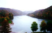
In Edmonson County, a U.S. Army Corps of Engineers dam
Dam
A dam is a barrier that impounds water or underground streams. Dams generally serve the primary purpose of retaining water, while other structures such as floodgates or levees are used to manage or prevent water flow into specific land regions. Hydropower and pumped-storage hydroelectricity are...
causes the river to form Nolin River Lake
Nolin River Lake
Nolin River Lake is a reservoir in Edmonson, Grayson, and Hart counties in Kentucky. It was impounded from the Nolin River by the United States Army Corps of Engineers in 1963. The Nolin River dam was authorized in 1938 as part of a flood control act...
.