

Nissaka-shuku
Encyclopedia
53 Stations of the Tokaido
The are the rest areas along the Tōkaidō, which was a coastal route that ran from Nihonbashi in Edo to Sanjō Ōhashi in Kyoto.-Stations of the Tōkaidō:...
of the Tōkaidō
Tokaido (road)
The ' was the most important of the Five Routes of the Edo period, connecting Edo to Kyoto in Japan. Unlike the inland and less heavily travelled Nakasendō, the Tōkaidō travelled along the sea coast of eastern Honshū, hence the route's name....
. It is located in what is now part of the city of Kakegawa
Kakegawa, Shizuoka
is a city in western Shizuoka Prefecture, Japan. As of 2010, the city had an estimated population of 117,858 and a population density of 444 persons per km². The total area was 265.63 km².-Geography:...
, Shizuoka Prefecture
Shizuoka Prefecture
is a prefecture of Japan located in the Chūbu region on Honshu island. The capital is the city of Shizuoka.- History :Shizuoka prefecture was formed from the former Tōtōmi, Suruga and Izu provinces.The area was the home of the first Tokugawa Shogun...
, Japan
Japan
Japan is an island nation in East Asia. Located in the Pacific Ocean, it lies to the east of the Sea of Japan, China, North Korea, South Korea and Russia, stretching from the Sea of Okhotsk in the north to the East China Sea and Taiwan in the south...
.
History
Nissaka-shuku was located at the western entrance to , regarded as one of the three difficult mountain passes along the Tōkaidō. At the western entrance of Nissaka-shuku is .Originally, various characters were used for Nissaka, including 入坂, 西坂 and 新坂, as it had been nothing more than a small town located between Kanaya-juku
Kanaya-juku
was the twenty-fourth of the fifty-three stations of the Tōkaidō. It is located in what is now part of Shimada, Shizuoka Prefecture, Japan. During the Edo period, it was the easternmost post station of Tōtōmi Province.-History:...
on the banks of the Ōi River
Oi River
The is a river in Shizuoka Prefecture, Japan.-Geography:The Ōi River flows from the Akaishi Mountains, the branch of the Japanese Southern Alps which form the border between Shizuoka, Nagano and Yamanashi prefectures. These mountains, with peaks ranging from 2000–3000 meters, are characterized by...
and Kakegawa-juku
Kakegawa-juku
was the twenty-sixth of the fifty-three stations of the Tōkaidō. It is located in the what is now the city of Kakegawa, Shizuoka Prefecture, Japan.-History:Kakegawa-juku was originally the castle town of Kakegawa Castle...
, a castle town that was an intersection along an old salt trading route. When Nissaka-shuku was established as part of the Tōkaidō at the start of the Edo period
Edo period
The , or , is a division of Japanese history which was ruled by the shoguns of the Tokugawa family, running from 1603 to 1868. The political entity of this period was the Tokugawa shogunate....
, the characters for its name officially became 日坂.
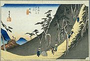
The classic ukiyoe print by Ando Hiroshige (Hoeido edition) from 1831-1834 depicts travellers on a steep road in forbidding dark mountains contemplating a large boulder in the road. The stone was a noted landmark on Tōkaidō called the "Night weeping stone". According to legend, the bandits attacked and murdered a pregnant woman on this spot. After she died, a passing priest heard the stone call out for him to rescue the surviving infant
The Tōkaidō Main Line
Tokaido Main Line
The is the busiest trunk line of the Japan Railways Group , connecting Tōkyō and Kōbe stations. It is long, not counting its many freight feeder lines around the major cities...
railroad, established during the Meiji period
Meiji period
The , also known as the Meiji era, is a Japanese era which extended from September 1868 through July 1912. This period represents the first half of the Empire of Japan.- Meiji Restoration and the emperor :...
, was built to avoid the difficult pass and, as a result, the fortunes of Nissaka-shuku began to fall. It began to prosper again when Route 1
Route 1 (Japan)
National Route 1 is a major highway on the island of Honshū in Japan. It connects Chūō, Tokyo in the Kantō region with the city of Osaka, Osaka Prefecture in the Kansai region, passing through the Chūbu region en route. It follows the old Tōkaidō westward from Tokyo to Kyoto, and the old Kyo Kaidō...
was rebuilt after World War II
World War II
World War II, or the Second World War , was a global conflict lasting from 1939 to 1945, involving most of the world's nations—including all of the great powers—eventually forming two opposing military alliances: the Allies and the Axis...
, with the new route running through Nissaka.
In 1955, the village of Nissaka in Ogasa District
Ogasa District, Shizuoka
was a rural district located in western Shizuoka, Japan.As of the end of 2003 , the district had an estimated population of 82,248 and a population density of 472.47 persons per km². Its total area was 174.08 km².-History:Ogasa District was on April 1, 1896 through the merger of former and...
merged with the neighboring city of Kakegawa.
Ekiden
The city of Kakegawa hosts the every year in April.Further reading
- Carey, Patrick. Rediscovering the Old Tokaido:In the Footsteps of Hiroshige. Global Books UK (2000). ISBN 1901903109
- Chiba, Reiko. Hiroshige's Tokaido in Prints and Poetry. Tuttle. (1982) ISBN 0804802467
- Taganau, Jilly. The Tokaido Road: Travelling and Representation in Edo and Meiji Japan. RoutledgeCurzon (2004). ISBN 0415310911