
Nighthawk, Washington
Encyclopedia
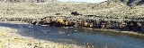
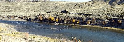
Nighthawk is an unincorporated
community on the Similkameen River
in Okanogan County, Washington state, USA. It was named for a nearby (and now-closed) mine. Nighthawk is a (mostly former) logging
area along Loomis-Oroville Highway west-northwest of Oroville, Washington
. Nighthawk also features a border crossing and is located along the Burlington Northern Railroad
. The town of Nighthawk used to be a booming mine town at the turn of the century with hotels and had a burlesque house but the population now is about 5 people.
The border crossing is usually known as "the Nighthawk crossing" on the Canadian side, though the official name of the Canadian-side locality is Chopaka
.
Unincorporated area
In law, an unincorporated area is a region of land that is not a part of any municipality.To "incorporate" in this context means to form a municipal corporation, a city, town, or village with its own government. An unincorporated community is usually not subject to or taxed by a municipal government...
community on the Similkameen River
Similkameen River
The Similkameen River runs through southern British Columbia, eventually discharging into the Okanogan River near Oroville, Washington in the United States. The river is approximately long, and its drainage basin is in area...
in Okanogan County, Washington state, USA. It was named for a nearby (and now-closed) mine. Nighthawk is a (mostly former) logging
Logging
Logging is the cutting, skidding, on-site processing, and loading of trees or logs onto trucks.In forestry, the term logging is sometimes used in a narrow sense concerning the logistics of moving wood from the stump to somewhere outside the forest, usually a sawmill or a lumber yard...
area along Loomis-Oroville Highway west-northwest of Oroville, Washington
Oroville, Washington
Oroville is a town in Okanogan County, Washington, United States. The population was 1,686 at the 2010 census.-Geography:Oroville is located at ....
. Nighthawk also features a border crossing and is located along the Burlington Northern Railroad
Burlington Northern Railroad
The Burlington Northern Railroad was a United States-based railroad company formed from a merger of four major U.S. railroads. Burlington Northern operated between 1970 and 1996....
. The town of Nighthawk used to be a booming mine town at the turn of the century with hotels and had a burlesque house but the population now is about 5 people.
The border crossing is usually known as "the Nighthawk crossing" on the Canadian side, though the official name of the Canadian-side locality is Chopaka
Chopaka, British Columbia
Chopaka is an unincorporated settlement near the US border on the west bank of the Similkameen River in the Southern Interior of British Columbia, Canada. Largely comprising two Indian Reserves, Chopaka IR No. 7 and Chopaka IR No. 8, the location was formerly listed as a railway station...
.