
Nieuwe Waterweg
Encyclopedia
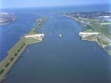
The Nieuwe Waterweg is a ship canal
in the Netherlands
from het Scheur (a branch of the Rhine-Meuse-Scheldt delta
) west of the town
of Maassluis
to the North Sea
at Hook of Holland. It is the artificial mouth of the river Rhine.
The Nieuwe Waterweg, which opened in 1872 and has a length of approximately 10 km, was constructed to keep the city and port of Rotterdam
accessible to seafaring vessels
as the natural Meuse-Rhine branches silted up. The Waterway is a busy shipping route since it is the primary access to one of the busiest ports in the world, the Europoort
of Rotterdam
. At the entrance to the sea, a flood protection system called Maeslantkering
has been installed (completed in 1997). There are no bridges or tunnels across the Nieuwe Waterweg.
In 1863, a law was passed which allowed for the provision of a new canal for large ocean-going ships from Rotterdam to the North Sea. Hydraulic engineer
Pieter Caland
was commissioned to design a canal cutting through the "Hook of Holland” and to extend the Mouth of Rhine to the sea. The designs for this were already done back in 1731 by Nicolaas Samuelsz Cruquius
but the implementation could no longer be postponed to prevent the decline of the harbour of Rotterdam.
Construction began on October 31, 1863. The first phase consisted of the expropriation of farm lands from Rozenburg
to Hoek van Holland.
During the second phase two dikes were built parallel to each other, which took 2 years. Caland proposed to extend the dikes 2 km into the sea to disrupt the coastal sea currents and decrease silt deposits in the shipping lane.
Upon the completion of the dikes, the third phase began by the digging of the actual waterway. This began on October 31, 1866, and was completed three years later. The large amounts of removed soil were in turn used to reinforce other dams and dikes.
The last phase consisted of the removal of the dam separating the new waterway from the sea and river. In 1872, the Nieuwe Waterweg was completed and Rotterdam was easily accessible.
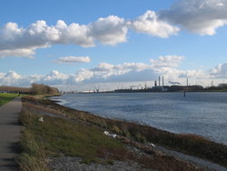
Because of the currents and erosion, the shipping lane has been widened somewhat. Yet because of the draft
of today's supertankers, it needs to be dredged constantly.
In 1997, the last part of the Delta Works
, the Maeslantkering
, was put in operation near the mouth of the Nieuwe Waterweg. This storm surge barrier protects Rotterdam against north westerly Beaufort
Force 10 to 12 storms.
Ship canal
A ship canal is a canal especially constructed to carry ocean-going ships, as opposed to barges. Ship canals can be enlarged barge canals, canalized or channelized rivers, or canals especially constructed from the start to accommodate ships....
in the Netherlands
Netherlands
The Netherlands is a constituent country of the Kingdom of the Netherlands, located mainly in North-West Europe and with several islands in the Caribbean. Mainland Netherlands borders the North Sea to the north and west, Belgium to the south, and Germany to the east, and shares maritime borders...
from het Scheur (a branch of the Rhine-Meuse-Scheldt delta
Rhine-Meuse-Scheldt delta
The Rhine–Meuse–Scheldt delta is a river delta in the Netherlands and Belgium formed by the confluence of the Rhine, the Meuse and the Scheldt rivers. The result is a multitude of islands, branches and branch names that may at first sight look bewildering, especially as a waterway that appears to...
) west of the town
Town
A town is a human settlement larger than a village but smaller than a city. The size a settlement must be in order to be called a "town" varies considerably in different parts of the world, so that, for example, many American "small towns" seem to British people to be no more than villages, while...
of Maassluis
Maassluis
Maassluis is a town in the western Netherlands, in the province of South Holland. The municipality had a population of 32,847 in 2004, and covers an area of 10.11 km² .It received city rights in 1811...
to the North Sea
North Sea
In the southwest, beyond the Straits of Dover, the North Sea becomes the English Channel connecting to the Atlantic Ocean. In the east, it connects to the Baltic Sea via the Skagerrak and Kattegat, narrow straits that separate Denmark from Norway and Sweden respectively...
at Hook of Holland. It is the artificial mouth of the river Rhine.
The Nieuwe Waterweg, which opened in 1872 and has a length of approximately 10 km, was constructed to keep the city and port of Rotterdam
Port of Rotterdam
The Port of Rotterdam is the largest port in Europe, located in the city of Rotterdam, Netherlands. From 1962 until 2004 it was the world's busiest port, now overtaken by first Shanghai and then Singapore...
accessible to seafaring vessels
Ship
Since the end of the age of sail a ship has been any large buoyant marine vessel. Ships are generally distinguished from boats based on size and cargo or passenger capacity. Ships are used on lakes, seas, and rivers for a variety of activities, such as the transport of people or goods, fishing,...
as the natural Meuse-Rhine branches silted up. The Waterway is a busy shipping route since it is the primary access to one of the busiest ports in the world, the Europoort
Europoort
Europoort is an area of the Port of Rotterdam and the adjoining industrial area in the Netherlands. Being situated at the mouth of the rivers Rhine and Meuse with the hinterland consisting of the Netherlands, Germany, Belgium and partly France, Europoort is by certain measurements the world's...
of Rotterdam
Rotterdam
Rotterdam is the second-largest city in the Netherlands and one of the largest ports in the world. Starting as a dam on the Rotte river, Rotterdam has grown into a major international commercial centre...
. At the entrance to the sea, a flood protection system called Maeslantkering
Maeslantkering
The Maeslantkering is a storm surge barrier in the Nieuwe Waterweg waterway located between the towns of Hoek van Holland and Maassluis, Netherlands, , which automatically closes when needed...
has been installed (completed in 1997). There are no bridges or tunnels across the Nieuwe Waterweg.
History
By the middle of the 19th century, Rotterdam was already one of the largest port cities in the world, mainly because of transshipment of goods from Germany to Great Britain. The increase in shipping traffic created a capacity problem: there were too many branches in the river delta, making the port difficult to reach.In 1863, a law was passed which allowed for the provision of a new canal for large ocean-going ships from Rotterdam to the North Sea. Hydraulic engineer
Hydraulic engineering
This article is about civil engineering. For the mechanical engineering discipline see Hydraulic machineryHydraulic engineering as a sub-discipline of civil engineering is concerned with the flow and conveyance of fluids, principally water and sewage. One feature of these systems is the extensive...
Pieter Caland
Pieter Caland
Pieter Caland was a Dutch civil engineer in the service of the Rijkswaterstaat. He devised the plan for the Nieuwe Waterweg and implemented it from 1866 to 1872....
was commissioned to design a canal cutting through the "Hook of Holland” and to extend the Mouth of Rhine to the sea. The designs for this were already done back in 1731 by Nicolaas Samuelsz Cruquius
Nicolaas Kruik
Nicolaas Kruik , also known as Nicolaes Krukius or most commonly by the Latinized Nicolaus Samuelis Cruquius, was a Dutch land surveyor, cartographer, astronomer and weatherman...
but the implementation could no longer be postponed to prevent the decline of the harbour of Rotterdam.
Construction began on October 31, 1863. The first phase consisted of the expropriation of farm lands from Rozenburg
Rozenburg
Rozenburg is a town and former municipality in the western Netherlands, in the province of South Holland. The municipality had a population of 13,173 in 2004, and covers an area of 6.50 km² . It was the second-smallest municipality in the Netherlands in area...
to Hoek van Holland.
During the second phase two dikes were built parallel to each other, which took 2 years. Caland proposed to extend the dikes 2 km into the sea to disrupt the coastal sea currents and decrease silt deposits in the shipping lane.
Upon the completion of the dikes, the third phase began by the digging of the actual waterway. This began on October 31, 1866, and was completed three years later. The large amounts of removed soil were in turn used to reinforce other dams and dikes.
The last phase consisted of the removal of the dam separating the new waterway from the sea and river. In 1872, the Nieuwe Waterweg was completed and Rotterdam was easily accessible.
Because of the currents and erosion, the shipping lane has been widened somewhat. Yet because of the draft
Draft (hull)
The draft of a ship's hull is the vertical distance between the waterline and the bottom of the hull , with the thickness of the hull included; in the case of not being included the draft outline would be obtained...
of today's supertankers, it needs to be dredged constantly.
In 1997, the last part of the Delta Works
Delta Works
The Delta Works is a series of construction projects in the southwest of the Netherlands to protect a large area of land around the Rhine-Meuse-Scheldt delta from the sea. The works consist of dams, sluices, locks, dikes, levees, and storm surge barriers...
, the Maeslantkering
Maeslantkering
The Maeslantkering is a storm surge barrier in the Nieuwe Waterweg waterway located between the towns of Hoek van Holland and Maassluis, Netherlands, , which automatically closes when needed...
, was put in operation near the mouth of the Nieuwe Waterweg. This storm surge barrier protects Rotterdam against north westerly Beaufort
Beaufort scale
The Beaufort Scale is an empirical measure that relates wind speed to observed conditions at sea or on land. Its full name is the Beaufort Wind Force Scale.-History:...
Force 10 to 12 storms.