
Newburn Bridge
Encyclopedia
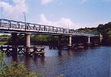
Newburn Bridge is a road bridge crossing the River Tyne
at Newburn
in Newcastle upon Tyne
, England
. It links Newburn, Walbottle
and Throckley
on the north side of the river with Ryton
, Stella
and Blaydon
on the south side. The bridge is the western most crossing of the Tyne in the county of Tyne and Wear
; the next crossing upstream, Wylam Bridge
, is in Northumberland
.
since Roman times
because it is the most eastern part of the Tyne that is easily fordable. There have also been numerous ferries
operated in the part of the river around Newburn. A bridge was finally built between 1892 and 1893. It was designed by Sandeman & Moncrieff of Newcastle and built by Head Wrightson of Thornaby-on-Tees
. It was opened on 21 May 1893. For the first 50 or so years of its use it was a toll bridge, until it was bought by Northumberland
in 1947. The toll house on the north east side of the bridge has since been demolished. The bridge used to have two lanes crossing it up until the 1960s. It has since had single road traffic because of the weight limit of 9 tonnes (8.9 LT), later raised to 10 tonnes (9.8 LT).
In 2007 the bridge was closed for a number of months for renovation and repainting.
River Tyne
The River Tyne is a river in North East England in Great Britain. It is formed by the confluence of two rivers: the North Tyne and the South Tyne. These two rivers converge at Warden Rock near Hexham in Northumberland at a place dubbed 'The Meeting of the Waters'.The North Tyne rises on the...
at Newburn
Newburn
Newburn is a semi rural village, parish, electoral ward and former urban district in western Tyne and Wear, North East England. Situated on the banks of the River Tyne, it is built rising up the valley from the river...
in Newcastle upon Tyne
Newcastle upon Tyne
Newcastle upon Tyne is a city and metropolitan borough of Tyne and Wear, in North East England. Historically a part of Northumberland, it is situated on the north bank of the River Tyne...
, England
England
England is a country that is part of the United Kingdom. It shares land borders with Scotland to the north and Wales to the west; the Irish Sea is to the north west, the Celtic Sea to the south west, with the North Sea to the east and the English Channel to the south separating it from continental...
. It links Newburn, Walbottle
Walbottle
Walbottle is a village in Tyne and Wear. It is a western suburb of Newcastle upon Tyne. The village name, recorded in 1176 as "Walbotl", is derived from the Old English botl on the Roman Wall...
and Throckley
Throckley
Throckley is a village, located approximately 11 km west of Newcastle upon Tyne, in North East England. Hadrian's Wall passes through the village, its course traced by the village's main road, Hexham Road....
on the north side of the river with Ryton
Ryton, Tyne and Wear
Ryton is a semi-rural small town near the western border of Tyne and Wear, England. Once an independent town in County Durham it became incorporated into the metropolitan county of Tyne and Wear and the Metropolitan Borough of Gateshead in 1974. It has a population of 15,742.- Location :Ryton lies...
, Stella
Stella park
Stella Park is a housing estate in Blaydon-on-Tyne, Tyne and Wear, England, located on the grounds of a mansion of the same name.-Stella Hall:...
and Blaydon
Blaydon
Blaydon-on-Tyne is a town in the North East of England in the Metropolitan Borough of Gateshead. The former urban district, however, extends much further, its fourteen and a half square miles constituting the largest administrative district, after Newcastle, on Tyneside...
on the south side. The bridge is the western most crossing of the Tyne in the county of Tyne and Wear
Tyne and Wear
Tyne and Wear is a metropolitan county in north east England around the mouths of the Rivers Tyne and Wear. It came into existence as a metropolitan county in 1974 after the passage of the Local Government Act 1972...
; the next crossing upstream, Wylam Bridge
Wylam Bridge
Wylam Bridge is a road bridge in Northumberland, England linking the residential area of North Wylam and neighbouring villages of Heddon-on-the-Wall, and Horsley with the railway station in South Wylam as well as west Gateshead, including the villages of Ryton and Crawcrook.- History :The River...
, is in Northumberland
Northumberland
Northumberland is the northernmost ceremonial county and a unitary district in North East England. For Eurostat purposes Northumberland is a NUTS 3 region and is one of three boroughs or unitary districts that comprise the "Northumberland and Tyne and Wear" NUTS 2 region...
.
History
This part of the river has been fordedFord (crossing)
A ford is a shallow place with good footing where a river or stream may be crossed by wading or in a vehicle. A ford is mostly a natural phenomenon, in contrast to a low water crossing, which is an artificial bridge that allows crossing a river or stream when water is low.The names of many towns...
since Roman times
Roman Empire
The Roman Empire was the post-Republican period of the ancient Roman civilization, characterised by an autocratic form of government and large territorial holdings in Europe and around the Mediterranean....
because it is the most eastern part of the Tyne that is easily fordable. There have also been numerous ferries
Ferry
A ferry is a form of transportation, usually a boat, but sometimes a ship, used to carry primarily passengers, and sometimes vehicles and cargo as well, across a body of water. Most ferries operate on regular, frequent, return services...
operated in the part of the river around Newburn. A bridge was finally built between 1892 and 1893. It was designed by Sandeman & Moncrieff of Newcastle and built by Head Wrightson of Thornaby-on-Tees
Thornaby-on-Tees
Thornaby-on-Tees is a town and civil parish within the Borough of Stockton-on-Tees, in the ceremonial county of North Yorkshire, England. It is on the south bank of the River Tees, three miles southeast of Stockton-on-Tees, and four miles southwest of Middlesbrough town centre and has a...
. It was opened on 21 May 1893. For the first 50 or so years of its use it was a toll bridge, until it was bought by Northumberland
Northumberland
Northumberland is the northernmost ceremonial county and a unitary district in North East England. For Eurostat purposes Northumberland is a NUTS 3 region and is one of three boroughs or unitary districts that comprise the "Northumberland and Tyne and Wear" NUTS 2 region...
in 1947. The toll house on the north east side of the bridge has since been demolished. The bridge used to have two lanes crossing it up until the 1960s. It has since had single road traffic because of the weight limit of 9 tonnes (8.9 LT), later raised to 10 tonnes (9.8 LT).
In 2007 the bridge was closed for a number of months for renovation and repainting.