
New York State Route 444
Encyclopedia
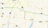
New York State Route 444 (NY 444) is a north–south state highway
in Ontario County, New York
, in the United States
. It serves as a connector between the overlapping routes of U.S. Route 20
, NY 5
, and NY 64
south of the village of Bloomfield
and NY 96
in the village of Victor
. NY 444 is a two-lane highway that passes through mostly rural areas of the county, with the exception of the immediate areas around Bloomfield and Victor. The highway passes the Ganondagan State Historic Site
south of Victor.
The portion of NY 444 south of Main Street in Bloomfield was originally designated as part of legislative Route 14 by the New York State Legislature in 1908. This unsigned highway
, which extended from Corning
to Rochester
, also included the portion of Main Street in Bloomfield between modern NY 64 and NY 444. Route 14 was realigned to bypass the then-village of Holcomb
to the south and west in 1921. The segment of pre-1921 Route 14 from NY 64 to US 20 was designated as New York State Route 20C ca. 1931. NY 20C was truncated on its western end to the junction of Main Street and Maple Avenue in 1990. The roads extending north from NY 20C's northern terminus to Victor—namely Elm Street and County Route 3—were acquired by the state of New York
on September 1, 1996, and these roads were combined with NY 20C on June 2, 1997, to create NY 444.
, NY 5
, and NY 64
in the Ontario County
town of East Bloomfield
. It heads north as a two-lane highway into the eastern portion of the village of Bloomfield
, where it becomes known as Maple Avenue. At the former "Four Corners" of Holcomb
—its intersection with Main Street—NY 444 changes names to Elm Street, a moniker it retains until it exits the village.
Back in the town of East Bloomfield, NY 444 becomes Victor–Bloomfield Road and follows a gently curving alignment through a rural, hilly portion of Ontario County. It crosses into the town of Victor
at an intersection with Cherry Street. North of this point, NY 444 takes on a linear north–south alignment as it heads toward the village of Victor
. At the hamlet of Boughton Hill, NY 444 passes the Ganondagan State Historic Site
. From here, NY 444 descends into a valley that is home to the village of Victor. Inside the village, the route becomes Maple Avenue and crosses the Ontario Central Railroad
by way of a grade crossing before ending at a junction with NY 96
in the center of the village.
extending from the city of Corning
in the Southern Tier
to the city of Rochester
near Lake Ontario
. In the vicinity of the Ontario County
villages of East Bloomfield and Holcomb
, Route 14 was routed on modern U.S. Route 20
, Maple Avenue, Main Street, and NY 64
. On March 1, 1921, Route 14 was realigned to bypass Holcomb to the south and west on what is now US 20, NY 5, and NY 64.
The segment of former Route 14 between the intersection of US 20 and Maple Avenue south of Holcomb and the junction of NY 64 and Main Street west of East Bloomfield was designated as NY 20C, a loop route
of US 20, ca. 1931. In 1990, the villages of East Bloomfield and Holcomb were consolidated to create the village of Bloomfield
. That same year, NY 20C was truncated to consist only of the portion of the route between the former "Four Corners" of Holcomb—the intersection of Main Street and Maple Avenue—and US 20. The former portion of NY 20C on Main Street is now maintained by the town of East Bloomfield and the village of Bloomfield; however, it is still defined in New York State Highway Law as a state highway
.
On September 1, 1996, the state of New York
assumed ownership and maintenance of Elm Street in Bloomfield and County Route 3, the continuation of Elm Street north of the Bloomfield village line to the Victor village
line, as part of a county-wide highway maintenance swap. Elm Street had previously been maintained by the village of Bloomfield while CR 3 was maintained by Ontario County. The newly acquired roadway between Bloomfield and Victor and the remaining piece of NY 20C were redesignated as NY 444 on June 2, 1997. The portion of NY 444 within the village of Victor is locally maintained.
State highway
State highway, state road or state route can refer to one of three related concepts, two of them related to a state or provincial government in a country that is divided into states or provinces :#A...
in Ontario County, New York
Ontario County, New York
As of the census of 2000, there were 100,224 people, 38,370 households, and 26,360 families residing in the county. The population density was 156 people per square mile . There were 42,647 housing units at an average density of 66 per square mile...
, in the United States
United States
The United States of America is a federal constitutional republic comprising fifty states and a federal district...
. It serves as a connector between the overlapping routes of U.S. Route 20
U.S. Route 20 in New York
U.S. Route 20 is a part of the U.S. Highway System that runs from Newport, Oregon, to Boston, Massachusetts. In the U.S. state of New York, US 20 extends from the Pennsylvania state line at Ripley to the Massachusetts state line in the Berkshire Mountains. US 20 is the longest...
, NY 5
New York State Route 5
New York State Route 5 is a state highway that extends for across the state of New York in the United States. It begins at the Pennsylvania state line in the Chautauqua County town of Ripley and passes through Buffalo, Syracuse, Utica, Schenectady, and several other smaller cities and...
, and NY 64
New York State Route 64
New York State Route 64 is a north–south state highway in the Finger Lakes region of New York in the United States. Its southern terminus is at an intersection with NY 21 in the hamlet of Bristol Springs within the town of South Bristol, Ontario County...
south of the village of Bloomfield
Bloomfield, New York
Bloomfield is a village in Ontario County, New York, United States. The population was 1,267 at the 2000 census.The Village of Bloomfield is in the Town of East Bloomfield and is west of Canandaigua, NY.- History :...
and NY 96
New York State Route 96
New York State Route 96 is a northwest–southeast state highway in the Finger Lakes region of New York in the United States. The southern terminus of the route is at an interchange with NY 17 in the Southern Tier village of Owego, Tioga County. Its northern terminus is at a junction with...
in the village of Victor
Victor (village), New York
Victor is a village located in within the Town of Victor in Ontario County, New York, USA. The population was 2,433 at the 2000 census.The Village of Victor is in the southeast part of the town and is southeast of the City of Rochester.- History :...
. NY 444 is a two-lane highway that passes through mostly rural areas of the county, with the exception of the immediate areas around Bloomfield and Victor. The highway passes the Ganondagan State Historic Site
Ganondagan State Historic Site
Ganondagan State Historic Site also known as Boughton Hill is a New York State Native American historic site in Ontario County, New York in the USA. The historic site is in the Town of Victor, southwest of the Village of Victor...
south of Victor.
The portion of NY 444 south of Main Street in Bloomfield was originally designated as part of legislative Route 14 by the New York State Legislature in 1908. This unsigned highway
Unsigned highway
An unsigned highway is a highway that has been assigned a route number, but does not bear conventional road markings that would normally be used to identify the route with that number...
, which extended from Corning
Corning (city), New York
Corning is a city in Steuben County, New York, United States, on the Chemung River. The population was 10,842 at the 2000 census. It is named for Erastus Corning, an Albany financier and railroad executive who was an investor in the company that developed the community.- Overview :The city of...
to Rochester
Rochester, New York
Rochester is a city in Monroe County, New York, south of Lake Ontario in the United States. Known as The World's Image Centre, it was also once known as The Flour City, and more recently as The Flower City...
, also included the portion of Main Street in Bloomfield between modern NY 64 and NY 444. Route 14 was realigned to bypass the then-village of Holcomb
Holcomb, New York
Holcomb was a village located on New York State Route 444 in the Town of East Bloomfield. In 1990, the village merged with the neighboring village of East Bloomfield to create a single village named Bloomfield...
to the south and west in 1921. The segment of pre-1921 Route 14 from NY 64 to US 20 was designated as New York State Route 20C ca. 1931. NY 20C was truncated on its western end to the junction of Main Street and Maple Avenue in 1990. The roads extending north from NY 20C's northern terminus to Victor—namely Elm Street and County Route 3—were acquired by the state of New York
New York
New York is a state in the Northeastern region of the United States. It is the nation's third most populous state. New York is bordered by New Jersey and Pennsylvania to the south, and by Connecticut, Massachusetts and Vermont to the east...
on September 1, 1996, and these roads were combined with NY 20C on June 2, 1997, to create NY 444.
Route description
NY 444 begins at an intersection with the overlapped routes of U.S. Route 20U.S. Route 20 in New York
U.S. Route 20 is a part of the U.S. Highway System that runs from Newport, Oregon, to Boston, Massachusetts. In the U.S. state of New York, US 20 extends from the Pennsylvania state line at Ripley to the Massachusetts state line in the Berkshire Mountains. US 20 is the longest...
, NY 5
New York State Route 5
New York State Route 5 is a state highway that extends for across the state of New York in the United States. It begins at the Pennsylvania state line in the Chautauqua County town of Ripley and passes through Buffalo, Syracuse, Utica, Schenectady, and several other smaller cities and...
, and NY 64
New York State Route 64
New York State Route 64 is a north–south state highway in the Finger Lakes region of New York in the United States. Its southern terminus is at an intersection with NY 21 in the hamlet of Bristol Springs within the town of South Bristol, Ontario County...
in the Ontario County
Ontario County, New York
As of the census of 2000, there were 100,224 people, 38,370 households, and 26,360 families residing in the county. The population density was 156 people per square mile . There were 42,647 housing units at an average density of 66 per square mile...
town of East Bloomfield
East Bloomfield, New York
East Bloomfield is a town in Ontario County, New York, United States. The population was 3,361 at the 2000 census.The Town of East Bloomfield is in the western part of the county, south of Rochester, NY.- History :...
. It heads north as a two-lane highway into the eastern portion of the village of Bloomfield
Bloomfield, New York
Bloomfield is a village in Ontario County, New York, United States. The population was 1,267 at the 2000 census.The Village of Bloomfield is in the Town of East Bloomfield and is west of Canandaigua, NY.- History :...
, where it becomes known as Maple Avenue. At the former "Four Corners" of Holcomb
Holcomb, New York
Holcomb was a village located on New York State Route 444 in the Town of East Bloomfield. In 1990, the village merged with the neighboring village of East Bloomfield to create a single village named Bloomfield...
—its intersection with Main Street—NY 444 changes names to Elm Street, a moniker it retains until it exits the village.
Back in the town of East Bloomfield, NY 444 becomes Victor–Bloomfield Road and follows a gently curving alignment through a rural, hilly portion of Ontario County. It crosses into the town of Victor
Victor (town), New York
Victor is a town in Ontario County, New York, USA. The population was 9,977 at the 2000 census. The town is named after Claudius Victor Boughton, a hero of the War of 1812.The Town of Victor contains a village, also called Victor...
at an intersection with Cherry Street. North of this point, NY 444 takes on a linear north–south alignment as it heads toward the village of Victor
Victor (village), New York
Victor is a village located in within the Town of Victor in Ontario County, New York, USA. The population was 2,433 at the 2000 census.The Village of Victor is in the southeast part of the town and is southeast of the City of Rochester.- History :...
. At the hamlet of Boughton Hill, NY 444 passes the Ganondagan State Historic Site
Ganondagan State Historic Site
Ganondagan State Historic Site also known as Boughton Hill is a New York State Native American historic site in Ontario County, New York in the USA. The historic site is in the Town of Victor, southwest of the Village of Victor...
. From here, NY 444 descends into a valley that is home to the village of Victor. Inside the village, the route becomes Maple Avenue and crosses the Ontario Central Railroad
Ontario Central Railroad
The Ontario Central Railroad is an American class III railroad company operating in Ontario County, New York. As of 2007, the ONCT has been under the ownership of the Finger Lakes Railway....
by way of a grade crossing before ending at a junction with NY 96
New York State Route 96
New York State Route 96 is a northwest–southeast state highway in the Finger Lakes region of New York in the United States. The southern terminus of the route is at an interchange with NY 17 in the Southern Tier village of Owego, Tioga County. Its northern terminus is at a junction with...
in the center of the village.
History
In 1908, the New York State Legislature created Route 14, an unsigned legislative routeLegislative route
In United States, a legislative route or legislative highway is a highway defined by laws passed in a state legislature. The numbering of such highways may or may not correspond to the numbers familiar to the public as part of the state, U.S. highway, and Interstate highway systems...
extending from the city of Corning
Corning (city), New York
Corning is a city in Steuben County, New York, United States, on the Chemung River. The population was 10,842 at the 2000 census. It is named for Erastus Corning, an Albany financier and railroad executive who was an investor in the company that developed the community.- Overview :The city of...
in the Southern Tier
Southern Tier
The Southern Tier is a geographical term that refers to the counties of New York State west of the Catskill Mountains along the northern border of Pennsylvania. It is a loosely defined term that generally includes the counties that border Pennsylvania west of Delaware County inclusive...
to the city of Rochester
Rochester, New York
Rochester is a city in Monroe County, New York, south of Lake Ontario in the United States. Known as The World's Image Centre, it was also once known as The Flour City, and more recently as The Flower City...
near Lake Ontario
Lake Ontario
Lake Ontario is one of the five Great Lakes of North America. It is bounded on the north and southwest by the Canadian province of Ontario, and on the south by the American state of New York. Ontario, Canada's most populous province, was named for the lake. In the Wyandot language, ontarío means...
. In the vicinity of the Ontario County
Ontario County, New York
As of the census of 2000, there were 100,224 people, 38,370 households, and 26,360 families residing in the county. The population density was 156 people per square mile . There were 42,647 housing units at an average density of 66 per square mile...
villages of East Bloomfield and Holcomb
Holcomb, New York
Holcomb was a village located on New York State Route 444 in the Town of East Bloomfield. In 1990, the village merged with the neighboring village of East Bloomfield to create a single village named Bloomfield...
, Route 14 was routed on modern U.S. Route 20
U.S. Route 20 in New York
U.S. Route 20 is a part of the U.S. Highway System that runs from Newport, Oregon, to Boston, Massachusetts. In the U.S. state of New York, US 20 extends from the Pennsylvania state line at Ripley to the Massachusetts state line in the Berkshire Mountains. US 20 is the longest...
, Maple Avenue, Main Street, and NY 64
New York State Route 64
New York State Route 64 is a north–south state highway in the Finger Lakes region of New York in the United States. Its southern terminus is at an intersection with NY 21 in the hamlet of Bristol Springs within the town of South Bristol, Ontario County...
. On March 1, 1921, Route 14 was realigned to bypass Holcomb to the south and west on what is now US 20, NY 5, and NY 64.
The segment of former Route 14 between the intersection of US 20 and Maple Avenue south of Holcomb and the junction of NY 64 and Main Street west of East Bloomfield was designated as NY 20C, a loop route
Loop route
A loop route is a highway or other major road that extends out from a typically longer, more important parents road to enter and circle a large city. A loop can function as a bypass for through traffic and also to service outlying suburbs....
of US 20, ca. 1931. In 1990, the villages of East Bloomfield and Holcomb were consolidated to create the village of Bloomfield
Bloomfield, New York
Bloomfield is a village in Ontario County, New York, United States. The population was 1,267 at the 2000 census.The Village of Bloomfield is in the Town of East Bloomfield and is west of Canandaigua, NY.- History :...
. That same year, NY 20C was truncated to consist only of the portion of the route between the former "Four Corners" of Holcomb—the intersection of Main Street and Maple Avenue—and US 20. The former portion of NY 20C on Main Street is now maintained by the town of East Bloomfield and the village of Bloomfield; however, it is still defined in New York State Highway Law as a state highway
State highway
State highway, state road or state route can refer to one of three related concepts, two of them related to a state or provincial government in a country that is divided into states or provinces :#A...
.
On September 1, 1996, the state of New York
New York
New York is a state in the Northeastern region of the United States. It is the nation's third most populous state. New York is bordered by New Jersey and Pennsylvania to the south, and by Connecticut, Massachusetts and Vermont to the east...
assumed ownership and maintenance of Elm Street in Bloomfield and County Route 3, the continuation of Elm Street north of the Bloomfield village line to the Victor village
Victor (village), New York
Victor is a village located in within the Town of Victor in Ontario County, New York, USA. The population was 2,433 at the 2000 census.The Village of Victor is in the southeast part of the town and is southeast of the City of Rochester.- History :...
line, as part of a county-wide highway maintenance swap. Elm Street had previously been maintained by the village of Bloomfield while CR 3 was maintained by Ontario County. The newly acquired roadway between Bloomfield and Victor and the remaining piece of NY 20C were redesignated as NY 444 on June 2, 1997. The portion of NY 444 within the village of Victor is locally maintained.