
New York State Route 439
Encyclopedia
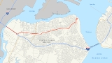
New York State Route 439 (NY 439) was an east–west state highway
on Staten Island
in New York
, United States
. The western terminus of the route was at the Goethals Bridge
, where it continued into New Jersey
as its Route 439. Its eastern terminus was at the Staten Island Ferry
terminal in the St. George
neighborhood. In between, NY 439 followed the Staten Island Expressway, Forest Avenue, Victory Boulevard, and Bay Street.
When NY 439 was assigned in 1949, it extended eastward into Brooklyn
by way of the Bay Ridge Ferry. In Brooklyn, the NY 439 designation continued along Bay Ridge Avenue (69th Street), 4th Avenue and Shore Road Drive to exit 1 of the Belt Parkway
, where it ended. In 1964, the Verrazano-Narrows Bridge
between Brooklyn and Staten Island was completed, resulting in the deactivation of the Bay Ridge Ferry and the truncation of NY 439 to the St. George ferry terminal. NY 439 ceased to exist entirely ca. 1968. Although the number was removed in New York, it had carried over to New Jersey and still exists today in Elizabeth, New Jersey
, as Route 439.
on Staten Island
, where it continued into New Jersey
as its Route 439. It headed southeast on what is now the Staten Island Expressway, passing through a largely undeveloped area of the island. At Forest Avenue, NY 439 turned to follow Forest Avenue eastward toward the neighborhood of Graniteville
. In Graniteville, the route intersected Richmond Avenue
, at the time part of NY 440
.
The route continued on, passing through densely populated areas of northern Staten Island as it proceeded eastward. In Silver Lake
, NY 439 intersected Victory Boulevard, here designated as NY 439A. At this point, NY 439A ended and NY 439 turned northeastward onto Victory Boulevard. The route remained on the roadway up to a junction with Bay Street near St. George
. Here, NY 439 curved northward to follow Bay Street north to St. George. The route ended at the Staten Island Ferry
terminal connecting Staten Island to Manhattan
.
and Staten Island
. The route began at the Goethals Bridge and, as it did for the entirety of its existence, followed Forest Avenue, Victory Boulevard, and Bay Street to the Staten Island Ferry
terminal in St. George
. At the time, it continued across The Narrows
to Brooklyn
by way of the Bay Ridge Ferry. Once in Brooklyn, it was routed on Bay Ridge Avenue (69th Street), 4th Avenue, and Shore Road Drive. The designation ended at exit 1 of the Belt Parkway
. NY 439 was also the planned number for the proposed North Shore Expressway across Staten Island's North Shore
; however, the highway was never constructed.
In 1964, the Verrazano-Narrows Bridge
linking Staten Island to Brooklyn was completed. As a result, the Bay Ridge Ferry was shut down and NY 439 was truncated to the St. George ferry terminal. The NY 439 designation was removed entirely ca. 1968. It was physically replaced by Interstate 278 in the vicinity of the Goethals Bridge and replaced in purpose by I-278 across the remainder of the island. Some signage for NY 439 remained posted on the road until the late 1970s.
 NY 439A was a spur of NY 439 on Staten Island
that connected NY 440
to NY 439 by way of Victory Boulevard. It was assigned in 1949 and removed ca. 1968.
State highway
State highway, state road or state route can refer to one of three related concepts, two of them related to a state or provincial government in a country that is divided into states or provinces :#A...
on Staten Island
Staten Island
Staten Island is a borough of New York City, New York, United States, located in the southwest part of the city. Staten Island is separated from New Jersey by the Arthur Kill and the Kill Van Kull, and from the rest of New York by New York Bay...
in New York
New York
New York is a state in the Northeastern region of the United States. It is the nation's third most populous state. New York is bordered by New Jersey and Pennsylvania to the south, and by Connecticut, Massachusetts and Vermont to the east...
, United States
United States
The United States of America is a federal constitutional republic comprising fifty states and a federal district...
. The western terminus of the route was at the Goethals Bridge
Goethals Bridge
The Goethals Bridge connects Elizabeth, New Jersey to Staten Island , near the Howland Hook Marine Terminal, Staten Island, New York over the Arthur Kill. Operated by the Port Authority of New York and New Jersey, the span was one of the first structures built by the authority...
, where it continued into New Jersey
New Jersey
New Jersey is a state in the Northeastern and Middle Atlantic regions of the United States. , its population was 8,791,894. It is bordered on the north and east by the state of New York, on the southeast and south by the Atlantic Ocean, on the west by Pennsylvania and on the southwest by Delaware...
as its Route 439. Its eastern terminus was at the Staten Island Ferry
Staten Island Ferry
The Staten Island Ferry is a passenger ferry service operated by the New York City Department of Transportation that runs between the boroughs of Manhattan and Staten Island.-Overview:...
terminal in the St. George
St. George, Staten Island
St. George is a neighborhood on the northeastern tip of Staten Island in New York City, where the Kill Van Kull enters Upper New York Bay. It is the most densely developed neighborhood on Staten Island, and the location of the administrative center for the borough and for the coterminous Richmond...
neighborhood. In between, NY 439 followed the Staten Island Expressway, Forest Avenue, Victory Boulevard, and Bay Street.
When NY 439 was assigned in 1949, it extended eastward into Brooklyn
Brooklyn
Brooklyn is the most populous of New York City's five boroughs, with nearly 2.6 million residents, and the second-largest in area. Since 1896, Brooklyn has had the same boundaries as Kings County, which is now the most populous county in New York State and the second-most densely populated...
by way of the Bay Ridge Ferry. In Brooklyn, the NY 439 designation continued along Bay Ridge Avenue (69th Street), 4th Avenue and Shore Road Drive to exit 1 of the Belt Parkway
Belt Parkway
The Belt System is a series of connected limited-access highways that form a belt-like circle around the New York City boroughs of Brooklyn and Queens. The system comprises four officially separate parkways; however, three of the four are signed as the Belt Parkway...
, where it ended. In 1964, the Verrazano-Narrows Bridge
Verrazano-Narrows Bridge
The Verrazano-Narrows Bridge is a double-decked suspension bridge that connects the boroughs of Staten Island and Brooklyn in New York City at the Narrows, the reach connecting the relatively protected upper bay with the larger lower bay....
between Brooklyn and Staten Island was completed, resulting in the deactivation of the Bay Ridge Ferry and the truncation of NY 439 to the St. George ferry terminal. NY 439 ceased to exist entirely ca. 1968. Although the number was removed in New York, it had carried over to New Jersey and still exists today in Elizabeth, New Jersey
Elizabeth, New Jersey
Elizabeth is a city in Union County, New Jersey, United States. As of the 2010 United States Census, the city had a total population of 124,969, retaining its ranking as New Jersey's fourth largest city with an increase of 4,401 residents from its 2000 Census population of 120,568...
, as Route 439.
Route description
NY 439 began at the Goethals BridgeGoethals Bridge
The Goethals Bridge connects Elizabeth, New Jersey to Staten Island , near the Howland Hook Marine Terminal, Staten Island, New York over the Arthur Kill. Operated by the Port Authority of New York and New Jersey, the span was one of the first structures built by the authority...
on Staten Island
Staten Island
Staten Island is a borough of New York City, New York, United States, located in the southwest part of the city. Staten Island is separated from New Jersey by the Arthur Kill and the Kill Van Kull, and from the rest of New York by New York Bay...
, where it continued into New Jersey
New Jersey
New Jersey is a state in the Northeastern and Middle Atlantic regions of the United States. , its population was 8,791,894. It is bordered on the north and east by the state of New York, on the southeast and south by the Atlantic Ocean, on the west by Pennsylvania and on the southwest by Delaware...
as its Route 439. It headed southeast on what is now the Staten Island Expressway, passing through a largely undeveloped area of the island. At Forest Avenue, NY 439 turned to follow Forest Avenue eastward toward the neighborhood of Graniteville
Graniteville, Staten Island
Graniteville is the name of a neighborhood in Staten Island, one of the five boroughs of New York City, USA.-History:Graniteville was originally named Bennett's Corners and Fayetteville...
. In Graniteville, the route intersected Richmond Avenue
Richmond Avenue
Richmond Avenue is an integral north-south thoroughfare on Staten Island. Measuring approximately 7.0 miles , the road runs from the community of Graniteville to the south shore community of Eltingville.- Street description :...
, at the time part of NY 440
New York State Route 440
New York State Route 440 is a state highway located entirely on Staten Island in New York City. The route acts as a connector between the two segments of New Jersey Route 440, running from the Staten Island community of Richmond Valley to the south to Port Richmond to the north...
.
The route continued on, passing through densely populated areas of northern Staten Island as it proceeded eastward. In Silver Lake
Silver Lake, New York
Silver Lake, New York may refer to:* Silver Lake, Orange County, New York - a lake in town of Wallkill, New York* Silver Lake, Otsego County, New York - a hamlet in the town of Pittsfield, New York...
, NY 439 intersected Victory Boulevard, here designated as NY 439A. At this point, NY 439A ended and NY 439 turned northeastward onto Victory Boulevard. The route remained on the roadway up to a junction with Bay Street near St. George
St. George, Staten Island
St. George is a neighborhood on the northeastern tip of Staten Island in New York City, where the Kill Van Kull enters Upper New York Bay. It is the most densely developed neighborhood on Staten Island, and the location of the administrative center for the borough and for the coterminous Richmond...
. Here, NY 439 curved northward to follow Bay Street north to St. George. The route ended at the Staten Island Ferry
Staten Island Ferry
The Staten Island Ferry is a passenger ferry service operated by the New York City Department of Transportation that runs between the boroughs of Manhattan and Staten Island.-Overview:...
terminal connecting Staten Island to Manhattan
Manhattan
Manhattan is the oldest and the most densely populated of the five boroughs of New York City. Located primarily on the island of Manhattan at the mouth of the Hudson River, the boundaries of the borough are identical to those of New York County, an original county of the state of New York...
.
History
NY 439 was assigned in 1949 as an eastward continuation of New Jersey Route 28 (later Route 439) across the Goethals BridgeGoethals Bridge
The Goethals Bridge connects Elizabeth, New Jersey to Staten Island , near the Howland Hook Marine Terminal, Staten Island, New York over the Arthur Kill. Operated by the Port Authority of New York and New Jersey, the span was one of the first structures built by the authority...
and Staten Island
Staten Island
Staten Island is a borough of New York City, New York, United States, located in the southwest part of the city. Staten Island is separated from New Jersey by the Arthur Kill and the Kill Van Kull, and from the rest of New York by New York Bay...
. The route began at the Goethals Bridge and, as it did for the entirety of its existence, followed Forest Avenue, Victory Boulevard, and Bay Street to the Staten Island Ferry
Staten Island Ferry
The Staten Island Ferry is a passenger ferry service operated by the New York City Department of Transportation that runs between the boroughs of Manhattan and Staten Island.-Overview:...
terminal in St. George
St. George, Staten Island
St. George is a neighborhood on the northeastern tip of Staten Island in New York City, where the Kill Van Kull enters Upper New York Bay. It is the most densely developed neighborhood on Staten Island, and the location of the administrative center for the borough and for the coterminous Richmond...
. At the time, it continued across The Narrows
The Narrows
The Narrows is the tidal strait separating the boroughs of Staten Island and Brooklyn in New York City. It connects the Upper New York Bay and Lower New York Bay and forms the principal channel by which the Hudson River empties into the Atlantic Ocean...
to Brooklyn
Brooklyn
Brooklyn is the most populous of New York City's five boroughs, with nearly 2.6 million residents, and the second-largest in area. Since 1896, Brooklyn has had the same boundaries as Kings County, which is now the most populous county in New York State and the second-most densely populated...
by way of the Bay Ridge Ferry. Once in Brooklyn, it was routed on Bay Ridge Avenue (69th Street), 4th Avenue, and Shore Road Drive. The designation ended at exit 1 of the Belt Parkway
Belt Parkway
The Belt System is a series of connected limited-access highways that form a belt-like circle around the New York City boroughs of Brooklyn and Queens. The system comprises four officially separate parkways; however, three of the four are signed as the Belt Parkway...
. NY 439 was also the planned number for the proposed North Shore Expressway across Staten Island's North Shore
North Shore, Staten Island
The term North Shore is frequently applied to a series of neighborhoods within New York City's borough of Staten Island, USA.- Boundaries :...
; however, the highway was never constructed.
In 1964, the Verrazano-Narrows Bridge
Verrazano-Narrows Bridge
The Verrazano-Narrows Bridge is a double-decked suspension bridge that connects the boroughs of Staten Island and Brooklyn in New York City at the Narrows, the reach connecting the relatively protected upper bay with the larger lower bay....
linking Staten Island to Brooklyn was completed. As a result, the Bay Ridge Ferry was shut down and NY 439 was truncated to the St. George ferry terminal. The NY 439 designation was removed entirely ca. 1968. It was physically replaced by Interstate 278 in the vicinity of the Goethals Bridge and replaced in purpose by I-278 across the remainder of the island. Some signage for NY 439 remained posted on the road until the late 1970s.
NY 439A
Staten Island
Staten Island is a borough of New York City, New York, United States, located in the southwest part of the city. Staten Island is separated from New Jersey by the Arthur Kill and the Kill Van Kull, and from the rest of New York by New York Bay...
that connected NY 440
New York State Route 440
New York State Route 440 is a state highway located entirely on Staten Island in New York City. The route acts as a connector between the two segments of New Jersey Route 440, running from the Staten Island community of Richmond Valley to the south to Port Richmond to the north...
to NY 439 by way of Victory Boulevard. It was assigned in 1949 and removed ca. 1968.