

New York State Route 421
Encyclopedia
New York State Route 421 (NY 421) is a short state highway
located within Adirondack Park in the southeastern corner of St. Lawrence County, New York
, United States
. It is a narrow, two-lane spur route connecting NY 30
to Horseshoe Lake
by way of Tupper Lake
. A dead end
sign is posted immediately off NY 30, the only route with which it intersects. The entire road is located in the town of Piercefield
, although that name is not posted on NY 421. The route offers access to several picnic and snowmobile areas.
The eastern portion of NY 421 was built in the 1920s under the terms of a 1923 law authorizing the construction of a highway leading from modern NY 30 north to Warren Point. NY 421 was assigned to the entirety of the north–south highway ca. 1931. The roadway connecting Horseshoe Lake to Tupper Lake was built ca. 1962 and became part of NY 421 by 1968. NY 421's former routing to Warren Point remained a state highway up through 1999, when a law was passed allowing the New York State Department of Transportation
(NYSDOT) to remove it from the state highway system once NYSDOT was able to transfer ownership and maintenance of the highway to another entity.
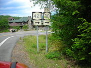 NY 421 begins at an intersection with NY 30
near the St. Lawrence
– Franklin
County line in the town of Piercefield
, located near the center of Adirondack Park. The highway heads northward as the two-lane Paradise Point Road, offering access to private residences as it crosses over the Bog River
and runs along the western edge of Tupper Lake
. After 1.6 miles (2.6 km), NY 421 comes to the Veterans' Mountain Camp at Paradise Point. Here, Paradise Point Road continues east to the camp while NY 421 heads north to a cluster of buildings at a junction with Warren Point Road. Here, NY 421 turns to head westward into the wilderness of the park.
It proceeds west for roughly 2 miles (3.2 km) before curving to the southwest as it approaches Horseshoe Lake
. It runs along the southern edge of the lake to its western extent, where it turns northward to follow the lake's western shore to the isolated hamlet of Horseshoe. The route proceeds northward through Horseshoe to what was once a railroad crossing, where NY 421 comes to an end. The roadway also ends here, as only dirt trails exist beyond this point.
that is now part of NY 30
) to the new Veterans' Mountain Camp, an American Legion
camp on Tupper Lake
. The work was funded through appropriations defined in the law. The highway was completed by 1929 and extended from modern NY 30 north to a dead end at Warren Point. In the 1930 renumbering of state highways in New York, hundreds of state-maintained highways that did not yet have a designation were assigned one. The Veterans' Mountain Camp highway was designated as NY 421 by the following year.
A highway leading westward from NY 421 southwest of Warren Point to Horseshoe Lake
was completed ca. 1962. It became part of an extended NY 421 by 1968. The former routing of NY 421 north to Warren Point, legislatively designated as State Highway 9106B, was initially considered a spur of NY 421; it was later redesignated as NY 971D, an unsigned reference route. After the Veterans' Mountain Camp was closed in the 1960s, the property was sold off to private owners, turning NY 971D into little more than a private drive. Thus, the road saw little use, handling less than 10 vehicles per day on average. As a result, the New York State Department of Transportation
(NYSDOT) no longer considered the highway worthy of inclusion in the state highway system and began to take steps to remove the highway from the system.
On February 22, 1999, NYSDOT sent a memorandum to the New York State Senate
that laid out the groundwork for a bill which, if passed, would allow NYSDOT to remove NY 971D from the state highway system once it was able to transfer ownership and maintenance of the highway to another entity. The memo was officially made into a bill on March 29 when State Senator Raymond Meier
introduced bill S4159 in the New York State Senate
. An identical bill (A8056) was introduced in the New York State Assembly
on April 26 by the Assembly Rules Committee at the request of Assemblyman David Gantt
. S4159 passed the Senate on April 28 and replaced A8056 in the Assembly on June 17, on which day it also passed the Assembly. The bill was signed into law by Governor George Pataki
on July 27, 1999. The former routing of NY 971D is now officially a private drive.
State highway
State highway, state road or state route can refer to one of three related concepts, two of them related to a state or provincial government in a country that is divided into states or provinces :#A...
located within Adirondack Park in the southeastern corner of St. Lawrence County, New York
St. Lawrence County, New York
St. Lawrence County is a county located in the U.S. state of New York. As of the 2010 census, the population was 111,944. The county seat is Canton. The county is named for the Saint Lawrence River, which in turn was named for the Catholic saint on whose Feast day the river was discovered by...
, United States
United States
The United States of America is a federal constitutional republic comprising fifty states and a federal district...
. It is a narrow, two-lane spur route connecting NY 30
New York State Route 30
New York State Route 30 is a state highway in the central part of New York in the United States. It extends for from an interchange with NY 17 in the Southern Tier to the Canadian border in the state's North Country, where it continues into Quebec as Route 138. On a regional level,...
to Horseshoe Lake
Horseshoe Lake
-in Canada:*Horseshoe Lake, in Seguin Township, Ontario*Horseshoe Lake , on the Pipestone River in Kenora District, Ontario*Horseshoe Lake, in Jasper National Park-in the United States:*Horseshoe Lake, Arizona...
by way of Tupper Lake
Tupper Lake (New York)
Tupper Lake is a lake in New York in the USA. The lake is in the Adirondack Park and crosses the county lines of St. Lawrence County and Franklin County....
. A dead end
Cul-de-sac
A cul-de-sac is a word of French origin referring to a dead end, close, no through road or court meaning dead-end street with only one inlet/outlet...
sign is posted immediately off NY 30, the only route with which it intersects. The entire road is located in the town of Piercefield
Piercefield, New York
Piercefield is a town in St. Lawrence County, New York, United States. The population was 305 at the 2000 census.The Town of Piercefield is in the southeast corner of the county and is southeast of Canton.- History :...
, although that name is not posted on NY 421. The route offers access to several picnic and snowmobile areas.
The eastern portion of NY 421 was built in the 1920s under the terms of a 1923 law authorizing the construction of a highway leading from modern NY 30 north to Warren Point. NY 421 was assigned to the entirety of the north–south highway ca. 1931. The roadway connecting Horseshoe Lake to Tupper Lake was built ca. 1962 and became part of NY 421 by 1968. NY 421's former routing to Warren Point remained a state highway up through 1999, when a law was passed allowing the New York State Department of Transportation
New York State Department of Transportation
The New York State Department of Transportation is responsible for the development and operation of highways, railroads, mass transit systems, ports, waterways and aviation facilities in the U.S...
(NYSDOT) to remove it from the state highway system once NYSDOT was able to transfer ownership and maintenance of the highway to another entity.
Route description
New York State Route 30
New York State Route 30 is a state highway in the central part of New York in the United States. It extends for from an interchange with NY 17 in the Southern Tier to the Canadian border in the state's North Country, where it continues into Quebec as Route 138. On a regional level,...
near the St. Lawrence
St. Lawrence County, New York
St. Lawrence County is a county located in the U.S. state of New York. As of the 2010 census, the population was 111,944. The county seat is Canton. The county is named for the Saint Lawrence River, which in turn was named for the Catholic saint on whose Feast day the river was discovered by...
– Franklin
Franklin County, New York
Franklin County is a county located in the U.S. state of New York. As of the 2010 census, the population was 51,599. It is named in honor of American Founding Father Benjamin Franklin...
County line in the town of Piercefield
Piercefield, New York
Piercefield is a town in St. Lawrence County, New York, United States. The population was 305 at the 2000 census.The Town of Piercefield is in the southeast corner of the county and is southeast of Canton.- History :...
, located near the center of Adirondack Park. The highway heads northward as the two-lane Paradise Point Road, offering access to private residences as it crosses over the Bog River
Bog River
The Bog River, also called the Bog River Flow is a river that originates near the sources of the Oswegatchie River, in Hamilton County, New York in the Adirondacks, and flows through Lows Lake and Hitchens Pond, ending at the Bog River Falls at the entrance to Tupper Lake. For much of its...
and runs along the western edge of Tupper Lake
Tupper Lake (New York)
Tupper Lake is a lake in New York in the USA. The lake is in the Adirondack Park and crosses the county lines of St. Lawrence County and Franklin County....
. After 1.6 miles (2.6 km), NY 421 comes to the Veterans' Mountain Camp at Paradise Point. Here, Paradise Point Road continues east to the camp while NY 421 heads north to a cluster of buildings at a junction with Warren Point Road. Here, NY 421 turns to head westward into the wilderness of the park.
It proceeds west for roughly 2 miles (3.2 km) before curving to the southwest as it approaches Horseshoe Lake
Horseshoe Lake
-in Canada:*Horseshoe Lake, in Seguin Township, Ontario*Horseshoe Lake , on the Pipestone River in Kenora District, Ontario*Horseshoe Lake, in Jasper National Park-in the United States:*Horseshoe Lake, Arizona...
. It runs along the southern edge of the lake to its western extent, where it turns northward to follow the lake's western shore to the isolated hamlet of Horseshoe. The route proceeds northward through Horseshoe to what was once a railroad crossing, where NY 421 comes to an end. The roadway also ends here, as only dirt trails exist beyond this point.
History
In 1923, the New York State Legislature passed a law authorizing the construction of a highway connecting Route 24 (an unsigned legislative routeLegislative route
In United States, a legislative route or legislative highway is a highway defined by laws passed in a state legislature. The numbering of such highways may or may not correspond to the numbers familiar to the public as part of the state, U.S. highway, and Interstate highway systems...
that is now part of NY 30
New York State Route 30
New York State Route 30 is a state highway in the central part of New York in the United States. It extends for from an interchange with NY 17 in the Southern Tier to the Canadian border in the state's North Country, where it continues into Quebec as Route 138. On a regional level,...
) to the new Veterans' Mountain Camp, an American Legion
American Legion
The American Legion is a mutual-aid organization of veterans of the United States armed forces chartered by the United States Congress. It was founded to benefit those veterans who served during a wartime period as defined by Congress...
camp on Tupper Lake
Tupper Lake (New York)
Tupper Lake is a lake in New York in the USA. The lake is in the Adirondack Park and crosses the county lines of St. Lawrence County and Franklin County....
. The work was funded through appropriations defined in the law. The highway was completed by 1929 and extended from modern NY 30 north to a dead end at Warren Point. In the 1930 renumbering of state highways in New York, hundreds of state-maintained highways that did not yet have a designation were assigned one. The Veterans' Mountain Camp highway was designated as NY 421 by the following year.
A highway leading westward from NY 421 southwest of Warren Point to Horseshoe Lake
Horseshoe Lake
-in Canada:*Horseshoe Lake, in Seguin Township, Ontario*Horseshoe Lake , on the Pipestone River in Kenora District, Ontario*Horseshoe Lake, in Jasper National Park-in the United States:*Horseshoe Lake, Arizona...
was completed ca. 1962. It became part of an extended NY 421 by 1968. The former routing of NY 421 north to Warren Point, legislatively designated as State Highway 9106B, was initially considered a spur of NY 421; it was later redesignated as NY 971D, an unsigned reference route. After the Veterans' Mountain Camp was closed in the 1960s, the property was sold off to private owners, turning NY 971D into little more than a private drive. Thus, the road saw little use, handling less than 10 vehicles per day on average. As a result, the New York State Department of Transportation
New York State Department of Transportation
The New York State Department of Transportation is responsible for the development and operation of highways, railroads, mass transit systems, ports, waterways and aviation facilities in the U.S...
(NYSDOT) no longer considered the highway worthy of inclusion in the state highway system and began to take steps to remove the highway from the system.
On February 22, 1999, NYSDOT sent a memorandum to the New York State Senate
New York State Senate
The New York State Senate is one of two houses in the New York State Legislature and has members each elected to two-year terms. There are no limits on the number of terms one may serve...
that laid out the groundwork for a bill which, if passed, would allow NYSDOT to remove NY 971D from the state highway system once it was able to transfer ownership and maintenance of the highway to another entity. The memo was officially made into a bill on March 29 when State Senator Raymond Meier
Raymond Meier
Raymond A. "Ray" Meier was born on October 23, 1952, in Rome, New York to Alfred and Irene Meier. Mr. Meier served as a Republican in the New York State Senate representing New York's 47th district for five terms. The 47th Senate district comprises Lewis County as well as portions of St...
introduced bill S4159 in the New York State Senate
New York State Senate
The New York State Senate is one of two houses in the New York State Legislature and has members each elected to two-year terms. There are no limits on the number of terms one may serve...
. An identical bill (A8056) was introduced in the New York State Assembly
New York State Assembly
The New York State Assembly is the lower house of the New York State Legislature. The Assembly is composed of 150 members representing an equal number of districts, with each district having an average population of 128,652...
on April 26 by the Assembly Rules Committee at the request of Assemblyman David Gantt
David Gantt
David F. Gantt is a Democrat member of the New York State Assembly representing the 133rd Assembly District, which includes the northeast and southwest sections of the city of Rochester and the suburban town of Gates....
. S4159 passed the Senate on April 28 and replaced A8056 in the Assembly on June 17, on which day it also passed the Assembly. The bill was signed into law by Governor George Pataki
George Pataki
George Elmer Pataki is an American politician who was the 53rd Governor of New York. A member of the Republican Party, Pataki served three consecutive four-year terms from January 1, 1995 until December 31, 2006.- Early life :...
on July 27, 1999. The former routing of NY 971D is now officially a private drive.