
New York State Route 348
Encyclopedia
New York State Route 348 (NY 348) was a state highway
located within the town of Chazy
in Clinton County, New York
, United States
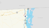
. It stretched for 6.2 miles (10 kilometers) from NY 22
in the hamlet of West Chazy to U.S. Route 9 (US 9) in the hamlet of Chazy and passed under the Adirondack Northway (Interstate 87 or I-87). NY 348 did not intersect any state routes or pass through any communities other than those at each of its termini.
When NY 348 was originally assigned as part of the 1930 renumbering of state highways in New York, it began in West Chazy and ended in the village of Champlain
. The route was extended northeastward to Rouses Point
by 1931, then truncated to the hamlet of Chazy in the early 1960s. NY 348 ceased to exist entirely in 1980, at which time its former routing became County Route 24 (CR 24).
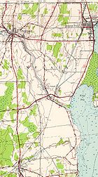 Further northeast, Route 348 passed Kinsey Road. The highway then paralleled Route 22 as it continued to the northeast. Route 348 then intersected Slosson Road just after 2 miles (3 km). It then intersected with Clark Street and Ridge Road before turning to the east. A little time later, Route 348 crossed over the Adirondack Northway (I-87
) with no access to the expressway. Route 348 ended shortly afterward at US 9 in Chazy
just north of the Little Chazy River.
in the hamlet of West Chazy and ended at US 11
in the village of Champlain
. NY 348 had an overlap with US 9 from Chazy
to what is now NY 9B
in the town of Champlain
. Here, US 9 forked to the east and followed the length of modern NY 9B to Rouses Point
. NY 348 was extended east to Rouses Point along US 11 and what is now NY 276
by the following year.
In the mid-1940s, US 9 was rerouted to follow its modern alignment through Champlain, creating a lengthy overlap between NY 348 and US 9 from Chazy hamlet to Champlain village. The overlaps with both US 9 and US 11 were eliminated in the early 1960s after NY 348 was truncated on its northern end to its junction with US 9 in Chazy.
NY 348 was removed from the state highway system in 1980. The designation officially ceased to exist on January 7, 1980, and ownership and maintenance of the route was transferred from the state of New York
to Clinton County
on April 1, 1980, as part of a highway maintenance swap between the two levels of government. The former routing of NY 348 was redesignated as CR 24.
The bridge that carried NY 348 over the Little Chazy River just south of its junction with US 9 in Chazy was rehabilitated in 1995, 80 years after its initial construction in 1915.
State highway
State highway, state road or state route can refer to one of three related concepts, two of them related to a state or provincial government in a country that is divided into states or provinces :#A...
located within the town of Chazy
Chazy, New York
Chazy is a town in northeastern Clinton County, New York, in the United States. The population was 4,284 at the 2010 census. The closest city is Plattsburgh, to the south. Chazy is from Canada. The zip code is 12921 and it is in area code 518.- History:...
in Clinton County, New York
Clinton County, New York
Clinton County is a county located in the U.S. state of New York. As of the 2010 census, the population was 82,128. Its name is in honor of the first Governor of New York as a state, George Clinton. Its county seat is Plattsburgh.-History:...
, United States
United States
The United States of America is a federal constitutional republic comprising fifty states and a federal district...
. It stretched for 6.2 miles (10 kilometers) from NY 22
New York State Route 22
New York State Route 22 is a north–south state highway in eastern New York in the United States. It runs parallel to the state's eastern edge from the outskirts of New York City to a short distance south of the Canadian border. At , it is the state's longest north–south route and...
in the hamlet of West Chazy to U.S. Route 9 (US 9) in the hamlet of Chazy and passed under the Adirondack Northway (Interstate 87 or I-87). NY 348 did not intersect any state routes or pass through any communities other than those at each of its termini.
When NY 348 was originally assigned as part of the 1930 renumbering of state highways in New York, it began in West Chazy and ended in the village of Champlain
Champlain (village), New York
Champlain is a village in Clinton County, New York, USA. The population was 1,101 at the 2010 census. The village is named after nearby Lake Champlain.The Village of Champlain in located in the Town of Champlain and is north of Plattsburgh.-History:...
. The route was extended northeastward to Rouses Point
Rouses Point, New York
Rouses Point is a village in Clinton County, New York, United States, along the 45th parallel. The population was 2,209 at the 2010 census. The village is named after Jacques Rouse, an early settler....
by 1931, then truncated to the hamlet of Chazy in the early 1960s. NY 348 ceased to exist entirely in 1980, at which time its former routing became County Route 24 (CR 24).
Route description
NY 348 began at an intersection with Route 22 and West Church Street in the hamlet of West Chazy, located 2 miles (3.2 km) east of Flat Rock State Forest. The route headed eastward, intersecting with local roads. After crossing a pair railroad tracks, Route 348 turned to the northeast towards Chazy at an intersection with Ketchum Bridge Road and Stratton Hill Road. As the highway headed to the northeast, it passed through rural sections of Clinton County, full of farms and forests.Interstate 87
Interstate 87 is a Interstate Highway located entirely within New York State in the United States of America. I-87 is the longest intrastate Interstate highway in the Interstate Highway System. Its southern end is at the Bronx approaches of the Robert F. Kennedy Bridge in New York City...
) with no access to the expressway. Route 348 ended shortly afterward at US 9 in Chazy
Chazy, New York
Chazy is a town in northeastern Clinton County, New York, in the United States. The population was 4,284 at the 2010 census. The closest city is Plattsburgh, to the south. Chazy is from Canada. The zip code is 12921 and it is in area code 518.- History:...
just north of the Little Chazy River.
History
NY 348 was assigned as part of the 1930 renumbering of state highways in New York. At the time, it began at NY 22New York State Route 22
New York State Route 22 is a north–south state highway in eastern New York in the United States. It runs parallel to the state's eastern edge from the outskirts of New York City to a short distance south of the Canadian border. At , it is the state's longest north–south route and...
in the hamlet of West Chazy and ended at US 11
U.S. Route 11 in New York
U.S. Route 11 is a part of the U.S. Highway System that runs from New Orleans, Louisiana, to the Canadian border at Rouses Point, New York...
in the village of Champlain
Champlain (village), New York
Champlain is a village in Clinton County, New York, USA. The population was 1,101 at the 2010 census. The village is named after nearby Lake Champlain.The Village of Champlain in located in the Town of Champlain and is north of Plattsburgh.-History:...
. NY 348 had an overlap with US 9 from Chazy
Chazy, New York
Chazy is a town in northeastern Clinton County, New York, in the United States. The population was 4,284 at the 2010 census. The closest city is Plattsburgh, to the south. Chazy is from Canada. The zip code is 12921 and it is in area code 518.- History:...
to what is now NY 9B
New York State Route 9B
New York State Route 9B is a state highway located within Clinton County, New York, in the United States. The route serves as a connector between its parent route, U.S. Route 9 , in the town of Champlain and US 11 in the village of Rouses Point...
in the town of Champlain
Champlain (town), New York
Champlain is a town in Clinton County, New York, United States. The population was 5,754 at the 2010 census. The town is named after Lake Champlain....
. Here, US 9 forked to the east and followed the length of modern NY 9B to Rouses Point
Rouses Point, New York
Rouses Point is a village in Clinton County, New York, United States, along the 45th parallel. The population was 2,209 at the 2010 census. The village is named after Jacques Rouse, an early settler....
. NY 348 was extended east to Rouses Point along US 11 and what is now NY 276
New York State Route 276
New York State Route 276 is a state highway located entirely within Clinton County, New York, in the United States. It connects the town of Champlain to the village of Rouses Point, with both termini situated at intersections with U.S. Route 11 about apart...
by the following year.
In the mid-1940s, US 9 was rerouted to follow its modern alignment through Champlain, creating a lengthy overlap between NY 348 and US 9 from Chazy hamlet to Champlain village. The overlaps with both US 9 and US 11 were eliminated in the early 1960s after NY 348 was truncated on its northern end to its junction with US 9 in Chazy.
NY 348 was removed from the state highway system in 1980. The designation officially ceased to exist on January 7, 1980, and ownership and maintenance of the route was transferred from the state of New York
New York
New York is a state in the Northeastern region of the United States. It is the nation's third most populous state. New York is bordered by New Jersey and Pennsylvania to the south, and by Connecticut, Massachusetts and Vermont to the east...
to Clinton County
Clinton County, New York
Clinton County is a county located in the U.S. state of New York. As of the 2010 census, the population was 82,128. Its name is in honor of the first Governor of New York as a state, George Clinton. Its county seat is Plattsburgh.-History:...
on April 1, 1980, as part of a highway maintenance swap between the two levels of government. The former routing of NY 348 was redesignated as CR 24.
The bridge that carried NY 348 over the Little Chazy River just south of its junction with US 9 in Chazy was rehabilitated in 1995, 80 years after its initial construction in 1915.