
New York State Route 333
Encyclopedia
New York State Route 333 (NY 333) was an east–west state highway
located in southeastern Steuben County, New York
, United States
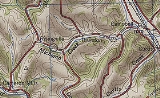
. The western terminus of the route was at an intersection with County Route 11 (CR 11) and CR 24 in Risingville, a hamlet within the town of Thurston
. Its eastern terminus was at a junction with NY 415
in the town of Campbell
. In between, NY 333 passed through the hamlet of Thurston. The route was assigned as part of the 1930 renumbering of state highways in New York and remained unchanged until April 1, 1997, when ownership and maintenance of the route was transferred from the state of New York
to Steuben County as part of a highway maintenance swap between the two levels of government. NY 333 was subsequently redesignated as County Route 333.
town of Thurston
. It headed eastward, following Michigan Creek along the base of a valley surrounding the waterway. Due to the terrain of the area, NY 333 intersected only a handful of roads, one of which was Cranberry Lake Road (CR 2), a north–south highway that met NY 333 midway between the hamlets of Risingville and Thurston. The route continued onward, turning northeastward toward Thurston Pond and the small hamlet of Thurston at the eastern edge of the small lake. Here, NY 333 curved back to the east as it met Savona–Thurston Road (CR 12) in the western half of the community.
East of Thurston hamlet, NY 333 continued to run along the base of the Michigan Creek valley into the town of Campbell
, where the valley met a larger valley surrounding the Cohocton River
. The route proceeded eastward across the width of the latter valley, crossing over the river on its way into the riverside hamlet of Campbell, the largest community along NY 333. It proceeded eastward through the hamlet along Main Street to an interchange with the Southern Tier Expressway (then-NY 15
and NY 17
) just east of the community. NY 333 ended about 0.5 mile (0.80467 km) later at a junction with NY 415
.
) in Campbell
to the hamlet of Risingville in the town of Thurston
. It remained unchanged until April 1, 1997, when ownership and maintenance of the route was transferred from the state of New York
to Steuben County
as part of a highway maintenance swap between the two levels of government. In the switch, NY 333 and nearby NY 432, both maintained by the state, were given to Steuben County in exchange for maintenance of NY 415
from Meads Creek Road in Coopers Plains (northwest of Painted Post
) to Babcock Hollow Road in Bath
as well as for maintenance of Hamilton Street (the original routing of NY 17
) between US 15 and Gang Mills
. NY 333 was redesignated as CR 333 as a result.
State highway
State highway, state road or state route can refer to one of three related concepts, two of them related to a state or provincial government in a country that is divided into states or provinces :#A...
located in southeastern Steuben County, New York
Steuben County, New York
Steuben County is a county located in the U.S. state of New York. As of the 2010 census, the population was 98,990. Its name is in honor of Baron von Steuben, a German general who fought on the American side in the American Revolutionary War, though it is not pronounced the same...
, United States
United States
The United States of America is a federal constitutional republic comprising fifty states and a federal district...
. The western terminus of the route was at an intersection with County Route 11 (CR 11) and CR 24 in Risingville, a hamlet within the town of Thurston
Thurston, New York
Thurston is a town in Steuben County, New York, United States. The population was 1,309 at the 2000 census. The town is named after early landowner William Thurston.The Town of Thurston is the east-central part of the county, northwest of Corning, NY....
. Its eastern terminus was at a junction with NY 415
New York State Route 415
New York State Route 415 is a state highway located in Steuben County, New York, United States. It is a north–south trunk road that parallels in part, the Cohocton River, Interstate 86 and Interstate 390. The southern terminus of the route is at an intersection with NY 414 in...
in the town of Campbell
Campbell, New York
Campbell is a town in Steuben County, New York, United States. The population was 3,691 at the 2000 census. The name is from Robert Campbell, an early landowner.The Town of Campbell is centrally located in the county and is northwest of Corning....
. In between, NY 333 passed through the hamlet of Thurston. The route was assigned as part of the 1930 renumbering of state highways in New York and remained unchanged until April 1, 1997, when ownership and maintenance of the route was transferred from the state of New York
New York
New York is a state in the Northeastern region of the United States. It is the nation's third most populous state. New York is bordered by New Jersey and Pennsylvania to the south, and by Connecticut, Massachusetts and Vermont to the east...
to Steuben County as part of a highway maintenance swap between the two levels of government. NY 333 was subsequently redesignated as County Route 333.
Route description
NY 333 began at an intersection with CR 11 and CR 24 in Risingville, an isolated hamlet within the Steuben CountySteuben County, New York
Steuben County is a county located in the U.S. state of New York. As of the 2010 census, the population was 98,990. Its name is in honor of Baron von Steuben, a German general who fought on the American side in the American Revolutionary War, though it is not pronounced the same...
town of Thurston
Thurston, New York
Thurston is a town in Steuben County, New York, United States. The population was 1,309 at the 2000 census. The town is named after early landowner William Thurston.The Town of Thurston is the east-central part of the county, northwest of Corning, NY....
. It headed eastward, following Michigan Creek along the base of a valley surrounding the waterway. Due to the terrain of the area, NY 333 intersected only a handful of roads, one of which was Cranberry Lake Road (CR 2), a north–south highway that met NY 333 midway between the hamlets of Risingville and Thurston. The route continued onward, turning northeastward toward Thurston Pond and the small hamlet of Thurston at the eastern edge of the small lake. Here, NY 333 curved back to the east as it met Savona–Thurston Road (CR 12) in the western half of the community.
East of Thurston hamlet, NY 333 continued to run along the base of the Michigan Creek valley into the town of Campbell
Campbell, New York
Campbell is a town in Steuben County, New York, United States. The population was 3,691 at the 2000 census. The name is from Robert Campbell, an early landowner.The Town of Campbell is centrally located in the county and is northwest of Corning....
, where the valley met a larger valley surrounding the Cohocton River
Cohocton River
The Cohocton River is a tributary of the Chemung River in western New York in the United States. Via the Chemung River, it is part of the Susquehanna River watershed, flowing to Chesapeake Bay...
. The route proceeded eastward across the width of the latter valley, crossing over the river on its way into the riverside hamlet of Campbell, the largest community along NY 333. It proceeded eastward through the hamlet along Main Street to an interchange with the Southern Tier Expressway (then-NY 15
New York State Route 15
New York State Route 15 is a north–south state highway located in western New York in the United States. The southern terminus of the route is officially at Interstate 390 exit 3 south of the village of Wayland, although some signage indicating that NY 15 continues south to...
and NY 17
New York State Route 17
New York State Route 17 is a state highway that extends for through the Southern Tier and Downstate regions of New York in the United States...
) just east of the community. NY 333 ended about 0.5 mile (0.80467 km) later at a junction with NY 415
New York State Route 415
New York State Route 415 is a state highway located in Steuben County, New York, United States. It is a north–south trunk road that parallels in part, the Cohocton River, Interstate 86 and Interstate 390. The southern terminus of the route is at an intersection with NY 414 in...
.
History
NY 333 was assigned as part of the 1930 renumbering of state highways in New York as a spur connecting U.S. Route 15 (US 15, now NY 415New York State Route 415
New York State Route 415 is a state highway located in Steuben County, New York, United States. It is a north–south trunk road that parallels in part, the Cohocton River, Interstate 86 and Interstate 390. The southern terminus of the route is at an intersection with NY 414 in...
) in Campbell
Campbell, New York
Campbell is a town in Steuben County, New York, United States. The population was 3,691 at the 2000 census. The name is from Robert Campbell, an early landowner.The Town of Campbell is centrally located in the county and is northwest of Corning....
to the hamlet of Risingville in the town of Thurston
Thurston, New York
Thurston is a town in Steuben County, New York, United States. The population was 1,309 at the 2000 census. The town is named after early landowner William Thurston.The Town of Thurston is the east-central part of the county, northwest of Corning, NY....
. It remained unchanged until April 1, 1997, when ownership and maintenance of the route was transferred from the state of New York
New York
New York is a state in the Northeastern region of the United States. It is the nation's third most populous state. New York is bordered by New Jersey and Pennsylvania to the south, and by Connecticut, Massachusetts and Vermont to the east...
to Steuben County
Steuben County, New York
Steuben County is a county located in the U.S. state of New York. As of the 2010 census, the population was 98,990. Its name is in honor of Baron von Steuben, a German general who fought on the American side in the American Revolutionary War, though it is not pronounced the same...
as part of a highway maintenance swap between the two levels of government. In the switch, NY 333 and nearby NY 432, both maintained by the state, were given to Steuben County in exchange for maintenance of NY 415
New York State Route 415
New York State Route 415 is a state highway located in Steuben County, New York, United States. It is a north–south trunk road that parallels in part, the Cohocton River, Interstate 86 and Interstate 390. The southern terminus of the route is at an intersection with NY 414 in...
from Meads Creek Road in Coopers Plains (northwest of Painted Post
Painted Post, New York
Painted Post is a village in Steuben County, New York, United States. The village is in the town of Erwin, west of the city of Corning. The population was 1,842 at the 2000 census. The name comes from a painted and carved post found by explorers at the junction of three local rivers...
) to Babcock Hollow Road in Bath
Bath (village), New York
Bath is a village in Steuben County, New York, United States. The population was 5,641 at the 2000 census. Bath is the county seat of Steuben County. The community was named either for the English city or for Lady Bath, daughter of William Pulteney, one of the original landowners.The Village of...
as well as for maintenance of Hamilton Street (the original routing of NY 17
New York State Route 17
New York State Route 17 is a state highway that extends for through the Southern Tier and Downstate regions of New York in the United States...
) between US 15 and Gang Mills
Gang Mills, New York
Gang Mills is a hamlet in Steuben County, New York, United States. The population was 3,304 at the 2000 census.Gang Mills is in located in the town of Erwin, southwest of Corning.-Geography:...
. NY 333 was redesignated as CR 333 as a result.